As Bernalwood has previously noted, there are some hidden dynamics at work in the North Bernal real estate market along the Cesar Chavez corridor, where home-price inflation has been fueled in part by the neighborhood’s proximity to the private shuttle-bus routes that carry tech workers from San Francisco to Silicon Valley:
[Bernalwood has] heard from realtor sources that this corridor is already attracting interest from [tech-employed] buyers, precisely because it offers convenient access to freeways, public transit, and the arterial routes for those Wi-Fi-equipped, private commuter busses operated by the likes of Apple, Google, Yahoo, etc.
Thanks to the data-visualization wizards at San Francisco’s Stamen Design, we now have a way to actually see this, by way of a fascinating subway-style map that indicates the location of common shuttle bus routes, the companies they represent, and the approximate volume of people they carry:
Several Stamen staff live on Google shuttle routes, so we see those shuttles every day. They’re ubiquitous in San Francisco, but the scale and shape of the network is invisible.
We decided to try some dedicated observation. We sat 18th & Dolores one morning, and counted shuttles. We counted a new shuttle every five minutes or so; several different companies, high frequency. We also researched online sources like Foursquare to look for shuttle movements, and a 2011 San Francisco city report helped fill in gaps and establish basic routes. […]
We enlisted people to go to stops, measure traffic and count people getting off and on and we hired bike messengers to see where the buses went. The cyclists used Field Papers to transcribe the various routes and what they found out, which we recompiled back into a database of trips, stops, companies and frequency. At a rough estimate, these shuttles transport about 35% of the amount of passengers Caltrain moves each day. Google alone runs about 150 trips daily, all over the city.
The result is the map you see above, which I annotated slightly to help the Citizens of Bernalwood orient the routes to our neighborhood. What the map reveals is that — no surprise — Cesar Chavez Blvd. is a major artery for tech shuttles carrying residents of San Francisco’s southern neighborhoods to and from Silicon Valley.
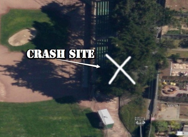
Another handy-dandy map (again, annotated by Bernalwood) reveals the actual location of the shuttle stops on the perimeters of Bernal Heights:

This is fascinating stuff, because while the shuttle buses themselves are highly conspicuous, their representation and scope has, until now, been largely hidden from view. Meanwhile, the impact of all this on Bernal Heights is also quite tangible.
IMAGES: Base maps from Stamen Design and Dotspotter