
Neighbor Isaac used an iPhone to capture this bucolic little scene atop Bernal Hill earlier this week. Loovley!
Neighbor Isaac used an iPhone to capture this bucolic little scene atop Bernal Hill earlier this week. Loovley!

Slides and notes have now been posted from last week’s meeting about the San Francisco Recreation and Park Department’s Bernal Trails Project.
I wrote up my own notes last week, but I was waiting for Rec and Park to release their map of the final trail proposal, which you can now see above. I made a Google Earth overlay of the previous version of the map, so… here’s an update! (KML, requires Google Earth.) As noted in the earlier post, Google Earth’s terrain model is somewhat lacking in detail, but it nevertheless illustrates the proposed changes with more dimensionality than a flat map.
I tried to match these screenshots to a couple of the gorgeous photos from the Bernalwood Air Force’s recent aerial reconnaissance mission. This pair shows the proposed new north-slope trail alignment:
NOW:

PROPOSED:

This view from the southwest shows a steep trail up to the top, above the Esmeralda stairs. The upper portion will likely be closed for erosion control. According to Rec & Park’s meeting notes, “existing trails denoted by dashed lines will either be decommissioned if they contribute to erosion or loss of habitat or be left in place but be unimproved.”
NOW:
PROPOSED:


This was probably inevitable.
It’s an established fact that Bernal’s own Sutrito Tower at the top of Bernal Hill is a bit of a Sutro Tower wannabe. Whatever the much bigger, much more famous Sutro does, Sutrito Tower wants to do too.
Well, along with the Bay Bridge, the TransAmerica Building, and One Rincon, Sutro Tower is also very active as an anthropomorphized presence on Twitter… so it was only a matter of time until the social-climbing Sutrito Tower decided to create an account as well:
Yes, if you follow @Sutrito, you no longer have to wonder what our iconic tower is pondering at any given time; instead, you can follow along in realtime to know *exactly* what he/she/it is thinking — or causing you to think via his/her/its diabolical mind-control powers. For example:
More importantly, as Bernalwood as always suspected, it seems that our Sutrito Tower leads an exciting double-life, functioning as a vital telecommunications relay tower by day, and an extraterrestrial beacon for earth-bound UFOs at night:
We urge you to follow @Sutrito on Twitter, to learn more about our tower’s revealing inner dialog, and to know in advance when you might wake up to find this happening in your own back yard:

PHOTOS: Telstar Logistics


Tis the season for wild California Poppies, and Julie captured several beautiful specimens during a walk on Bernal Hill last weekend:
The California State flower is the Eschscholzia californica. Known as the California Poppy or Golden Poppy, it is springing up everywhere. Here in San Francisco, it grows in the cracks of sidewalks and roads and can be found in all the parks. It varies in color from white to dark orange.
UPDATE: Ed Brownson added this gem to the Bernalwood Group on Flickr:

PHOTOS: Julie aka Rudha-an, Ed Brownson


Wednesday night I attended the last of three planned community meetings on the Bernal Trails Project, along with about twenty neighbors and several representatives from San Francisco’s Recreation and Parks department.
I’ve been to all of the meetings, and I’m impressed by the amount of consensus that’s been achieved, despite the wide range of opinions people brought.
The big news for me was the changes in the concept plan map from what was shown at the last meeting. The maps shown Wednesday night were conceptual, and detailed design development will take place over the summer, with involvement from a professional trail designer.
The new map and slides aren’t online yet, but here are some highlights:

Other questions were answered:
Sometime in May (TBD), the concept plan will be taken to a public meeting of Rec & Parks. Assuming it’s approved, detailed design development will be done between May and October. The bidding process for contractors will run from November through February 2013, so construction can be done next March through October.
Keep track of the project on Rec and Park’s Bernal Hill Urban Trails Project website.
PHOTOS: Aerial photos, Telstar Logistics. Graphics, SF Park and Rec

A tidy crowd assembled at Precita Park last weekend to take one of the newfangled electric bicycles from The New Wheel bike shop on a test drive up the fearsome Folsom Street hill.
Your Bernalwood reporter passed on Sunday’s opportunity, because I’d taken one of the bikes for a private ride the day before. My steed was a OHM Urban XU700 SE, which sells for $3699. It came with sporty amenities as leather grips, an air suspension, a rear rack and a 48V battery, in addition to a 0.5 horsepower electric motor tucked away in the rear hub. New Wheel owner Brett Thurber gave me a 30 second tutorial on how to adjust the bike’s motorized boost settings, and then I took off for adventure.

I started from The New Wheel shop on Cortland, but I immediately headed north, toward the top of Bernal Hill. The uniqueness of the electric bicycle became apparent from the moment when I began pedaling up Wool Street.
An electric bike is not like a scooter or a moped; the electric motor isn’t designed to work independently from the pedals. Instead, you pedal an electric bike just like a conventional bicycle, and when you do the electric motor provides a wonderful boost that makes each turn of the cranks carry you much, much farther than it would normally.
You can feel the assist from the electric motor as you pedal. It’s an odd sensation — kind of like having superhero strength or Six Million Dollar Man bionic implants. I was huffing and puffing when I reached the top of Wool, but I was huffing much less than I would have had I been on a regular bike, and the trip had taken about a third less time to complete.

I stopped to take a closer look at my machinery. There’s a little control panel on the right side of the handlebars that allows you to dial in how much electric-assist you want (as well as other bits of data such as power remaining, degree of battery-regenerating resistance, and so on). A thumb-activated “plus” switch lets you dial up the boost, and a “minus” reduces it. Below that, there’s a small red “cheat” button that activates the electric motor even when you’re not pedaling. (Brett Thurber hadn’t told me about that.)
From Wool I looped around Bernal Heights Boulevard and coasted down to Precita Park. Then I turned around to head up, up, up that fearsomely steep section of Folsom Street.
For your evidentiary satisfaction, this video captures the entire Folsom street climb, with musical accompaniment from the Bullitt soundtrack (which seemed appropriate).
As you can see, the electric bike made fast work of the hill, even though I was pedaling with one hand off the handlebars (to hold the video camera).
The electric bikes from The New Wheel are impressive machines. No, they’re not cheap; the least expensive one in the story goes for $2550. But then again, an electric bike is vastly cheaper than a Toyota Prius or a Chevy Volt, and much much much easier to park. For anyone looking for a practical way to get anywhere around town and get a little exercise at the same time, electric bikes may be an interesting option — even if your ride means a nightly trip home up that fearsome stretch of Folsom Street.
PHOTOS: Telstar Logistics

Reader Laurie has a question for the Bernalwood Intelligence Agency:
Do you think any of your readers would be able to ID this yellow flower, sketched on the west side of the hill yesterday?
The largest one was just over an inch in diameter.


Spring has sprung, Bernal Hill is alive with the sound of music, and in conjunction with the Bernal History Project, Neighbor Rachel is leading a wildflower walk tomorrow morning:
Wildflower Walk this Saturday, March 17th at 11:30 AM, Bernal Hill
Join us for a wildflower walk on the Hill. We’ll look at early wildflowers, including a locally rare population of star lilies (Zigadenus fremontii). Other current blooms include footsteps-of-spring, lomatium, shooting star, blue eyed grass, and checkerbloom.
Terry Milne will talk about some history on the hill and ways to conserve this grassland and the wildlife it supports.
We’ll meet at 11:30AM at the Ellsworth steps (intersection of Ellsworth and Bernal Heights Blvd).
This walk follows the monthly volunteer work party with Rec and Park, which begins at 10AM in the same location on the 3rd Saturday of every month.
Showers ok, steady rain cancels.
For more information you can email rachel.kesel [AT] sfgov [DOT] org or call 415-831-6332.
PHOTOS: Top, Telstar Logistics. Wildflowers, Rachel Kesel
Malki Means King recorded much of his new rap video atop Bernal Hill, and no wonder: He was looking for a location that embodies the grandeur of the Almighty:
Malki Means King raps about letting go and giving your faith to a higher power in this video. In order to achieve your goals and overcome any obstacle, I believe a faith in a higher power is needed. Nobody can do it by themselves, Let go and let God!


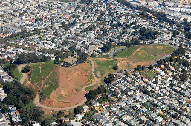
Last weekend the Cub Reporter and I had the opportunity to take to the skies with the Bernalwood Air Force for a routine observation and reconnaissance flight over the Bernal Heights motherland.
The skies were clear blue, Bernal Hill was verdant green, and because it was warm out, everyone was outside to enjoy the day. We cruised over Cortland, waving imperially at our neighbors below:

We saw people walking along the northwest corner of Bernal Heights Boulevard:
Nearby, our new neighbors from the Helipad House were enjoying some sunbathing on their glamorous roof deck:

Our technocrat friends at the City Rec and Park department will probably appreciate the documentation we collected about Bernal’s ad hoc trail network, and its myriad redundancies:
Look closely, and you can almost see the analysts working feverishly inside the secret Bernalwood Command Center, located 300 feet below Sutrito Tower:

While we were airborne, we received orders over the radio to undertake an urgent new mission: An aerial survey of the La Lengua Autonomous Zone!

Researchers from the Bernalwood Intelligence Agency had identified the likely location of the La Lengua Rebel Command Compound (LaLeRebCoCo), hidden deep in the heart of La Lenguan territory, between Mission and San Jose Streets. In 3 minutes we were over the target area. We circled to take a look, and captured the money shot. Behold:

Mission Accomplished! We loitered for a few final moments to take in some unusual perspectives on Bernal Hill:


And then, saturated with happy views and a lifetime of material for goofy Photoshop image-manipulation stunts, we returned to base.

UPDATE, 10:24 pm: In response to the Bernalwood Air Force overflight, the La Lengua rebels have put in place a high-tech burrito-based air defense system!
 PHOTOS: Telstar Logistics


Neighbor Joe Thomas has been attending the meetings hosted by the City Rec and Park Department on plans to renovate the trail network on Bernal Hill, and he’s been visualizing how the changes might look.
San Francisco Rec & Parks has posted notes from the last community meeting about trail restoration on Bernal Hill. Of particular interest is the presentation with a map (on page 41) of their “Concept Plan” for the trails. Several neighbors at the meeting remarked that it was difficult to visualize the lines on the map as actual trails, and one neighbor suggested that the proposed changes be marked in chalk on the hill so that folks could see them in context before the next (and last scheduled) community meeting on April 4.
I’d like to see and walk those chalked-in trails, myself. Until that happens, though, I thought I’d try to drape the flat trail maps onto Google Earth’s terrain model. (KML file, requires Google Earth.)
Fantastic work, Joe!
Rec and Park has also posted notes from their Q&A session (pdf) about the proposal, and they’re worth a look. Overall, the goal of the scheme is to minimize erosion and wear on the hill by consolidating the current network of paths into fewer, higher-density routes.
All that makes sense, though I wonder if we might also lose something along the way: That blessed sense of solitude that is now so easy to attain, even on days when Bernal Hill is teeming with visitors.
IMAGES: Joe Thomas

Actually, why bother restoring Bernal Hill’s trail network? And why bother fussing with all that pesky local flora. Why not just simplify things, with artificial grass? According to the billboard on Valencia at Cesar Chavez, Better Than Real Artificial Grass is actually BetterThanRealGrass.com.
Oh, and the website even says it’s “Eco-Friendly.”
Good to know!
UPDATE: Our hipster friends at Uptown Almanac noticed this juxtaposition too, and they have a different perspective:
Hey Bernal! Yeah you, I see you there. Look man, we gotta talk.
You’re cool and all, with those breathtaking views of San Francisco n’ shit. But you’ve been playing the same tune for thousands of years and people don’t wanna hear that no more. Yeah man, I’m talking about your grass situation. The pants stainer. The original weed. The green menace. Whatever you wanna call it, ‘shit’s played out–business as usual.
But, dude, check it: I got the fix for you. Art-a-ficial grah-ass. You heard of this stuff? No? Oh dude, it’s the fucking shit. We take your old, crabby-ass grass, dump it in some abandoned lot in Bayview, and then we cover your ass in plastic. Plastic! It’s modern, man–real cutting-edge shit. All the kids are playing soccer on it, it stays green year-round, and I heard it drains real well because, you know, sometimes rains in San Francisco.
PHOTO: Kelly Castro


Photographer Peter West Carey visited San Francisco from Seattle recently. He stayed with friends in Bernal Heights, and while he was here he took the opportunity to shoot an absolutely epic interactive panorama of the view from the north slope of Bernal Hill:
San Francisco Panorama Exploration
Location: Bernal Hill, San Francisco, California, USA, North AmericaDescription: Hidden behind the city form the popular skyline shot across the Golden Gate, Bernal Heights is not a place most tourists choose to visit. There are no sea lions, promenades or sightseeing boats found on the hill. Just a gorgeous view of the city and bay captured at sunset.
Shot with a Canon 7D and Canon 28-300mm L lens with settings of ISO 100, 100mm, f/9, 1/60th of a second. 132 images were shot in three rows in portrait oreintation and stitched with Kolor’s AutoPano Giga. Total size is approximately 488 megapixels, my largest to date.
We believe Peter actually meant to say “488 throbbing megapixels,” because his photo is so high-resolution that you can zoom in on far-away details of the San Francisco cityscape to view details that are impossible to see from Bernal Hill normally. Remember The Six Million Dollar Man and his bionic eyeball? It’s kind of like that.
Hello, Oakland!

Salutations, Golden Gate Bridge!

Buenos días, weird 1960s highrise US Bank building on Mission at 22nd!

It may take a little while to load — 488 megapixels, after all — and it probably won’t work at all if you’re on a mobile device. But Peter West Carey’s interactive panorama is worth every byte.
PHOTOS: Via Peter West Carey
