In Which We Explore an Aerial View of Bernal Hill, Circa 1924

BernalHillc1925jpg

Courtesy of our friends at the Bernal Heights History Project, we bring you this never-before seen aerial view of Bernal Hill. The photo comes via a private collection that was shared with BHHP, and it was likely taken sometime during the mid 1920s.

Why the mid-1920s? And when, exactly? There are a few clues that hint at the date, but first, let’s zoom and enhance to take a closer look:

BernalHillc1925.section1

Okay, so the most obvious indication of the date is the fact that the Sears Department Store has not yet been built on Mission Street near Army (Cesar Chavez). The Sears opened in 1929, yet in this photo the site is not yet under construction, so that likely means this photo was taken at least a few years before the grand opening.

The 1920s were a period of rapid transformation for this particular corner of Bernal. As La Legua rebel leader and archival history geek Burrito Justice has documented, suring the first two decades of the 1900s, Mission Street just south of Army had been home to a cluster of horse-related businesses — stables, harness manufacturers, and the like. Here’s what Mission Street at Precita looked like in May, 1923. Notice all the carriages in front of the McTigue Livery on the left:

missionprecita1923

Within a few years, the horse-related industry was quickly supplanted by car-related industry.  Here’s the same spot, in August, 1927. McTigue Livery has been replaced by Mission Chevrolet. There are also two new three-story apartment buildings next door, which today are the proud homes of El Rio and Virgil’s Sea Room (former Nap’s):

MissionPrecita1927

But returning to our new aerial photo, notice that none of this new development is present. The McTigue stable building from 1923 appears to have been torn down, but the the three-story El Rio/Virgil’s buildings have not yet been built:

BernalHillc1925x

All that tells us our photo is likely from sometime between 1923 and 1927.

Meanwhile, to the northeast…

BernalHillc1925.section2

South Van Ness (which was still called Howard Street at that point) still does not yet connect to Army — as had been the case back in 1888. The grand church of St. Anthony’s stands on Army near Folsom, right across the street from the campus of the Cogswell Polytechnical College. Streetcar tracks loop around Precita Park via Folsom, and those darn pedestrians have worn a path in the grass while taking shortcuts across the western end of the park.

That takes us to the summit of Bernal Hill, as seen from the southeast:

BernalHillc1925.section3

There’s no Bernal Heights Boulevard yet; that was a WPA project during the 1930s. Here, however, we can see a cluster of houses between Anderson and Ellsworth that was condemned and removed to make way for the road a decade later.

Two small quarries had been excavated from the south side of the hill, and as we all know, the scars from those operations remain quite vivid to this day.

Most surprising of all, however — at least to our precious contemporary sensibilities — is the giant advertising lettering at the top of this detail, on the northwest face of Bernal Hill, promoting  Maxwell automobiles. Apart from revealing a great deal about period attitudes toward landscape vista preservation, the Maxwell sign is also a useful chronology clue, since Maxwell was absorbed and discontinued by Chrysler in May, 1925. That suggests our photo likely predates the Maxwell shutdown.

Here’s a clearer shot of the Maxwell sign, as seen in the 1920s from around the intersection of Army and Valencia, again courtesy of the Bernal History Project. Notice those insane tilt-up automobile silhouettes at the summit of Bernal Hill!

BernalHill.1920s

Putting all the pieces together, we’re going to go out on a limb to say that this new photo likely dates from around 1924.

This is a photo-forensic field day for one and all, however, so if you see any other interesting details, or any other clues that might assist or conflict with our photo dating, please chime in via the comments.

Finally, hooray, Bernal Heights History Project!

Three Long-Lost Views of Army Street at Midcentury

Army:Mission.1949

Our friends at the Bernal Heights History Project recently pointed us toward a relatively obscure Facebook group dedicated to the history of the area around Precita Park.

That’s where we found the rather remarkable photo you see above, showing the intersection of Mission and Army (Cesar Chavez) looking east, shortly before the infamous “street-widening” project. The photo reveals that Army had already been widened to South Van Ness, and demolition is clearly underway on the north side of Army to extend the widening west to Mission Street. Look closely on the left side of the photo and you can also see the oddly-shaped, three-story apartment building that was later rotated 180-degrees and moved across the street when Army was finally widened.

There are also some terrific pictures of the original St. Anthony’s Church on Army near Folsom, which was destroyed in a suspicious June 1975 fire.

Here’s how St. Anthony’s looked from street level in 1965:

StAnthonys.1965

And here’s the real heartbreaker; check out this spectacular view of the church interior, as seen in 1958:

StAnthony'sChurch.1958

UPDATE: Let us not forget that rebel blogger and animated GIF historian Burrito Justice also created a spiffy overhead graphic that visualizes the transformation of Army at Mission that occurred as the street was widened. Click here to see it.

PHOTOS: via Precita Park in Bernal Heights on Facebook

Viva La Contra-Revolución! La Lengua Dissidents Dislike Funny Name, Seek to Rejoin Dominion of Bernalwood

Bernal1889.map3

Fellow Citizens of Bernalwood, this is a day we’ve long awaited.

We have endured years of rebellious bluster and seditious propaganda seeking to undermine the integrity of the Bernal Heights motherland. Yet we now have indications that the La Lengua separatist movement may be collapsing under the weight of its own geopolitical absurdity.

Last week, the Greater Bernalwood Signals Intelligence Unit received this encrypted communication from Neighbor Lisa, who resides deep within La Lenguan territory:

My neighbors and I have a problem. We have been saddled with an absolutely awful nickname for our little corner of San Francisco (La Lengua) and we don’t know how to get rid of it.

The blogosphere, including your esteemed and oft quoted blog, seems to think it is a great term, but the only person on our block who likes it is Burrito Justice himself. Every time someone shares a link to an article containing the hated term, our street mailing list fills up with emails suggesting alternatives. Even when the article is about a pot smoking bear, people get more excited about That Name.

We’d be happy to be referred to as Bernal Heights at this point.

So, how do we get people to use a different name for our microhood? I actually have some pretty strong feelings about what we should call my ‘hood, but unfortunately nobody likes my suggestion as much as I do. Anything but La Lengua.

And yes, every good revolution needs a splinter group.

Rest assured, Lisa, the Citizens of Bernalwood will be happy to welcome you back into our nurturing embrace!

IMAGE: Historic map from 1889 clearly includes the so-called La Lengua territories with the geographic boundaries of Bernal Heights. (On the other hand, this same map also includes six different streets named California Avenue, so draw your own conclusions.)

Bernal Heights Once Had Its Very Own Doggie Diner, and It Looked Fabulous

doggiedinerbernal1

Doggie Diner was a chain of fast food restaurants scattered around the Bay Area. The franchise enjoyed its heyday during a mid-1960s expansion, during which it installed rotating doggie-head mascots above each of its 30 or so restaurants. The doggie-heads became iconic in San Francisco, even after the Doggie Diner chain shut down for good in 1986.

The restaurants are gone, but a few of the giant fiberglass doggie mascots remain. There’s a lonely, restored one on a pole in the Sunset near the zoo, and there are three happy doggy diner heads mounted on a trailer that are often seen parked outside strange subculture spectacles around town:

trailerdoggies

But did you know that Bernal Heights once had its very own Doggie Diner? With its very own fiberglass doggie diner head? With its very own polkadot bow tie and chef’s hat?

We did. Our Doggie Diner stood at 3100 Mission, at the southwest corner of Army (Cesar Chavez). Here’s a zoom and enhance of the image from 1975 shown up above:

doggiedinerbernal.detail

Here’s a closeup of Bernal’s Doggie as it looked in 1981:

doggiediner.1981

Frankly, that just looks ridiculously awesome.

In fact, it’s so great that Bernal native and t-shirt design celebrity Amos Goldbaum gave the Bernal Doggie a cameo in his sexy new Bernal Hill shirt graphic:

bernalgoldbaumdog

Even better, Neighbor Amos also immortalized Bernal’s Lost Doggie Head in a special tribute illustration, which we are very pleased to debut for all Citizen of Bernalwood here:

amos.doggiehead

PHOTOS: Top, Doggie Diner 1975 via Amos Goldblum. Middle: Doggies on trailer by Tony Huerta. Doggie Diner 1981 via Jim Hair

Now Showing: The Lost History of the Former Cortland Theater

BERNAL1045 Cortland

Cortland-c-Dec-56-Bwood

BERNAL1047 Cortland as Capri

Capri-May-June-1958-header

Did you know there once was a movie theater on Cortland Avenue? The Cortland Theater (which became the Capri, after 1957) operated for more than 50 years (!!!) at 802 Cortland, in the building that’s now a church.

In this Bernalwood exclusive, the fabulous Vicky Walker from the Bernal History Project tells us the tale of this former Bernal landmark:

Before television, VCRs, DVDs, Four Star Video, TiVo, and Netflix streaming, residents of Bernal Heights went to the movies for entertainment. The Lyceum Theater on Mission Street was a short trip away, but if you didn’t want to walk down the hill, you could watch a movie at the Cortland Theatre at 802 Cortland.

The Cortland specialized in family-friendly double-features. Opened in 1915, it was revamped with a new facade in June 1957 and relaunched as the Capri Theatre. Despite the impact of television, the Cortland/Capri managed to survive until April 1969, and of course the building is now a church.

Jack Tillmany is a lifelong movie buff and the author of Theatres of San Francisco. In the 1950s, Jack signed up to receive The Cortland’s monthly calendar in the mail, so he often found himself at screenings in Bernal. Jack says:

“When I got my first car (in 1956), going to the movies in remote locations was an adventure. And since I lived in the Richmond District (near Geary Blvd. & 21st Avenue), Cortland Avenue definitely fell into that category.

“I was also concerned about seeing wide-screen movies in their proper ratio, and, I’m happy to report, The Cortland’s proscenium was wide enough to do just that. Alas, my own ‘local’ 4-Star’s did not, and so I never darkened their doors again after I saw how they squeezed and mutilated CinemaScope to fit their painfully too narrow screen in 1954!

“As a result I saw John Wayne in The High and the Mighty, Judy Garland in A Star Is Born, and, one of my personal favorites, Land of the Pharaohs, in their intended wide-screen grandeur at The Cortland.

Cortland-May-57-Bwood

“At least once a month, I would find some excuse to drive over to The Cortland even though the Alexandria, Coliseum, and Balboa were still in my geographical range.

“This all ended when I went into the Army in 1959; when I came back to the Bay Area two years later, I began managing theaters in the East Bay, and never had occasion to go back to The Cortland, which, by that time, had been renamed the Capri, with a new flat front. But I did return for one last hurrah, in 1966, when, on my night off from theatre management, I drove over from Oakland to see Peter Cushing in The Skull, which was just the sort of thing to see at the Capri!”

Along with all his other movie memorabilia. Jack kept the programs he got in the mail from The Cortland. A few years ago, he sold a few of them at his “Theaters of Mission Street” presentation for the Bernal History Project. Longtime Bernal resident and historian Jerry Schimmel purchased Jack’s last batch of Cortland and Capri programs, and he donated them to the Bernal Heights Branch Library. BHP scanned them as well.

Capri-June-July-1958-Bwood

The handwritten notes on some of the programs are quite charming. “SAVE CARFARE AND PARKING WORRIES,” one urges. “Patronize your neighborhood merchants. Movies are your best entertainment.”

Cortland 1955 Save-carfare-Bwood

Cortland-1955-nhood-merch-Bwood

Jack also provides proof that Bernal’s little movie house once competed with the likes of the Castro Theatre: In March 1958, the Cortland’s operator, Ward Stoopes (1926-1999), attempted to run silent films in the middle of the week, with portable organ accompaniment. Jack recalls:

“His first offering was A Tale of Two Worlds (1921), with Wallace Beery, filmed in San Francisco and shown via an original, tinted, 35MM print. I was among the very few in the audience, appreciative of the opportunity to see such a rarity, under such ideal circumstances. But, at the same time, future theatre manager that I was, I worried over the lack of attendance. Alas, the series failed, but, for me, at least it was a memorable moment.” 

Capri-May-June-1958-Bwood

Cortland-lion-Liberace-1956-Bwood

PHOTOS: Cortland Theater (year unknown) and Capri Theater facade (1965). All photos and programs courtesy of Jack Tillmany.

A Brief History of How Cesar Chavez/Army Street Became So Damn Awful in the First Place

chavez2008

The photo above (Thanks Mark!) shows a view of Cesar Chavez Boulevard looking west from Folsom in 2008, a few years before the current/ongoing sewer and streetscape improvement project got underway. As you can see, it is very unlovely.

In the comments to Monday’s item about the removal of the ugly-ass, freeway-style road sign across Cesar Chavez Boulevard, Neighbor Andy was prompted to wonder how Cesar Chavez Boulevard became so awful and so highway-like in the first place.

The short explanation is simple: Cesar Chavez — formerly Army Street — WAS designed to be a highway. Sort of. The wide thoroughfare as we now know it was carved out in the 1930s and 1940s, with the intention of using the road as a major east-west route to carry automobile traffic, first to the US101 Bayshore Freeway (which was built in the early 1950s), and eventually to the Southern Crossing, a second transbay bridge that was planned to terminate in the area around Army/Chavez and Third Street.

Wait. A second transbay bridge??? At the foot of Army/Chavez?? WHAT??!!

Follow along as we take a quick survey of Army Street history, give-or take a few years here and there:

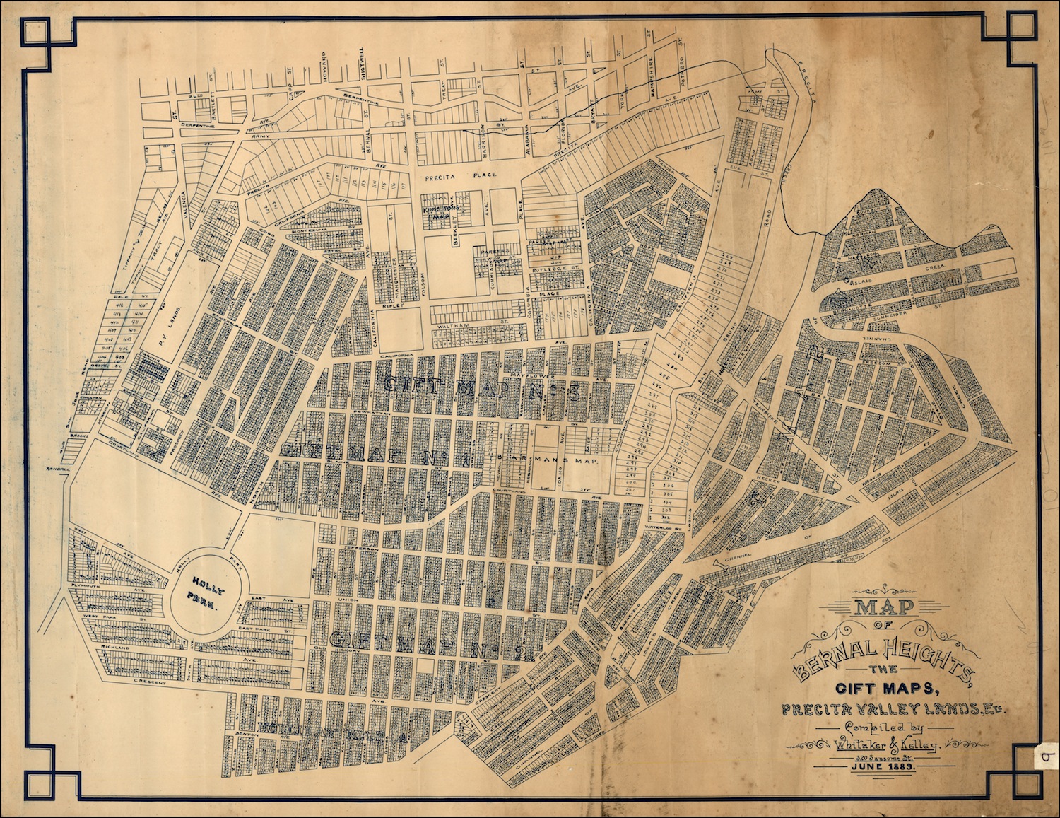
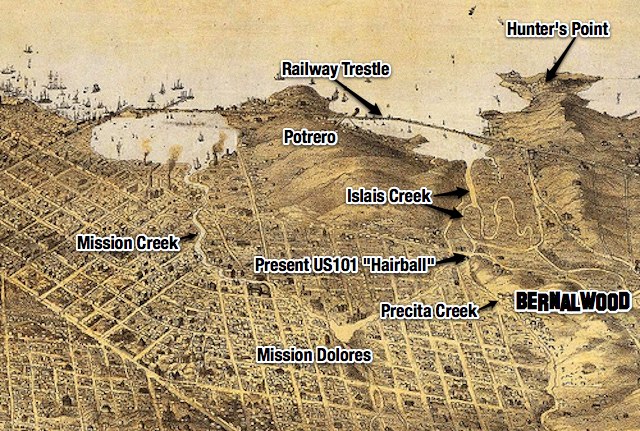
1859: Here, Precita Creek runs unfettered down the present-day Cesar Chavez Boulevard corridor, providing a primary route for water drainage for the eastern slopes of Twin Peaks. It also functions as a sewer. Present-day Precita Avenue shadows the route of the former Precita Creek. Army Street not created yet, but Navy Street ran parallel:

1888: Precita Creek still a creek. Army street is a jankey east-west road that runs alongside it:

mission-army-1888jpgx

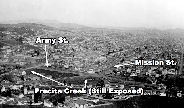
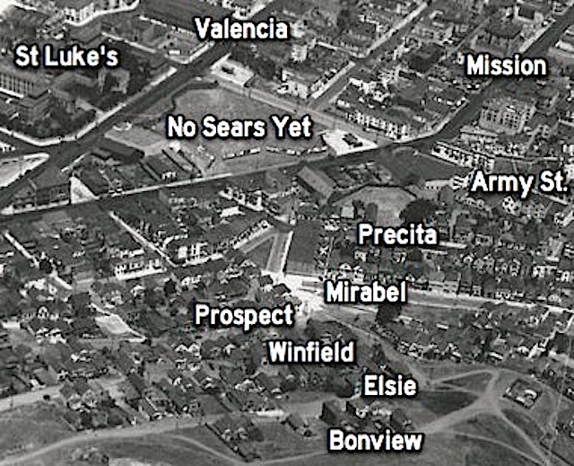
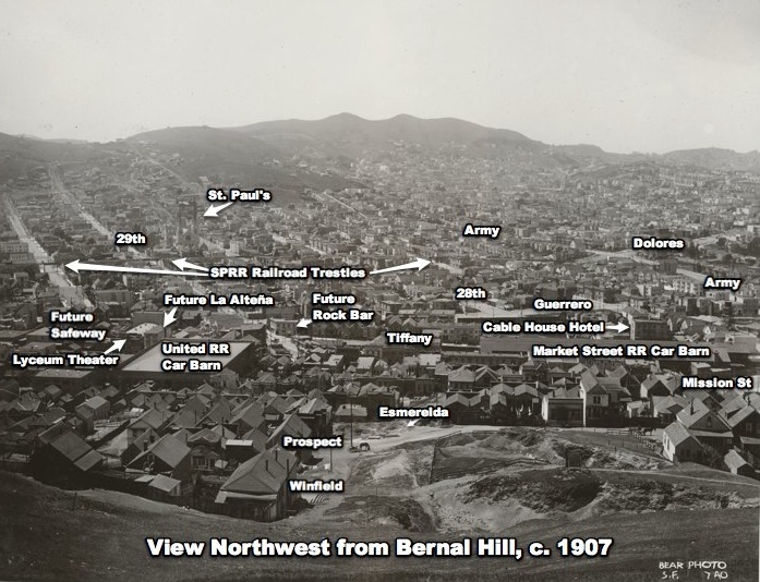
Circa 1900: Precita creek channeled underground, Army street built on top

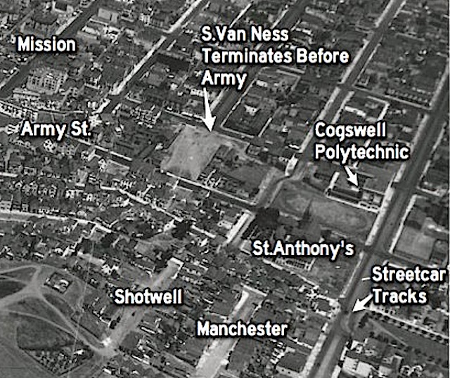
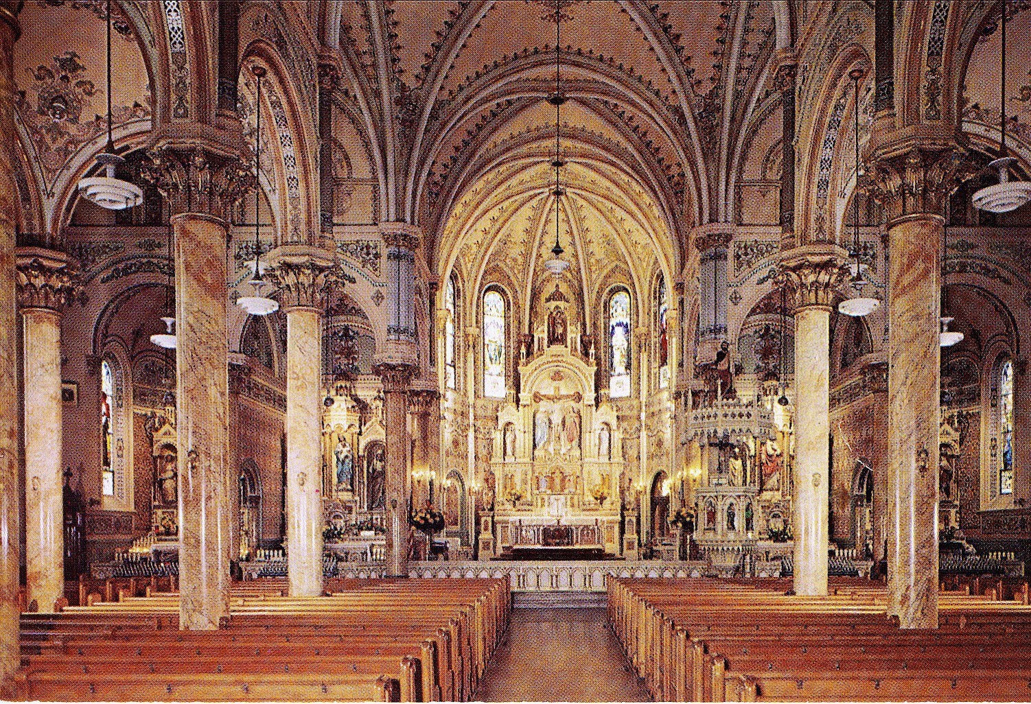
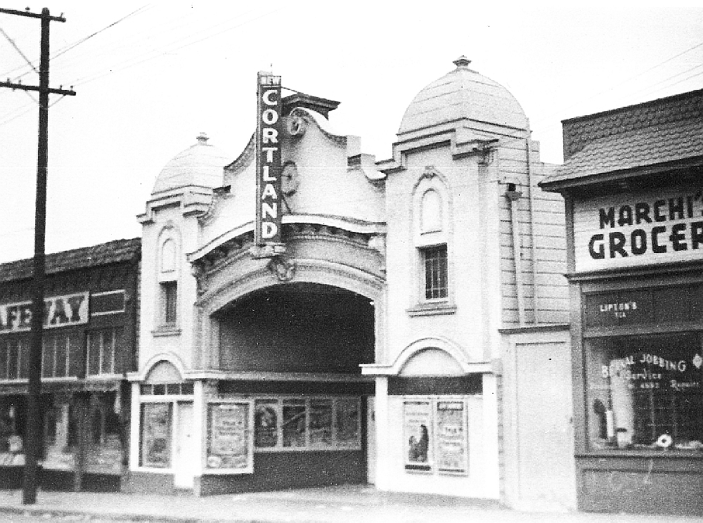
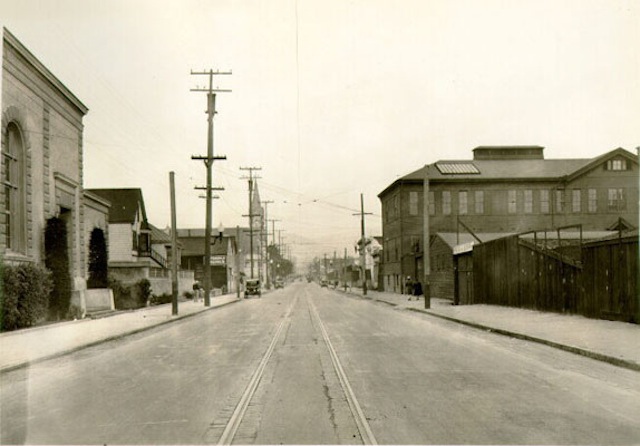
1931: Check out this amazing view of Army Street, looking west from Harrison, when it was a relatively normal San Francisco City Street (with a streetcar line!). That’s Le Conte Elementary School (now, Leonard Flynn) on the left, with the St. Anthony’s church steeple behind it. The church burned in the 1970s.

armyatharrison-1931

1936 and 1937: Bay Bridge and Golden Gate Bridge open to traffic.

Late 1930s: Army Street widened from a normal 4-lane city street to an 8-lane surface throroughfare. This is why many of the houses on the street are so close to the curb, with no front yards. Eminent domain is a bitch.

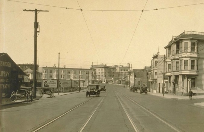
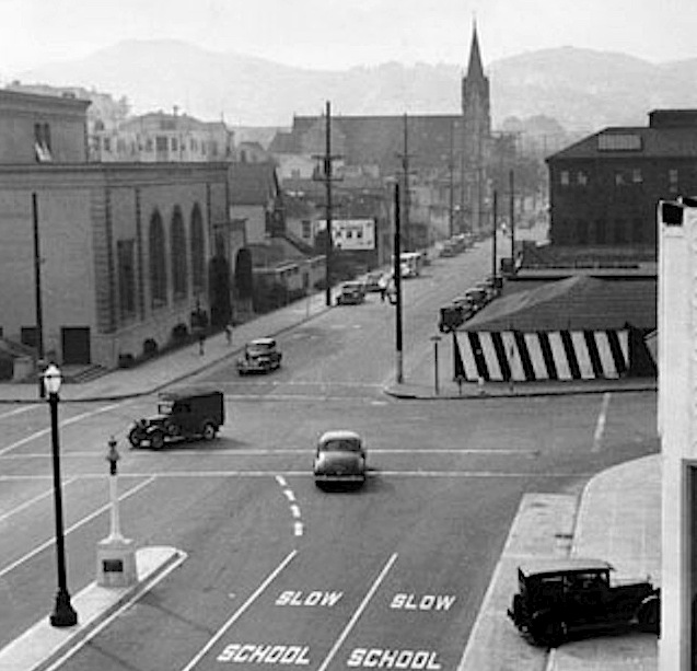
1940: View west on Army at Harrison again, showing both widened and unwidened portions. The caption on this photo hopes “the city soon may have the money to finish the widening.” Good times.

AAB-2898

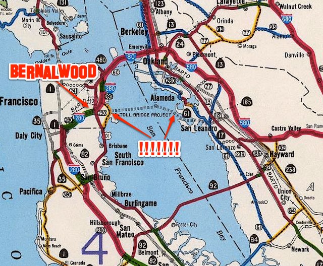
1940s: Flush with bridge-building ardor and postwar can-do, Southern Crossing bridge proposed.

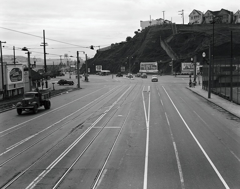
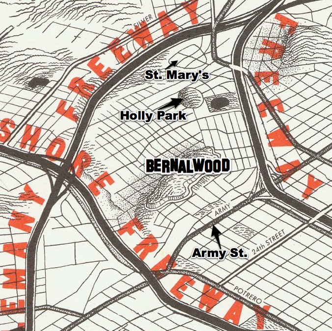
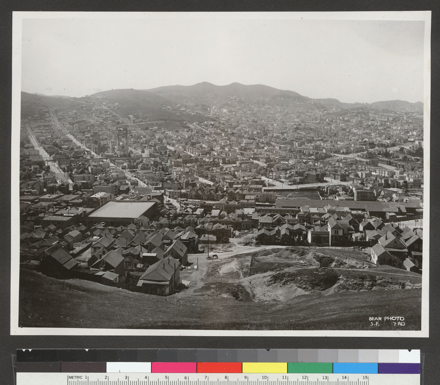
1947: Here’s a view looking south from Potrero Avenue at the Army Street intersection. That’s Bernal Heights in the top right, with the stairs leading up to Holladay. The US101 freeway was built here 10 years later.

potrero.army.1947

1948: A Southern Crossing was envisioned as part of an urban freeway network that would have encircled Bernal Heights in a maze of concrete viaducts, including one that followed Mission Street:

1948_San_Francisco_trafficwaysplanx

This scenario is so grim that we must zoom and enhance to see how bleak it really was (while also admiring the map’s realistic attention to geographic detail). Note the Army Street interchange on the proposed Mission Freeway, at the western end of Precita Avenue. Oh my:

1948_San_Francisco_trafficways_Bernal

1948: Here’s another view of the City’s proposed freeway network, showing more clearly how Army Street would have played an important role as an east-west artery to the Southern Crossing (and how thoroughly all of this would have sucked for Bernal Heights):

trafficwaysplan.1948x

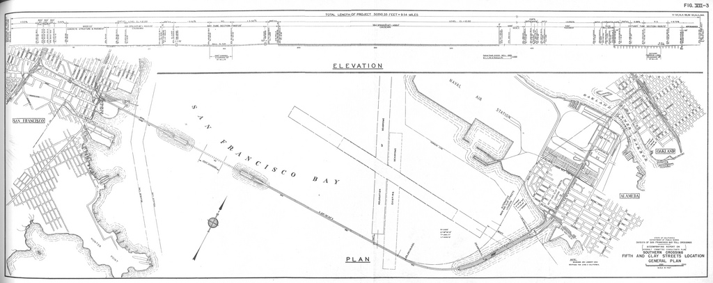
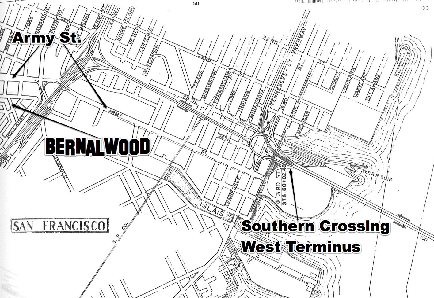
1949: California Department of Public Works map shows the Southern Crossing linked to the Bayshore Freeway via a dedicated highway, with Army Street feeding southwestern San Francisco

SouthernCrossing.1949

Check out the Army Street detail:

1949.SCdetail 2

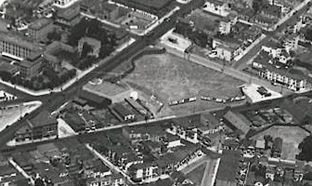
1950: Shortly before US101/Bayshore Freeway construction begins, aerial view shows the now-complete Army Street widening, and the undeveloped approach to the proposed Southern Crossing:

bernalhill1950x

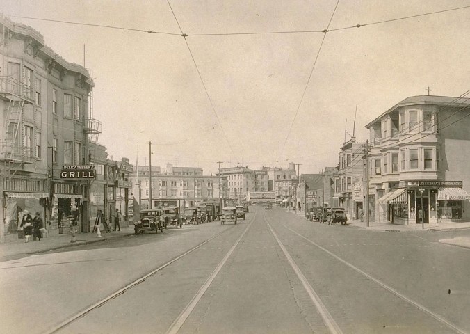
1953: Army Street, shown from street-level at South Van Ness, a few years after the Army Street widening was completed. Notice how then-and-now photos reveal that today’s nasty-ass Army St. streetscape design is basically unchanged from this time:

Then and Now: South Van Ness at Army Street, 1953

1950s: US101 converted from Potrero Avenue/Bayshore Blvd. routing to the elevated limited-access freeway. A roundabout under the Freeway connects Army, Potrero, and Bayshore.

1960s-1970s: I-280 constructed in San Francisco

1968: Steve McQueen begins iconic “Bullitt” car chase on Army Street at Bryant in Bernal Heights. Location looks just as unpretty then as it does today.

1970: San Francisco Chronicle declares “Southern Crossing Should Be Built,” arguing in favor of a “missing link the Bay Area’s traffic system” that would carry 36 percent of all transbay traffic to San Francisco, diverting 45,000 vehicles a day from downtown.

1971: Even after most other San Francisco freeway projects have been abandoned, California Freeway Planning Map still shows proposed Southern Crossing:

sffreeway1971-1

1972: Sierra Club freaks out over proposed Southern Crossing. Voters reject a bond measure to build a Southern Crossing bridge terminating in Hunter’s Point.

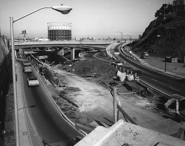
1973: Army Street/US 101 Spaghetti Bowl interchange built, replacing the roundabout that previously linked Army with Potrero Ave. and Bayshore Blvd. The new interchange was intended in part to serve traffic coming from and going to a future Southern Crossing:

army1011973

Late-1980s: No means no. Another proposal to build a Southern Crossing dies amid widespread opposition from environmentalists.

1995: Amid much grumbling, Army Street renamed Cesar Chavez.

1995-2010: Southern Crossing proposals basically dead in the water, although Diane Feinstein advocated the idea yet again in 2000. Cesar Chavez Boulevard remains very ugly.

2012: Big, sexy new sewer main installed under Cesar Chavez:

chavezpipe

2013: Work begins on Cesar Chavez Streetscape improvements intended to strike a better balance between cars, pedestrians, bikes, and adjacent neighbors (not necessarily in that order). When finished, the basic configuration will look something like this:

CesarChavezPlanview

So there you have it.

Looking back on the last 80 or so years, the unifying thread in Army/Chavez history is that, first and foremost, the street was intended to serve as a high-volume route within a regional transportation plan that envisioned freeways and a future transbay bridge as its core elements. Like Precita Creek that runs underneath it, Army/Chavez was designed to carry traffic flowing from Twin Peaks eastward toward the shoreline of the Bay.

In that sense, the conspicuous ugliness of Army/Chavez is simply part of its function, because it was designed serve as a backbone of a car-centric vision of what San Francisco’s future required.

For a whole host of reasons, that’s not quite how the future turned out. So now — at last! — Cesar Chavez is being reimagined around a different vision for a different kind of future; a future in which Chavez continues to serve as an important artery, while also doing more to serve the neighbors who use it and live near it.

Of course, that may or may not be how the future actually turns out. So check back with again us in 80 years for another retrospective.

UPDATE: Let the bonus photos begin!!

Neighbor Joel dug into his photos archives and pulled up some more Army Street gems.

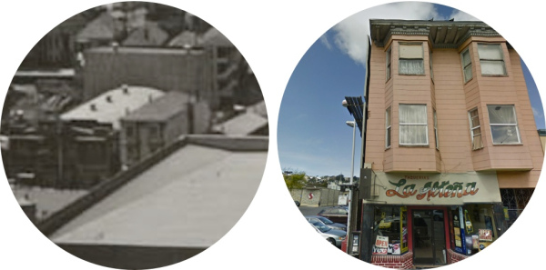
Here’s a view of Army Street during the street widening, circa 1940. Looks to me like Army at Harrison, shortly after the properties on the north side of Army were condemned and removed. (This block then became a rather notorious public housing project.) I believe the building visible just to the left and behind the (now-demolished) school-like building is the northwest corner of Army and Shotwell; that’s the same garage workshop space that’s now home to John’s Jaguar Repair:

ArmyStreet.Harrison

Google Street View confirms the location; notice the two houses on the far right:

chavezharrisonstreetview

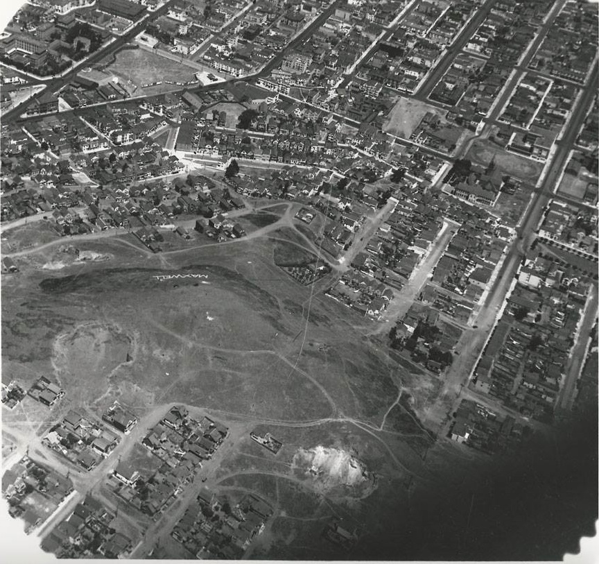
Neighbor Joel also sent a clean aerial shot of the Army-Potrero-Bayshore roundabout under the 101 freeway, probably sometime during the 1960s.

Army and 101 interchangeX

UPDATED: Vintage Photo Was Very Probably Taken from Bernal Heights

vintageView

Sarah from the Bernal Heights History Project recently posted this photo, soliciting input to help pinpoint the location where the picture was taken.

Obviously, it’s a view looking east, so that pretty much narrows it down to either Potrero Hill or Bernal Heights. Based on my own armchair historiography, I’d say it is definitely a view from Bernal Heights, likely taken sometime in the late 19th or very early 20th century.

The perspective seems just right for Bernal Hill, but the key detail, I’d posit, is the elevated railroad trestle that stretches across the photo near the shoreline, roughly following the same route used by the present-day Caltrain. The area shown is present-day Bayview, but before it was filled in (in no small part with debris from the 1906 earthquake), the area was a vast, swampy marsh — which is why the railroad was built on an elevated trestle. Let’s zoom and enhance for more detail:

vintageViewdetail

This panoramic illustration from 1868 shows the marshland of Islais Creek and the railway bridge that spanned it:

1868perspective2

So that’s my guess. Do you see any other details that might help identify where this photo was taken?

UPDATE: Bernalwood contributor Joe Thomas (who lives in a house with an east-facing view) notes that there is a warehouse visible in the vintage photo:

vintageViewwarehouse2

From where Joe sits, it sure looks like that warehouse is still there, on Hudson at Toland!

IMG_0445

Here’s the Google Streetview. Note the right-justified configuration of the doors:

peerwarehouse.streetview

PHOTO: Top, via Bernal Heights History Project

There’s a Bernal Buried in the Mission Dolores Cemetery

bernaltomb2

bernaltomb1

Neighbor Laurie made a historic discovery last weekend at Mission Dolores:

Sketching at Mission Dolores today, I was startled to see the headstone (and footstone, if there is such a word) for one of the original Bernal family that gave its name to our neighborhood.

It’s a good pilgrimage site for any fanatical Bernalwood patriots out there.

Amen. José Jesús Bernal was the son of José Cornelio Bernal, namesake of Bernal Heights and the original recipient of the land grant that included our present-day neighborhood. Wikipedia provides a handy thumbnail history:

José Cornelio Bernal (1796–1842), grandson of Juan Francisco Bernal, who was a Spanish soldier on the Anza Expedition, was also to become a soldier and married Maria Carmen Sibrian (1804–) in 1819. José Cornelio Bernal, was regidor (a member of the ayuntimiento, or town council) of San José starting in 1828. In 1834 as secularization of the Missions began, Bernal was granted 6 acres (24,000 m) at Mission Dolores by Governor José Figueroa. Rancho Rincon de las Salinas in was granted in 1839, and Rancho El Potrero Viejo in 1840. José Cornelio Bernal died in 1842, and the grant inherited by his widow, Carmen Sibrian de Bernal, and their son, José de Jesus Bernal (1829–1870).

With the cession of California to the United States following the Mexican-American War, the 1848 Treaty of Guadalupe Hidalgo provided that the land grants would be honored. As required by the Land Act of 1851, a claim for Rancho Rincon de las Salinas y Potrero Viejo was filed with the Public Land Commission in 1852, and the grant was patented to Carmen Sibrian de Bernal and José Jesús Bernal in 1857.

The family gradually sold off the land. The first portion of the Bernal grant to pass to other hands occurred in 1859, when General William Tecumseh Sherman foreclosured on a mortgage. In the 1860s the rancho was subdivided into small lots, primarily populated by immigrants who farmed the land and ran dairy ranches.

PHOTOS: Neighbor Laurie

In 1889, Bernal Heights Was a Confusing Mess of California Avenues

1889 map thumbnail

Last week, map maven Eric Fischer zapped a tweet to La Lengua’s rebel spokesblogger Burrito Justice, sending him a link to an odd 1889 map of Bernal Heights:

In addition to proving that La Lengua has always been part of the Dominion of Bernalwood, the map showed a certain lack of creativity among those who took it upon themselves to name the streets in those days.

On this 1889 map, present-day Coleridge, Mirabel, Shotwell, Esmeralda (from today’s park eastward), Peralta (north of Esmeralda), and Holladay were all called California Avenue. There are even three places where one California Avenue intersects another California Avenue.

1889 map annotated

It’s also a reminder of the tendency of planners to try to impose street grids onto terrain that makes building straight-line streets impossible — a folly which has resulted in the disconnected un-streets seen in another recent Bernalwood post.

I wrote about that phenomenon’s effect on Peralta Avenue last year, and I happen to live at one of the former intersections of California and California (Peralta and Esmeralda).These “paper streets” were a persistent feature on old maps, even as the names of the aspirational streets changed.

In this 1924 map, California Esmeralda goes over the top of Bernal Hill:

Despite the lines on the map, that part of Esmeralda remained wisely unbuilt when Harrison Ryker took aerial photos of Bernal Heights in 1938:

By 1948, unbuilt “paper streets” (map via Eric Fischer again) were shown as dotted lines:

Such visionary views of Bernal Heights are always good for a few knowing chuckles and “what-ifs.” Yet if you think it’s hard trying to get a cab or order a pizza today if you live on an odd stretch of Esmeralda, just imagine how much worse it would have been if you had to give directions that involved a delivery to the intersection of California and California.

What Year Was the Party to Celebrate Bernal Hill Becoming a Park?

bernalparkcelebration

This photo has been floating around the Interwebs for a few weeks; it’s a poster/handbill for an event to commemorate the dedication of Bernal Hill as a proper park — in contrast to the mining quarry/ad hoc garbage dump/motocross track that it had been before.

Turning Bernal Hill into a park was definitely a good excuse for celebration, and it looks like the party happened in grand style, with kite-flying, balloons, clowns, and … bagpipes.

But there’s just one problem; it’s not clear what year it was when this happened. There’s a small, penciled-in “1973?” notation in the top-left of the image above, and there’s some corroboration of that year on the old website of the San Francisco Parks Alliance:

Then it was time for Bernal Heights Park- the hill with 26 acres of open grasslands lying between a telephone company’s microwave tower at the top and Bernal Heights Boulevard below. It belonged to the Department of Public Works. In 1972, the Recreation and Park Commission voted to transfer the land to itself to protect it from possible development. Bernal Heights residents, who had pushed for the change, gathered at McLaren Lodge and cheered. Recognizing that Rec and Park had postponed the transfer because the department lacked funds for maintenance, they agreed not to seek capital improvements for the next several years. And in June, 1973, with soaring kites and bouquets of balloons, officials dedicated what one called, “the last and biggest city-owned space available for a park.”

Another clue comes from the date; it turns out, June 10, 1973 really was a Sunday.

Yet while the evidence to support a 1973 date is compelling, we’d rather hear it from a first-hand witness. So… were you in Bernal when the hill formally became a park? Do you recall what year it was when the neighborhood erupted in celebration and bagpipes at the top of Folsom? Do tell!

Bernal Heights Writer Publishes the Definitive Short History of the High-Five

Bernalhifive2

You may recall that earlier this week Bernalwood encouraged one and all to give Neighbor Markus a high-five for all the hard work he’s done recently to reinvigorate the Flickr online photo service.

Now we would also like to encourage you to give Bernal Heights writer Jon Mooallem a high-five,  for writing an authoritative and very satisfying history of… the high-five!

Neighbor Jon published his article on ESPN last month. The quick version of the story is that the high-five was invented by…

Actually, the tale is too good to ruin with a quick version. You should really read the whole article. But here’s how Neighbor Jon describes the reporting process that accompanied his history of the high-five:

I started looking into the origin of the high-five for a “live issue” of  The Magazine, produced with the folks at Pop-Up Magazine and performed on stage in New York in the spring of 2011. At the outset, the project seemed straightforward, even easy. I couldn’t have been asking a simpler question — Who invented this thing? — and I already knew a bit about [basketball player] Lamont Sleets. Or at least I thought I did. But once I started investigating, it was as if a trap door opened at the center of the story and I was sent whooshing down through it, and from there, through a dizzying system of pipes and chutes, then more pipes and chutes, until I finally looked around and realized I’d landed somewhere — somewhere that just happened to feel like a perfect ending. The other day I was talking to a journalism class and the students asked me how I went about reporting this story. I told them I had no idea.

Again, read the whole thing.

Then, if you see Neighbor Jon, definitely give him that high-five — not only for his awesome article about the high-five, but also for his brand-new book, Wild Ones: A Sometimes Dismaying,  Weirdly Reassuring Story About Looking at People Looking at Animals in America.

ILLUSTRATION: By Bernalwood. Bernal photo by Telstar Logistics; High-Five via ESPN

Remembering the Great Bernal Heights Gold Rush of 1876

Bernal.Eureka One of the more charming and ridiculous episodes in Bernal Heights history concerns the Great Bernal Heights Gold Rush of 1876. Seriously! There really was a mini-gold boom on Bernal Hill in the late 19th century, and while it lasted barely a month, it generated all the attendant hype and breathless boosterism that was so typical of the era.

Burrito Justice, La Lengua’s rebel spokesblogger, wrote about the Bernal Heights Gold Rush in 2010. Now Evelyn Rose has followed-up with a new post about it on her geekolicious history blog, Tramps of San Francisco:

EUREKA! Gold! Gold in Bernal Heights!

The first land sold in Bernal Heights had been transferred by auction at the real estate offices of H.A. Cobb and R.H. Sinton, 102 Montgomery Street, on July 14, 1860. The property consisted of “4, 5, and 6 acre lots on the ‘Bernal Heights’ … within 15 minutes drive from City Hall … for sale at a very low rate … The lands, for beauty of locality, commanding scenery and fertility of soil, are not surpassed in the county of San Francisco.” In August 1865, another 66 homestead lots were offered in on the “Cobb Tract” of Bernal Heights and buyers were to receive title and a U.S. patent. In 1863, the original St. Mary’s College for boys was established on the Old Mission Road by the first archbishop of San Francisco, the Most Reverend Joseph Sadoc Alemany. The campus would move to Oakland in 1870, and in later years to Moraga where it is found today.

Yet, despite all of the homesteading, it would not be until May 1876 when the first report of an “alleged gold-bearing ledge” on Bernal Heights appeared in a small legal note in the Daily Alta California. One might suspect that the discoverer, Victor Bessayre, secretary of the Cedar Hill Consolidated Mining and Milling Company in Virginia City, Nevada (home office at 120 Sutter Street in San Francisco), had the savvy and know-how to appreciate what he had found. Soon after, a second 1500-foot location was “claimed” by Payot, Upham & Co., publishers, booksellers, and stationers in San Francisco, adjoining the northwestern edge of Bessayre’s claim.

Soon, word of the find became widespread and the masses embarked on a feverish San Franciscan Gold Rush. As told by a Daily Alta California reporter:

“Out Folsom street, over a romantic bridge which spans the creek, the ascent of Bernal Heights is begun. The grade is very steep by this route, and frequent stoppages are made in order to rest and view the landscape, which, by the way, is well worth the struggle. Soon you meet persons returning from the gold region, nearly all bearing away specimens of worthless red rock with some quartz sprinkled through it. Some shout ‘we have a sight,’ others ask ‘got a prospect?’ while others say ‘no need of going further, boys, all the claims are located.’ After half an hour of weary struggling against the wind and stones, and over the short slippery grass, the ascent of the first and smaller hill is accomplished.

“After resting a moment, an unexpected sight greets you. Fully five hundred people, consisting of men of all ages, from the very aged to the beardless youth, women gayly [sic] attired, children sporting about under the lee of the larger hill – which towers 100 feet above – engaged in various occupations. Most of the men are in possession of small hammers, and are busily engaged breaking the rocks in pieces in vain attempts to find the precious metal. The women and children are seated on the rocks, digging and pecking away, expecting a rich find. After walking around and examining a few specimens in the hands of some lucky gold-hunters, you come across some boards stuck up, resembling a real estate sign, but much smaller, on which is nailed a notice that the parties therein named have located 1500 feet, bearing from the site, in such a direction so far, and so on to place of commencement, with all the dips, spurs, etc.

“Some speculative individual, with an eye to business, has started a beer shop, consisting of a rude table, underneath which there is gracefully placed two beer kegs, and on top sundry glasses and a free lunch. A short distance down from the summit of the hill you notice our glorious standard, the ‘Star-Spangled Banner,’ floating in the breeze, and are attracted toward it and find an itinerant peddler, who thinks there is money in it. He has a small stock of fruit and other edibles …

“… On all their faces you can see enlarged eyes and glowing countenances, whether arising from the difficulty in making the ascension, or the expectancy in securing some favorable location which may become a source of profit to them …

“… The better time to make your visit to the gold regions would be in the forenoon, as the wind does not blow and it is clear. As we turn about to make the descent we notice large numbers on the way up the trail, others going down, which would remind you of a large ant-hill, with its little people going back and forth in their daily labors. With streaming eyes and running nasal organs we clutch our hats in one hand and our kerchiefs in the other, and with tears in our eyes, which are hastily wiped away – not caused, don’t think, by regret as to what we are leaving behind – we are forced into a rapid run, caused by the steep grade. We are comically gazed upon by the inhabitants of the Heights, while we in turn wonder at their leaving so much gold undiscovered for so long a time. Once in a while we gain a level place in pause. On reaching the base of the Heights, we meet anxious squads of twos and threes, just commencing the ascent, who anxiously enquire the way to go, and wish to know if we have any specimens. Recrossing the bridge, we once more regain the vicinity of horse-cars, and other conveniences. Almost every car which arrives at the terminus lands some gold-hunter, who makes the trip and returns, weary and hungry.”

Of course, as Burrito Justice pointed out while recalling this same tale, gold had not been discovered on Bernal Hill. Instead, it seems that Victor the Frenchman had found quartz.

Side Note: There seems to be some disagreement on Victor’s proper name. Tramps of San Francisco calls him Victor Bessayre, but Burrito Justice calls him Victor Resayer, and there is an entry for a Victor Ressayer at the same 120 Sutter St. address in the 1876 San Francisco Directory:

VictorRessayer

Regardless, the dream of finding precious rock in Bernal Heights proved enticing to the
proto-hipsters of the Mission District, as Tramps of San Francisco goes on to explain:

The Bernal Heights diggings appeared to have become quite a topic in the young City. In June of 1876, part of the advertised weekend amusements at Woodward’s Gardens included acts by Thomas Beavans, the Campanlogian; Mademoiselle Clarissa, the Parisian Velocipedist; Blanchette, the Excelsior Contortionist; and, “An elaborate 20-stamp quartz mill will … be operated on some Bernal Heights ore.”

The news of the diggings reached as far as the southland, as the Los Angeles Herald reported:

“Bernal Heights, the scene of the recent quartz discoveries, was visited on Friday by a large number of people, including many California street men. Several additional claims have been staked out, and work will be commenced on some of them to test the question. The whole neighborhood is in a state of excitement.”

Arguably, that “state of excitement” has endured to the present day. Special thanks to Tramps of San Francisco for granting permission to excerpt here on Bernalwood.

Time Travel: The View Northwest from Bernal Hill, circa 1907

BernalNW1906 Well, this is convenient.
Last week, the Bernalwood Office of Signals Intelligence detected a
tweet
from @sfhistorian
which contained a rather awesome
photograph taken from Bernal Hill in the early 1900s, circa 1907.
The photo shows the view looking over today’s La
Lengua Autonomous Zone
, toward Noe Valley and Twin Peaks.
It has great resolution. It reveals tons of interesting historical
detail. It made Bernalwood’s imaging analysts smile. Unfortunately,
writing up a post about a photo like this takes a great deal of
time. Fortunately, La Lengua propagandist Burrito Justice also
found @sfhistorian’s tweet, and it compelled him to do a very
thorough geek-out on the image
… so I don’t have to.
Yesssssssss. Thus, under the terms of the
Bernal-La Lengua Treaty of Common Historical Reciprocity, we are
pleased to recommend a few highlights from the Burrito
Justice study of the c. 1907 photograph
. We begin with
this annotated version of the original image, created by
Bernalwood’s Tactical Graphics Unit: BernalViewNW1906-6 Burrito Justice provides
this detail of the railroad trestles for the Southern Pacific
Railway running south along Dolores toward the Bernal
Cut
: sprr-rail-trestles Some zooming and
enhancing
reveals the future Rock Bar, looking more or
less the same, but less rocky than today. 1907-rock-bar The former Lyceum Theater
stands next to today’s La Alteña Taqueria: 1907-la-altena Burrito Justice uncovered
a jaw-dropping quantity of sordid tales about the tenants of the
former Railroad Hotel that stood at 24 Tiffany Street: 1907-railroad-hotel The building was later
called the Cable House, and the character of its residents was
typified by this incident from 1906: 1906-24-tiffany-rose-carey A great deal more
unseemliness took place at the Cable House, and Burrito Justice has
lots more to enjoy. Finally, there are telling details about
parking conditions in early twentieth century Bernal Heights, where
residents clearly didn’t worry about hitching their horses in
curbside red zones on Prospect Street (perhaps because there were
no curbs). Unfortunately, we can’t tell from the photograph if
passive
aggressive parking notes
had been slipped into the
horses’ bridles: 1907-bernal-horses Seriously though, Burrito
Justice did some amazing sleuthing to reveal the many stories
this one photograph has to tell, so don’t confine yourself to this
Bernalwood greatest hits summary. Go
read the whole original thing!
PHOTOS: Original
image, via Calisphere.
Inset detail photos and maps, by Burrito Justice. Annotated photo
by Bernalwood, with hints from Burrito Justice.