
The photo above (Thanks Mark!) shows a view of Cesar Chavez Boulevard looking west from Folsom in 2008, a few years before the current/ongoing sewer and streetscape improvement project got underway. As you can see, it is very unlovely.
In the comments to Monday’s item about the removal of the ugly-ass, freeway-style road sign across Cesar Chavez Boulevard, Neighbor Andy was prompted to wonder how Cesar Chavez Boulevard became so awful and so highway-like in the first place.
The short explanation is simple: Cesar Chavez — formerly Army Street — WAS designed to be a highway. Sort of. The wide thoroughfare as we now know it was carved out in the 1930s and 1940s, with the intention of using the road as a major east-west route to carry automobile traffic, first to the US101 Bayshore Freeway (which was built in the early 1950s), and eventually to the Southern Crossing, a second transbay bridge that was planned to terminate in the area around Army/Chavez and Third Street.
Wait. A second transbay bridge??? At the foot of Army/Chavez?? WHAT??!!
Follow along as we take a quick survey of Army Street history, give-or take a few years here and there:
1859: Here, Precita Creek runs unfettered down the present-day Cesar Chavez Boulevard corridor, providing a primary route for water drainage for the eastern slopes of Twin Peaks. It also functions as a sewer. Present-day Precita Avenue shadows the route of the former Precita Creek. Army Street not created yet, but Navy Street ran parallel:

1888: Precita Creek still a creek. Army street is a jankey east-west road that runs alongside it:

Circa 1900: Precita creek channeled underground, Army street built on top
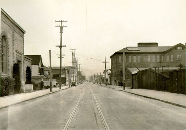
1931: Check out this amazing view of Army Street, looking west from Harrison, when it was a relatively normal San Francisco City Street (with a streetcar line!). That’s Le Conte Elementary School (now, Leonard Flynn) on the left, with the St. Anthony’s church steeple behind it. The church burned in the 1970s.
1936 and 1937: Bay Bridge and Golden Gate Bridge open to traffic.
Late 1930s: Army Street widened from a normal 4-lane city street to an 8-lane surface throroughfare. This is why many of the houses on the street are so close to the curb, with no front yards. Eminent domain is a bitch.
1940: View west on Army at Harrison again, showing both widened and unwidened portions. The caption on this photo hopes “the city soon may have the money to finish the widening.” Good times.

1940s: Flush with bridge-building ardor and postwar can-do, Southern Crossing bridge proposed.
1947: Here’s a view looking south from Potrero Avenue at the Army Street intersection. That’s Bernal Heights in the top right, with the stairs leading up to Holladay. The US101 freeway was built here 10 years later.

1948: A Southern Crossing was envisioned as part of an urban freeway network that would have encircled Bernal Heights in a maze of concrete viaducts, including one that followed Mission Street:
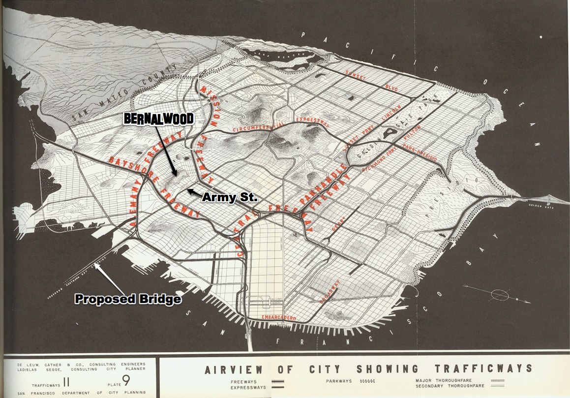
This scenario is so grim that we must zoom and enhance to see how bleak it really was (while also admiring the map’s realistic attention to geographic detail). Note the Army Street interchange on the proposed Mission Freeway, at the western end of Precita Avenue. Oh my:

1948: Here’s another view of the City’s proposed freeway network, showing more clearly how Army Street would have played an important role as an east-west artery to the Southern Crossing (and how thoroughly all of this would have sucked for Bernal Heights):
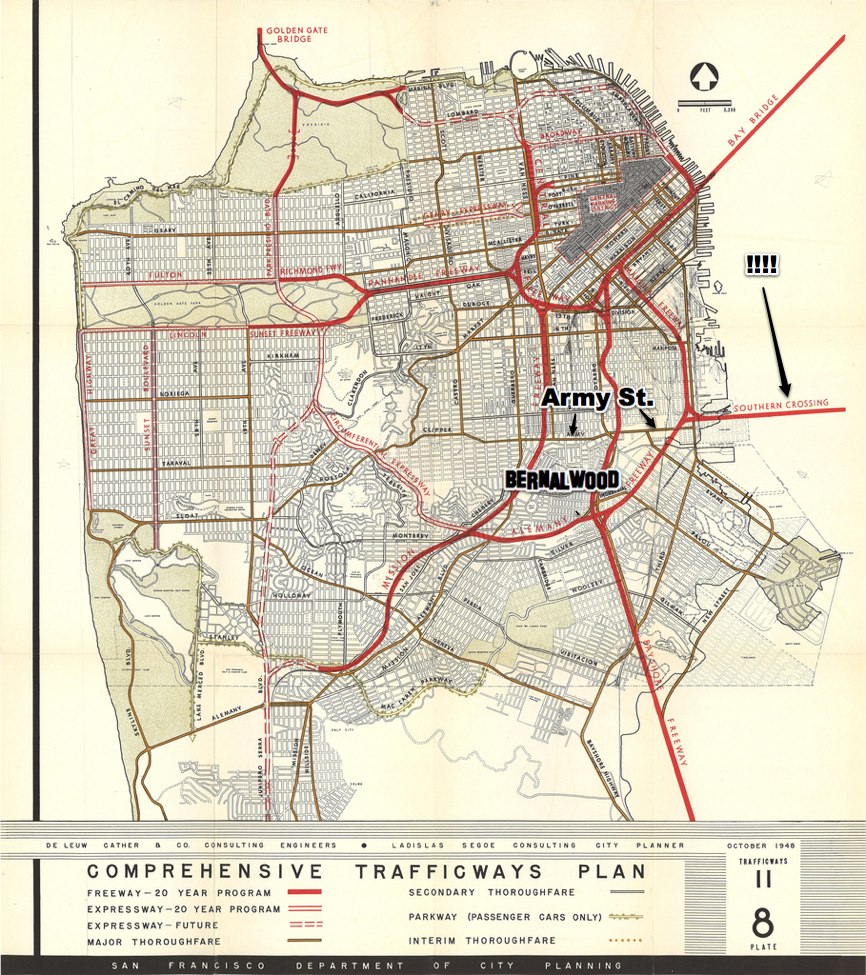
1949: California Department of Public Works map shows the Southern Crossing linked to the Bayshore Freeway via a dedicated highway, with Army Street feeding southwestern San Francisco

Check out the Army Street detail:
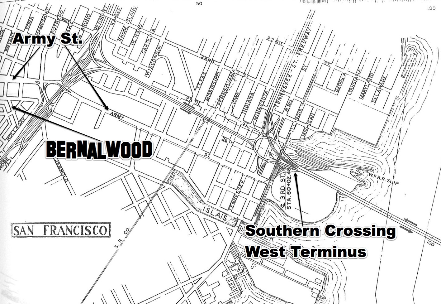
1950: Shortly before US101/Bayshore Freeway construction begins, aerial view shows the now-complete Army Street widening, and the undeveloped approach to the proposed Southern Crossing:

1953: Army Street, shown from street-level at South Van Ness, a few years after the Army Street widening was completed. Notice how then-and-now photos reveal that today’s nasty-ass Army St. streetscape design is basically unchanged from this time:

1950s: US101 converted from Potrero Avenue/Bayshore Blvd. routing to the elevated limited-access freeway. A roundabout under the Freeway connects Army, Potrero, and Bayshore.
1960s-1970s: I-280 constructed in San Francisco
1968: Steve McQueen begins iconic “Bullitt” car chase on Army Street at Bryant in Bernal Heights. Location looks just as unpretty then as it does today.

1970: San Francisco Chronicle declares “Southern Crossing Should Be Built,” arguing in favor of a “missing link the Bay Area’s traffic system” that would carry 36 percent of all transbay traffic to San Francisco, diverting 45,000 vehicles a day from downtown.
1971: Even after most other San Francisco freeway projects have been abandoned, California Freeway Planning Map still shows proposed Southern Crossing:

1972: Sierra Club freaks out over proposed Southern Crossing. Voters reject a bond measure to build a Southern Crossing bridge terminating in Hunter’s Point.
1973: Army Street/US 101 Spaghetti Bowl interchange built, replacing the roundabout that previously linked Army with Potrero Ave. and Bayshore Blvd. The new interchange was intended in part to serve traffic coming from and going to a future Southern Crossing:

Late-1980s: No means no. Another proposal to build a Southern Crossing dies amid widespread opposition from environmentalists.
1995: Amid much grumbling, Army Street renamed Cesar Chavez.
1995-2010: Southern Crossing proposals basically dead in the water, although Diane Feinstein advocated the idea yet again in 2000. Cesar Chavez Boulevard remains very ugly.
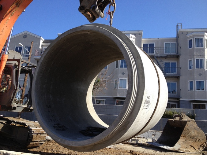
2012: Big, sexy new sewer main installed under Cesar Chavez:
2013: Work begins on Cesar Chavez Streetscape improvements intended to strike a better balance between cars, pedestrians, bikes, and adjacent neighbors (not necessarily in that order). When finished, the basic configuration will look something like this:

So there you have it.
Looking back on the last 80 or so years, the unifying thread in Army/Chavez history is that, first and foremost, the street was intended to serve as a high-volume route within a regional transportation plan that envisioned freeways and a future transbay bridge as its core elements. Like Precita Creek that runs underneath it, Army/Chavez was designed to carry traffic flowing from Twin Peaks eastward toward the shoreline of the Bay.
In that sense, the conspicuous ugliness of Army/Chavez is simply part of its function, because it was designed serve as a backbone of a car-centric vision of what San Francisco’s future required.
For a whole host of reasons, that’s not quite how the future turned out. So now — at last! — Cesar Chavez is being reimagined around a different vision for a different kind of future; a future in which Chavez continues to serve as an important artery, while also doing more to serve the neighbors who use it and live near it.
Of course, that may or may not be how the future actually turns out. So check back with again us in 80 years for another retrospective.
UPDATE: Let the bonus photos begin!!
Neighbor Joel dug into his photos archives and pulled up some more Army Street gems.
Here’s a view of Army Street during the street widening, circa 1940. Looks to me like Army at Harrison, shortly after the properties on the north side of Army were condemned and removed. (This block then became a rather notorious public housing project.) I believe the building visible just to the left and behind the (now-demolished) school-like building is the northwest corner of Army and Shotwell; that’s the same garage workshop space that’s now home to John’s Jaguar Repair:

Google Street View confirms the location; notice the two houses on the far right:

Neighbor Joel also sent a clean aerial shot of the Army-Potrero-Bayshore roundabout under the 101 freeway, probably sometime during the 1960s.


This is a tour de force, Todd — very impressive. Thank you for the lesson.
Thank you to the hippies of yesteryear for defeating the freeways and saving the top of Bernal Hill!
Very cool! Gotta say it’s a shame that the Southern Crossing bridge was never built, though I wouldn’t want it feeding directly onto Cesar Chavez.
I like that the proposed Southern Crossing was going to split in the middle of the bay and cross over Alameda in 2 places. They were certainly going to get screwed! But hey we could have gotten to Oakland Airport in no time!
I just made a 20 minute short film named People Live Here on this very topic. Coming to film festival near you soon 😉
You made that?! Some friends of mine saw this in Seattle and were raving about it.
Hi ! So far I’ve only shown it at a private screening for my graduate class in Santa Cruz and to a few folks. If they saw it and raved- awesome! I’m happy to report it became official this evening- People Live Here is having it’s public premier on Sunday September 1st at the bernal heights outdoor cinema festival.
Come see the history and future of Cesar Chavez on film!
Impressive work. Very Impressive.
The only Southern Crossing we need is another Transbay Tube. I envision a Forest Hill type station on Cortland.
That won’t help us get to the Seadromes shown on the map, though!
The Southern Crossing plan is nightmarish in its details: they were basically proposing to do to Bernal Heights exactly what I-105, I-710, I-110 and CA-91 did to Compton down in LA. San Francisco’s southern half would have been turned into an unrecoverable slum for decades.
Remind me to send the Sierra Club some extra money and a thank-you card.
Great piece. I still reflexively call it Army St. and have to correct myself when giving directions, which I actually enjoy. And yes, bravo to defeating freeways around the hill, but I must say, the idea of another bay crossing is tantalizing, if it could be done in a way that minimizes encroachment. Could the Candlestick point area work? Either way, great piece.
Wow, great piece Todd. Thank you.
Fantastic piece, Todd! This lays out how we got here in clear, fascinating detail!
One of the best Bernalwood posts ever. There were several things in it that I didn’t know. And while I’m glad the original plan wasn’t built, the idea of a Southern Crossing connected to 101 and 280 may well have some merit in relieving traffic in SF. Not that I ever expect to see it in my lifetime, especially after the financial/engineering cock up that is the Bay Bridge retrofit.
Recent news events prove that the next Bay crossing trend is small boats with dog runs in the middle.
This was fascinating – thank you, Todd!
Thank you. Tremendous post.
It’s Third and Colusa, not Third and Army. Sheesh.
Excellent post.
Awesome story! Now if only there were only some way to get the present day freeways surrounding Bernal torn down…
Better yet: build a wall around Bernal and keep everyone else out!
Weeeeell, I am not for that as I like my Noe Valley Paxti’s pizza delivery too much but if we can tear down freeways to improve SOMA and Hayes Valley, then we can tear down freeways to improve Bernal, Portola, MIssion…
what a great story, thank you!
I used to work with a stubborn old-timer who, when giving directions, would refer to the intersection of Cesar Chavez and Third Street as Army and Kentucky. In 2007. He grew up on the West side of Bernal and before some streets were paved, his summer jobs were managing the dust and grades of his neighbors driveways.
Army Street in SF before widening was complete:
Army Street intersection with 101 when it was a roundabout like at Alemany:
I’ve never posted photos in a comment before so I hope this works!
Thanks, Todd, for including my photos in your update! (They didn’t transmit here.) Sadly, I’m not actually a Bernal neighbor. I’ve lived in the Western Addition most of my life. But as a Thinkwalks researcher, I get fun things sent to me. The aerial view was sent to me by Pete Tannen, retired Bike Program Manager for the former SF DPT.
And while I’m piping up again, let me comment about the Southern Crossing promoters: More car space?! Just begets more car use. Ugh.
Unfortunately the new Cesar Chavez will just have crappy narrow bike lanes where you’re sandwiched between opening car doors and high speed traffic. They should have used some of the median space to add the protected bike lanes that other cities like New York, Chicago, and Memphis are putting in.
Truth.
I wasn’t a part of the process on designing this project, so I know I have little right to complain, but I probably still will. An improvement is great, but yeah, a stepping-stone to truly awesome bike infrastructure. I’m unclear about soft-hit posts here, but that would be great. I’m hoping the traffic-calming will go a long way to make cycling on that street less scary…
I agree, San Francisco isn’t built for bikes to many cars, buses, and one way Streets! To dangerous for driving and biking in SF!
Pingback: Today’s Headlines | Streetsblog San Francisco
In 15 years they will probably be digging up Precita Creek from its fancy new sewer to follow the new trend of reopening urban watercourses. Actually I kind of wish they had done it this time.
The process is already beginning, actually, though it’s unclear if it’ll get anywhere or if it’ll consider Precita Creek. I have an appointment next week to be an advisor to a consultant to a consultant to the SF PUC to discuss this very topic, with regard to waterways that lead toward Mission Bay. Precita creek hasn’t been part of Mission Bay watershed for a long time. But it was, back before the erosion at the east end of Bernal grabbed its flow.
Little known fact: part of Precita Creek is already a surface creek closely matching its original natural state. Go to Cuesta Court, just above the T-intersection of 24th St and Grand View Ave under the Market Street overpass. There’s a gush of water (one of the springs that make up the Precita Creek headwaters) flowing year-round as a spring. This spring is likely the main reason that this stretch of Market is up on an overpass. It then flows as a small surface creek for a hundred and some feet before going over the Grand View curb and into the sewer. There are lots of visible smaller seeps in the area, but this one tops them all.
There seems to be a permanent seep where Chavez goes under 101 too. Another remnant of the creek.
Jack/Joel–as someone who has dealt with what seems to be the annual seepage of Precita into the underpass where Cesar Chavez peels off 101, would love to see a plan from the PUC that made some attempt to deal with the problem rather than simply put band-aids over the large potholes that invariably sprout up around March/April. Either set the Creek free or do a better job of containing it (and not wasting taxpayer money on expensive annual band-aids) PUC!
no_vally: From my conversation today with the consultants, it seems that there’s a plan—likely to stay just a plan in my opinion. The plan is to build an insanely expensive long term solution that consists in a deep tunnel that acts as a drain to all sorts of flooding areas on the eastern flats of SF. As I say, I think it’s not too likely to happen, but who knows. The band-aids may be cheaper.
Absolutely wonderful piece Todd. Many thanks.
In December, 1947, neighbors on Chavez and Guerrero and San Jose Avenue, went to hearings in City Hall to protest being evicted for the widening of Chavez west of Harrison, and Guerrero/San Jose south of Chavez. They lost. The Chronicle carried the story.
Yeah, but think about how much fun it would have been to drive on all those never-built freeways. I Still miss coming off the Bay Bridge and zooming around on the Embarcadero Freeway to Broadway (get a hold of Koyaanisqatsi for video). Making the reverse trip gave you tremendous view of the bay. It was also great fun to drive down the final hill on Gough, catch all the green lights, and zoom up to the top of the cross-town freeway past the city hall dome.
Thanks, great piece of history and news. Great “edition” all around.
There are stubs for the ramps that would have gone to the southern crossing on I280 exit @ army st, and a “bulb out” for the on ramp on the upper deck.
In the first black & white photo of Army and Harrison photo in the update section the school building is/was Cogswell Polytechnical College. it moved out in the 70s
Oh, so that southern crossing is where that design for the new cantilevered suspension Bay Bridge came from:
* http://www.lib.berkeley.edu/news_events/bridge/up007.html
Nice. Thanks. You say that Flynn is on the right. I think you mean the left, South.
Enviado desde mi móvil. Discúlpense la brevedad y los errores tipográficos. El inglés no es mi lengua materna — o así a veces parece.
El ago 14, 2013, a las 11:31 a.m., Bernalwood escribió:
> >
Doh! Fixed. Thanks.
Long Live Army Street!
And Cesar Chacez yesterday morning http://instagram.com/p/dHc1gmAxT-/
Great article – thank you.
Is it just me or does the current construction project seem to be about the worst run affair on SF’s streets? The contractor has done a horrible job re-striping where necessary, and installing signage warning about ending lanes, etc.
great piece! can we repost it on FoundSF.org? it’s a perfect history piece…
Yes, of course!
Now if we could only get some attention directed toward Bayshore Blvd.
“It Will Always Be Army Street”
I agree!
Todd, that was definitely among one of you very best articles in here. You clearly did the work and then some. I remember the famous “spaghetti bowl” because as a boy I would follow it since each time its height would alter. I remember my father driving me in his station wagon among the labyrinth of wild knots of to be freeway that was being raised from what was then a simple and easy to drive flat road before the start of the 101 construction. It was like driving in the wild west for the detours were confusing making it every driver for her/himself.
So much so that if a policeman stopped you, “one would just sign the citation because the explanation of the violation was itself impossible to understand,” I’d hear my father bellowing under his breath as he gingerly would pull away with my eyes still zoomed on that “spaghetti bowl” the entire time hoping to eye-witness its rising or falling.
And as a final thought, Todd in the early seventies the entire hill was intentionally set a blaze every summer in a controlled environment via the SFFD. It would hold much debris that was also charred (I suppose it was less costly than to physically remove it with manpower). I clearly remember that each fourth of July that would arrive, the fire trucks would also pay us a visit. How can any six year old boy forget such an event firetrucks and all?
I would watch from the same house I sit here today, the only difference? I was a boy of six years young (never any cars around as one see’s there today). Ah, you knew I “had” to would throw that one in.
And I remember when cars were allowed all the way around the hilltop and weekend nights the west end was filled with r teenagers, car stereos blasting and a pile of empty beer bottles and cans in the morning.. Those were the days!
In the 4th and 5th photos, you can see the Poetsch & Peterson Tannery at 3112 Army near Harrison, across the street from Le Conte Elementary. The students used to go on field trips to view the tannery. There are some interior photos of the tannery here:
http://www.leathersmithe.com/poetsch–peterson-san-franc.html
The interior of St. Anthony Church on Army Street looked exactly like St. Boniface Church at 133 Golden Gate Ave with magnificent stained-glass windows and huge marble columns. Both churches were constructed by German immigrants who came over during the Gold Rush. There are some remarkable interior photos and articles about how St. Boniface serves as a sleep sanctuary for the homeless:
http://www.sfgate.com/bayarea/article/Project-Gubbio-at-St-Boniface-sanctuary-of-sleep-3407103.php#photo-2621648
http://www.mintpressnews.com/poverty-the-new-slavery-in-the-us/24928/
Pingback: Balkanize Bernal | Burrito Justice
Pingback: Three Long-Lost Views of Army Street at Midcentury | Bernalwood
Pingback: What You Missed When You Missed Glenn Lym’s Talk About the Lost Geology of Bernal Heights | Bernalwood
Pingback: Wednesday: Cesar Chavez Ribbon-Cutting to Celebrate Our Sexy New Infrastructure | Bernalwood
Pingback: SFHomeBlog.com – A San Francisco Real Estate Blog » Blog Archive » Cesar Chavez Ave Improvement Project Honored
Interesting history lesson, thanks! Bernal was definitely saved! Unfortunately for those of us who live on the southwest corner of Potrero and surrounding blocks, all of this “great urban planning” left us with Potrero Street and the Army/Bayshore/101 “loop” feeling like industrial freeway hell anyway!
Pingback: SFHomeBlog.com – A San Francisco Real Estate Blog » Blog Archive » Liveable SF: Big Plans for Potrero Avenue
Pingback: Extremely Sexy, Extremely Short Raised Bikeway Coming to Part of Our Part of Valencia Street | Bernalwood
Pingback: Glen Park Neighbor Proposes Simple Plan to De-Uglify the Bernal Cut | Bernalwood
Pingback: Change in plans | Smart Growth America
to me,it will always be Army Street