Viva La Contra-Revolución! La Lengua Dissidents Dislike Funny Name, Seek to Rejoin Dominion of Bernalwood

Bernal1889.map3

Fellow Citizens of Bernalwood, this is a day we’ve long awaited.

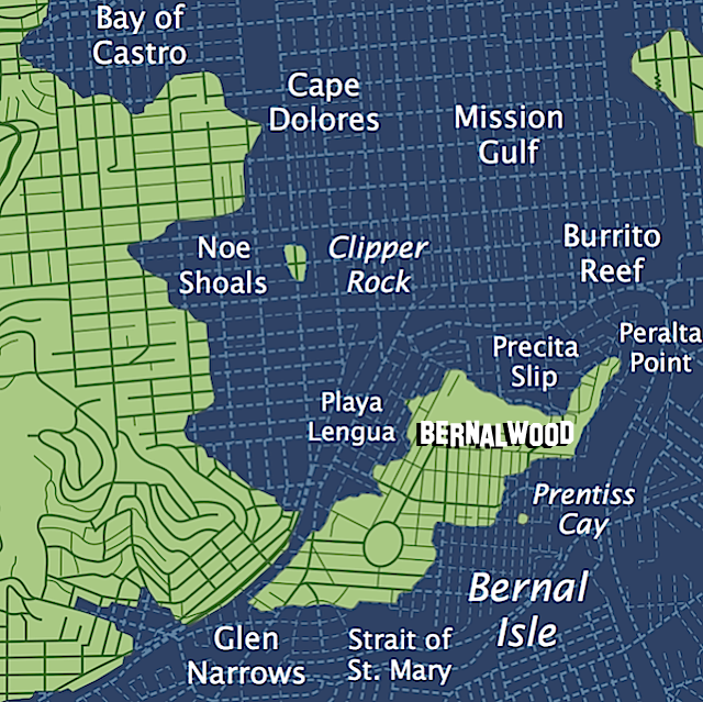
We have endured years of rebellious bluster and seditious propaganda seeking to undermine the integrity of the Bernal Heights motherland. Yet we now have indications that the La Lengua separatist movement may be collapsing under the weight of its own geopolitical absurdity.

Last week, the Greater Bernalwood Signals Intelligence Unit received this encrypted communication from Neighbor Lisa, who resides deep within La Lenguan territory:

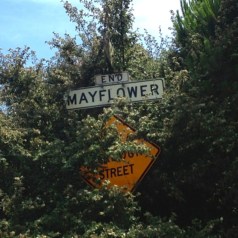
My neighbors and I have a problem. We have been saddled with an absolutely awful nickname for our little corner of San Francisco (La Lengua) and we don’t know how to get rid of it.

The blogosphere, including your esteemed and oft quoted blog, seems to think it is a great term, but the only person on our block who likes it is Burrito Justice himself. Every time someone shares a link to an article containing the hated term, our street mailing list fills up with emails suggesting alternatives. Even when the article is about a pot smoking bear, people get more excited about That Name.

We’d be happy to be referred to as Bernal Heights at this point.

So, how do we get people to use a different name for our microhood? I actually have some pretty strong feelings about what we should call my ‘hood, but unfortunately nobody likes my suggestion as much as I do. Anything but La Lengua.

And yes, every good revolution needs a splinter group.

Rest assured, Lisa, the Citizens of Bernalwood will be happy to welcome you back into our nurturing embrace!

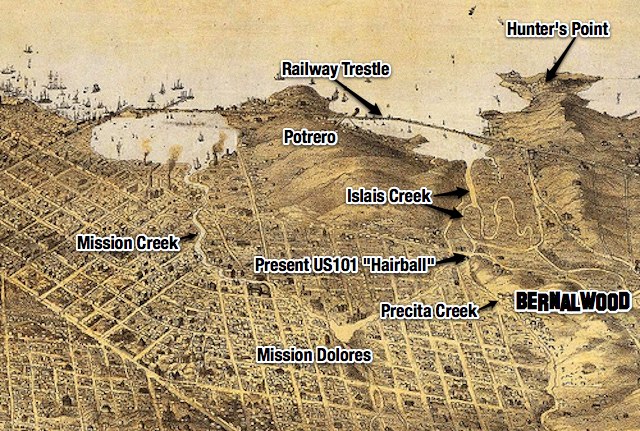
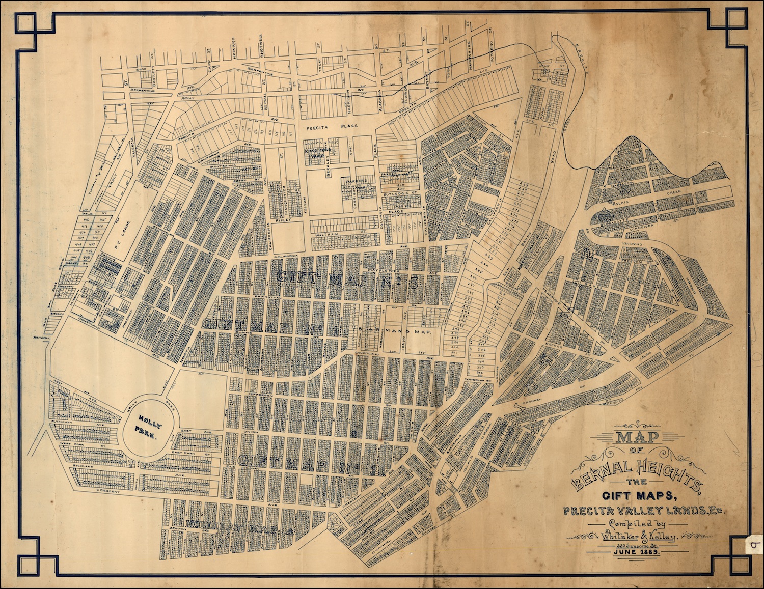
IMAGE: Historic map from 1889 clearly includes the so-called La Lengua territories with the geographic boundaries of Bernal Heights. (On the other hand, this same map also includes six different streets named California Avenue, so draw your own conclusions.)

Beautiful New Map Shows Bernal Heights, Even More So

bernal.topourbanismFast Company Design carries a story about a new map of San Francisco that  happens to include a particularly tasty representation of Bernal Heights:

In San Francisco Contours, a topographical print by Abe Bingham … urbanity has been stripped away to highlight the hills of the city.

The piece was inspired by a combination of San Francisco’s unique landscape and the general failings of traditional topographical maps, which are, on one hand, a triumph of data visualization, and on the other, very difficult for the average person to decipher. As a fix, Bingham built his maps in full 3-D, exaggerating altitude by 2.5x to simulate the view of a pedestrian rather than a flyby.

The map is gorgeous, but the exaggerated proportions make it somewhat difficult to orient yourself to the image of Bernal Heights shown above. So here’s an annotated guide:

bernal.topourbanism.edit

Abe Bingham is a SF-born graphic designer, and he wants to sell images of his maps, so you can find out more (and buy a copy) on his Kickstarter page. A $50 contribution qualifies you as a “Bernal Hill Level” donor, which is actually rather flattering.

IMAGES: Via Abe Bingham

Census Visualization Reveals Racial Geography of Bernal Heights

SF.2010census2

Dustin Cable is senior policy researcher and statistician with the Demographics & Workforce Group at the University of Virginia’s Weldon Cooper Center for Public Service. He recently completed a “Racial Dot Map” that uses data from the 2010 census to illustrate “geographic distribution, population density, and racial diversity of the American people in every neighborhood in the entire country.”

Each dot represents one person, with each race shown in a different color. The result is a vast, visual map that Wired calls “the most comprehensive map of race in America ever created.”

The image above is the racial dot map of San Francisco. The resolution of the interactive version of the dot map is limited, but we can zoom and enhance to get closer look at Bernal Heights:

Bernal.2010census.overlay

Innnnnnnteresting.

There’s an impressive amount of mixing going on here in Bernal, even as there are also some very clear patterns of clustering. What you see here could quite literally be described as a kind of ethno-geographic Rorschach Test.

So shall we discuss? Let’s discuss.

MAPS: via the interactive Racial Dot Map

Ye Shall Walk These Bernal Streets, And Know They Are (Still) the Steepest

bradfordsteepsx2

Waaaaaaay back in 2011, Bernalwood posted an item about an independent researcher who had concluded that, despite some “official” lists which claim that the steepest streets in San Francisco are in Nob Hill and Noe Valley, the actual data indicates that four of the City’s eleven steepest streets are right here in Bernal Heights.  As we concluded at the time:

Bernal Heights may not always be the smartest, or the prettiest, or the most popular neighborhood in the world. But we may rest secure in the knowledge that we will always be the steepest.

Well, it’s two years later, and now 7×7 Magazine has taken another look at the data to determine which City streets are the steepest. And once again, according to writer David LaBua, the streets of Bernal Heights are the steepest in town, capturing the number 1, 3, 4, and 6 slots:

bernalhillslope

So Bernal’s reign of urban verticality continues. But what’s it like to actually live at the top of Bradford, which is now reaffirmed as the steepest of the steep streets in all of San Francisco? Neighbor Lupe tells it:

As the owner of the last house on Bradford, both my legs and my car brakes can attest to the cliff-like steepness of the street. Most of my friends have “mastered” coming up the hill, and a few have learned to drive up in reverse to simplify getting back down. I marvel at Recology, UPS and FedEx rambling up and down with nary a care. Some of the postmen appear as if they are ready to have a coronary, some are clearly athletically inclined, barely breaking a sweat after reaching the “summit”. Not sure how the Chronicle finds its way here, but the paper sits on my doorstep every weekend, neatly wrapped in its bag. The foot traffic increases on Saturdays and Sundays, and it is easy to see who has not ventured up the hill in the past – the lenghty pauses and wide-eyed look on the faces of these virgins is easy to spot.

IMAGE: Top, Bradford’s 41% grade. Photo by Data Pointed

Bernal Isle Resort: A Modest Proposal for the Future of Bernal Heights

bernalisle

bernalisle.plan

This week, the New York Times reports that scientists believe global warming could cause up to three feet of sea-level rise by the year 2100.

With sea levels rising, we must look forward… many, many, many years forward, to envision a future in which the oceans have risen 200 feet and reclaimed much of San Francisco — except for Bernal Heights, which will enjoy many natural advantages as a post-urban island with wonderful beachfront real estate.

It may take centuries for Bernal to attain its island destiny. Yet whenever that future arrives, we, the residents of Bernal Heights, should ourselves be the architects and authors of our shared destiny. Which is why — aided by detailed maps of Bernal Isle created by La Lengua rebel leader Burrito Justice — Bernalwood has developed some conceptual mockups to demonstrate how we might leverage Bernal’s prime beachfront location overlooking Mission Gulf… for the benefit of posterity.

As you can see, the central element of our proposal is the development of the luxurious Bernalbleu Hotel and Resort near the site of present-day Folsom and Ripley Streets:

Bernalbleu3

The northeast end of Bernal Isle will be the ideal location for a premium residential enclave, with convenient access to watercraft and prime views of San Francisco’s majestic Submerged Skyline. With its own on-demand ferry service, Prentiss Island just off Bernal’s South Shore could be an exclusive haven for a select group of high-value homeowners:AlabamaYC2-1

On the west side, the gated community of Hipster Vista will serve a younger clientele that prefers a more active lifestyle. The Cortlandia Shopping District will be a thriving retail corridor, with merchants specializing in the sale of fudge candies and resusable hemp-fiber shopping bags decorated in the local style. Localsonlyville will be where many year-round residents live, and it shall nurture the spiritual core of Bernal identity.BernalIsleWest

Of course, Bernalwood understands that change is difficult.

We also understand that dramatic change is even more difficult, especially when it comes in the form of 200′ sea level rise and the redevelopment of Bernal Heights as a Catalina-style island resort destination.

Yet change is coming — whether we like it or not. That’s why we propose to look change right in the eye, pour it a stiff drink, and give it a big, wet minty-fresh kiss. Let’s begin to prepare for tomorrow… today! All ideas are welcome.

Is This the Bernal Heights of Tokyo?

kikunabernal

tokyoBernalwood

Nate Hill is traveling in Japan, where he says he has stumbled upon a Bernal-like neighborhood just south of Tokyo, near the Kikuna train station:

natehilltweet

I’m a confessed Tokyophile, but I don’t have any insight as to what’s the most Bernal-like part of greater Tokyo. So if anyone dissents from the above, or has a better proposal for the “Bernal Heights of Tokyo,” please chime in.

Regardless, my expectation is that the Bernal Heights of Tokyo will have inferior hilltops but superior ramen.

Trendspotting City Blog Discovers That Bernal Is For Lovers

OLYMPUS DIGITAL CAMERA

As Citizens of Bernalwood, we all know that Bernal Heights is for lovers. It’s been our little romantic secret.

Well, now every starry-eyed Millennial from The Marina to Capp Street knows it too, thanks to a recent listicle on the SFist blog that documents “10 Best Unique Dates in SF.”

Bernal Hill was second on the list (right behind that vista at Land’s End):

Bernal Hill
The top of the hill in Bernal Heights is an unsung gem of the city. And given that it takes some travel to get there, and is decidedly more off the beaten path than, say, Twin Peaks, makes it an ideal makeout spot, especially on a clear and non-windy night. We’d suggest bringing along some mulled wine, or port, or a nice Chianti.

Mulled wine? Nice Chianti? Is that what the kids are calling it these days??

On the bright side, Bernal locals know those recommended “clear and non-windy nights” are actually rather unusual, and that gusty exposure and oceanic chill are hardly conducive to amorous enthusiasm the rest of the time.

So the Citizens of Bernalwood probably need not fear this SFist item will trigger the arrival of  Chianti-swilling youth hordes seeking a chic, secluded place to consummate their Bang With Friends hookups.

At least not yet.

PHOTO: by Dyche

Hidden Part of Bernal Heights Looks Oddly Like Rural France

bernalfrance

Last year, Bernalwood showed you a secret part of Bernal Heights that actually looks a lot like Alabama.

Now, in the photo above, Neighbor Ed Brownson captured a secret part of Bernal Heights that actually looks a lot like rural France. And the funny thing is, the Alabama-like place and this France-like place are only a few hundred yards apart.

And where are these mysterious Bernal places that look sort of like Alabama and sort of like rural France, right here in the heart of San Francisco?

Let the Guess Where Games begin.

PHOTO: Ed Brownson

UPDATED: Vintage Photo Was Very Probably Taken from Bernal Heights

vintageView

Sarah from the Bernal Heights History Project recently posted this photo, soliciting input to help pinpoint the location where the picture was taken.

Obviously, it’s a view looking east, so that pretty much narrows it down to either Potrero Hill or Bernal Heights. Based on my own armchair historiography, I’d say it is definitely a view from Bernal Heights, likely taken sometime in the late 19th or very early 20th century.

The perspective seems just right for Bernal Hill, but the key detail, I’d posit, is the elevated railroad trestle that stretches across the photo near the shoreline, roughly following the same route used by the present-day Caltrain. The area shown is present-day Bayview, but before it was filled in (in no small part with debris from the 1906 earthquake), the area was a vast, swampy marsh — which is why the railroad was built on an elevated trestle. Let’s zoom and enhance for more detail:

vintageViewdetail

This panoramic illustration from 1868 shows the marshland of Islais Creek and the railway bridge that spanned it:

1868perspective2

So that’s my guess. Do you see any other details that might help identify where this photo was taken?

UPDATE: Bernalwood contributor Joe Thomas (who lives in a house with an east-facing view) notes that there is a warehouse visible in the vintage photo:

vintageViewwarehouse2

From where Joe sits, it sure looks like that warehouse is still there, on Hudson at Toland!

IMG_0445

Here’s the Google Streetview. Note the right-justified configuration of the doors:

peerwarehouse.streetview

PHOTO: Top, via Bernal Heights History Project

A 60-Second Tour of Esmeralda Avenue, As Mapped (But Never Built)

Esmeralda plan 1924

Last week’s post about the confusing number of California Avenues in late 19th century Bernal Heights maps prompted an excellent suggestion from La Lengua’s rebel spokesblogger Burrito Justice:

Challenge accepted!

I stayed as close as I could to the original line of Esmeralda without breaking my neck or breaking-and-entering. Actually, I could have gotten a little closer at Peralta by walking the camera through my own apartment; I figured that would’ve been jarring. But I have taken a few stationary time-lapses out my front window, looking west on Esmeralda.

Up at the top of the hill, paper Esmeralda would have gone through the Sutrito Tower fence, or south of it, but I went north in order to hook up with the trail to the Esmeralda steps.

Here’s the final Esmeralda video:

Bernalwood’s favorite tree/shrub/pet cemetary makes an appearance at 0:15-0:18, and the Esmeralda slides appear at 0:54.

The easternmost “block” of Esmeralda, above Holladay and below Brewster and Franconia, is nearly impassable, so I cheated by zooming in and out from either side. A neighbor on what would have been the corner of Esmeralda and Holladay helpfully pointed me to the fire hydrant that marks the end of paper Esmeralda:

So enjoy the complete, contiguous, Esmeralda Avenue. Also available in animated GIF form:

Esmeraldaing2

In 1889, Bernal Heights Was a Confusing Mess of California Avenues

1889 map thumbnail

Last week, map maven Eric Fischer zapped a tweet to La Lengua’s rebel spokesblogger Burrito Justice, sending him a link to an odd 1889 map of Bernal Heights:

In addition to proving that La Lengua has always been part of the Dominion of Bernalwood, the map showed a certain lack of creativity among those who took it upon themselves to name the streets in those days.

On this 1889 map, present-day Coleridge, Mirabel, Shotwell, Esmeralda (from today’s park eastward), Peralta (north of Esmeralda), and Holladay were all called California Avenue. There are even three places where one California Avenue intersects another California Avenue.

1889 map annotated

It’s also a reminder of the tendency of planners to try to impose street grids onto terrain that makes building straight-line streets impossible — a folly which has resulted in the disconnected un-streets seen in another recent Bernalwood post.

I wrote about that phenomenon’s effect on Peralta Avenue last year, and I happen to live at one of the former intersections of California and California (Peralta and Esmeralda).These “paper streets” were a persistent feature on old maps, even as the names of the aspirational streets changed.

In this 1924 map, California Esmeralda goes over the top of Bernal Hill:

Despite the lines on the map, that part of Esmeralda remained wisely unbuilt when Harrison Ryker took aerial photos of Bernal Heights in 1938:

By 1948, unbuilt “paper streets” (map via Eric Fischer again) were shown as dotted lines:

Such visionary views of Bernal Heights are always good for a few knowing chuckles and “what-ifs.” Yet if you think it’s hard trying to get a cab or order a pizza today if you live on an odd stretch of Esmeralda, just imagine how much worse it would have been if you had to give directions that involved a delivery to the intersection of California and California.

These Bernal Heights Streets Are Barely Streets at All

joyst

rosenkranz

mayflower

faithst

Neighbor Craig has been admiring some of the feral streets of Bernal Heights; streets so small, or so wonky, or so disjointed that it’s dubious whether they deserve to be called streets at all. Take it away, Neighbor Craig:

I’ve been thinking about the least Street Streets of Bernal Heights.  Here are my current favorites:

Joy – one block long, only stairs, but many lovely cottages on those stairs. Next street over is Faith. Paradoxically, the rest of Joy was eliminated when the 101 freeway was built.

Esmeralda – About three blocks – not connected, mysteriously runs between Lundy’s and Prospect, then Winfield and Elsie on the Northwest Slope, mysteriously reappears on near the top of the northeast slope for one block connecting Alabama and Franconia with barely a curve to signal the start and end. At one point the street turns into a SLIDE.

Waltham – basically a driveway for 2 houses near the top of Alabama, one of which is listed on VRBO.

Emmett Ct – A sliver of an alley with 3 houses off of Precita

Heyman Ave – 5 houses between Coleridge and Prospect. It’s a SMALL block, but a real street
Rosenkrantz – Famous for being a random sign with no apparent street or even stairs on the southern stretch of Bernal Heights Blvd. However, there are legitimately 5 houses on this street once you dive over a guard rail and dirt road to find it.

Mayflower – I dare you: Just try to find it. ONE house in all of Bernalandia has this street address, but the place where the street possibly lies is actually about 4 short blocks long!

Special recognition goes to Peralta for holding the title as the least contiguous street in Bernal, breaking six times over its course as it winds from the Alemany Farmers Market and ends in a scary stairway 50 feet directly above the Cesar Chavez/101 Hairball.

PHOTOS: Craig Sakowitz

Counterpoint: A Lifetime Resident Laments the Transformation of Bernal Heights

beenevicted

Bernal Heights is changing.

Is that a good thing or a bad thing?

Actually, Bernal Heights has been changing for about 180 years.  Change is often difficult, yet my sense is that the changes that have taken place here during the last decade or so are particularly unsettling to the generation of residents that came of age in Bernal roughly between 1970 and 1990.

Neighbor Orlando is one of those residents, and since I have great respect for his perspective, I  also appreciated his comments in response to a recent Bernalwood post about the transformation of Bernal Heights into an enclave for the so-called “Creative Class” (though he just as easily could have written it in response to the data which shows that Bernal real estate prices are going up, up, up.)

Neighbor Orlando writes:

Bernal Heights originally was a village made up of blue collar, very low educated immigrant families that moved here because they could not afford to live in many other areas of the city. I bared witness to such because my parents were of this class as many of their neighbors also were.

The last time I checked, a home in this neighborhood sold for one-million dollars. This must have made my father roll over in his grave. No home on the hill was ever of such extreme value during the sixties up here. As a matter of fact, it was quite the opposite considering that the hill was a wasteland of debris due to the fact that many San Franciscans would use it as place to dumb old odd size household goods such as mattresses, ceramics tubs, toilets, and wooden furniture.

So rugged a hill it once was, that I as a young boy learned to ride a motorcycle; a honda 50cc that my father bought me one christmas “motorcross” style on many of the trails still visible today! Yes, you read rightly, one once was able to ride a motorcross cycle on that hill.

Todd, I am curious to ask you when was the last time you met a low income non-english speaking family move in recently? I believe you have met many of the original dwellers moving out since this is one of the overall goals of this recent gentrification that is popular for real estate values.

After all, is it not true that before such a movement (when bernal was predominantly made up of these uneducated, non-english speaking middle class families) the prices of homes were indeed affordable to someone whose job was to clean upper middle class homes or work as a baggage handler at SFO?

This is hardly the case when a home on the same property sells for one million dollars. The same block of land ten times more the costs simply because folks that clean houses or work as baggage handlers have recently moved away so that these creative scientist, lawyers, and managers can move in. Who by the way, are not likely to be of negro or hispanic ethnicity.

I only ask that if you truly cannot see this Todd, that the next time you meet the new family on the block, you check off my list to see if this new family fits the Bernal enclave that it once was for many, many generations. Myself included.

Good fodder for discussion. So, dear and respectful neighbors, let’s discuss.

PHOTO: A recent billboard modification on Cortland, photographed April 30, 2012 by Andrew