Soviet Invasion Forces Uninterested in Bernal Heights

La Lengua separatist and rebel spokesblogger Burrito Justice recently found an interesting Cold War-era map of the San Francisco Bay Area that was produced by military cartographers in the former Soviet Union:

The Soviets (good god, that sounds weird now) went to town mapping the world for their Cold War needs. This particular SF map is 200000:1, but they detailed some cities to 25000:1, and others down to 10000:1, highlighting tank-friendly roads and important buildings.

The excerpt shown above (click to enlarge) suggests that Bernal Heights might have fared relatively well during a Soviet ground invasion. Notice, for example, that Cortland Ave. was not recommended as a tank-friendly transport route, while the Sutrito microwave telecommunications tower is not highlighted as a militarily significant structure.

So we’ve got that going for us.

IMAGE: Via Burrito Justice

A Rare Diesel Machinery Sighting on Bernal Hill

As you know, Bernalwood routinely carries news about strange creatures spotted on Bernal Hill. Today neighbor Ken found two large and unusual specimens in the wild:

Another day in paradise. This big baby got through the Bernal gate for a retaining wall project on the street below.

Judging from the white coloration and bold display of plumage, this would appear to be a male Levo Telescopicus. A female Vehiculum Gravis was observed not far behind, bearing a load of ferrous material:

PHOTOS: Neighbor Ken

Newfangled Gas Pump Converts Sunlight Into Text Messages

Just in time for tonight’s glamorous Summer Solstice Stroll, a clever new fixture has been installed in front of the exceedingly clever New Wheel Electric Bicycle Shop on Cortland.

As you no doubt recall, The New Wheel sells newfangled electric bicycles that make it easy to pedal up Bernal Hill without really breaking a sweat. The bikes run on batteries, and the batteries need recharging, and recharging requires electricity. So our newfangled bicycle shop has installed a newfangled solar-powered recharging station out front, to recharge bicycle batteries.

The solar pump will also be available for use by all the Citizens of Bernalwood as a refueling stop for our luxurious personal electronic devices.

The pump on Cortland was custom-built by Sol Design Lab, and it’s the same solar -powered recharging pump that was last seen hanging out inside the fence at Hayes Valley Farm:

The SolarPump Charging Station is a self-contained island of free solar power available for the public to charge any electronic device (electric bicycles to cellphones and laptops, etc.) using a standard 110v AC plug. The bus stop-sized station inspires conversation about energy consumption, solar power and growing adoption of electric mobility.

The SolarPump was originally envisioned to combine a repurposed American car culture symbol (a 1950s Citgo gas pump) with an interactive display harnessing solar energy to charge electric bikes and mobile electronics.

The station has standard 110v outlets, so anyone can walk up and charge a cell phone, laptop, electric bike or scooter. The power is collected by Sanyo Bifacial solar panels on the roof of the station.

Finally! No longer will you have to worry about running out of juice on Cortland as you send text messages while batch-processing photos to send by email as you upload your star-sighting videos to YouTube and geolocate all your friends within a 500′ radius! Right??? If all that gets to be just too much for your poor little battery, rest assured that you can now use the SolarPump to perk back up.

Just remember: It’s BYOC (Bring Your Own Cord).

PHOTOS: Telstar Logistics

Precita Park and Playground Begin Super-Sexy Makeover

The venerable and much-beloved Precita Park just keeps getting better. But even better things are on the way.

Neighbor Demece, ringleader for the  fabulous Precita Valley Neighbors, brings us an update:

The Precita Park improvements have begun!

Here is a general timeline:

New grass seed has already been planted in the middle of the park, so we’ll have a greener and less muddy park when the rain come again.

June 5 – June 15th, the asphalt trail along the west side of Preicta Avenue will be repaired. This will make it possible for everyone to walk along the trail, and the acacia tree roots that have been breaking up the pavement will be protected.

June 15 – July 15th, the Children’s Playground will be closed for improvements. The improvements are: providing new ground cover under the swings and slide area, tire swings, and picnic tables. The ground cover under the swings and slide area will be a blue/black speckled single rubber platform. The will be a granite platform under the picnic tables. The crazy deadly rubber squares under the tire swing will be a green/black speckled single rubber platform. A water fountain will be installed inside the Playground near the Alabama Street gate. A community kiosk will be installed near the picnic tables. The community kiosk will be a source of information put out by local non profits. The Helen Diller Playground in Mission Dolores Park has one, if you would like to see what it looks like. All the playground structures will be repaired; for example, the planks leading to the wiggly bridge will be replaced. All the structures and sand areas will remain the same. We will get new sand, and we will help shovel it out of the trucks. After the structures are repaired, we will help choose paint colors for the structures. We will help paint the structures. The penultimate satellite spinner stays. No one messes with the penultimate satellite spinner. New signage will also identify the rules of the Childrens’ Playground, similar to the Helen Diller Playground. But then, they don’t have the penultimate satellite spinner. And we do.

And we are immensely grateful to the Community Opportunity Fund, the magical Jake Gilchrist, our fantastic Regional Parks Supervisor Eric Andersen, John Miller our hard working Regional Manger, and Brian our fabulously cool park gardener for making this all beauty happen before our very eyes.

Want to find out more? Or, want to thank Demece for making all this happen? (She’d never tell you that.) The next Precita Valley Neighbors meeting happens on Saturday 6/16 at 9:30 am, at Charlie’s Cafe on the west end of Precita Park.

PHOTO: Precita Valley Neighbors

Work Begins (and Artists Wanted) for New Bernal Library Mural

If you visited Cortland Street this weekend, you might have noticed the new scaffolding that surrounds the Bernal Heights Branch Library. The remuraling of the library is now set to get underway:

The waiting is over! Implementation of Phase One will proceed as follows:

JUNE 8-9 set up scaffolding

JUNE 11 City building maintenance crew will start the three-week job of prepping and painting the exterior walls facing Andover, Cortland, and Moultrie.

FIRST WEEK OF JULY Artist Rueben Rude will commence work on the Moultrie Street mural.

END OF AUGUST Moultrie Street mural will be completed.

JULY AND AUGUST Precita Eyes will install the tile and bronze artwork on the Cortland Street (front) wall. The logistics of creating tiles and bronze foundry work make it impossible to be absolutely precise about the timeline of this installation, but Precita Eyes is doing everything possible to finish by the end of August.

HELPING The Task Force is working with the artists to identify opportunities for the community to participate. If you’re interested in helping out, let us know by email. And we will also be back in touch when we have more information from the artists.

Meanwhile, Neighbor Brandon tells us that the Bernal Library Art Project has issued an invitation for artists to submit proposals for the southern, playground-facing side of the library building:

Seeking proposals for exterior artwork on the playground side of the Bernal Heights Branch Library in San Francisco (500 Cortland Avenue).

The library was constructed in 1939 and is a significant landmark in the community. Interior renovation of the library was completed last year, and all the facilities are new and enlarged. During the last year, new artwork has been designed for the front façade and Moultrie side of the library and will be installed this summer.
The final exterior artwork for the playground wall of the library should be visually compelling and dynamic, preserve the aesthetics of the building, express the values of the community, and enhance the experience of the programs and resources offered by the library.

The new artwork will incorporate themes of social justice, inclusion, Bernal history, represent the whole community and be reflective of the artist’s particular interpretation. The new art will be designed to create a balance between the artwork and the facade—freestanding, mural, or some other combination. It will use media that requires little or no maintenance, such as painted tile, mosaic, or metal work. It will also need to create a dialogue with the artwork on the front and Moultrie side of the library.

For an application email bernallibraryartproject@gmail.com

PHOTO: Telstar Logistics

The Right Way to Dispose of Big Stuff (Hint: Don’t Just Leave It Outside)

Dumped mattress in Bernal Heights

Why do this when Recology will take it from your curb at no extra charge?

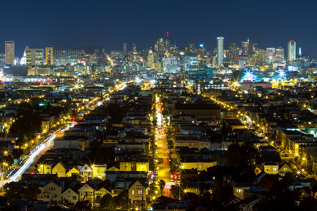
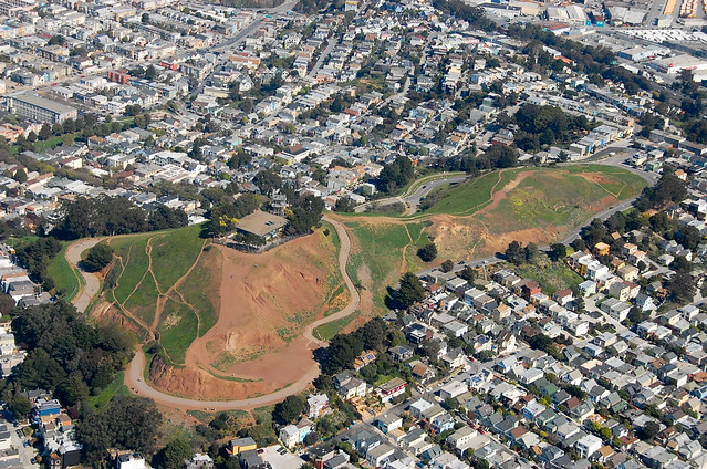
It goes without saying that the citizenry of Bernalwood was outraged by the recent rash of dumping incidents on Bernal Hill.

But while we’re on the topic of dumping, the Bernalwood Research Department has uncovered an interesting litter-related fact: The majority of the 20 million pounds of abandoned crap our cash-strapped city cleans up every year, to the tune of four million dollars, does not come from piles of construction debris left by miscreants skulking about under cover of darkness.

Nope. “The bulk of what we pick up is innocent household items just set out on sidewalk,” says Greg Crump of the Department of Public Works.

We’ve all seen this kind of small-scale dumping: that splotchy mattress slouching against the side of a building, or that lopsided media cabinet optimistically adorned with a “Free” sign in the mini-park.

Which means that some inhabitants of our fair dominion are, apparently, doing it.

Not that you ever would, of course. But if you happen to see or know of anyone whose idea of spring cleaning is leaving their oversize clutter on the sidewalk, please spread the word: THERE IS A BETTER WAY, and it’s EASY.

Just go to RecycleMyJunk.com or call 330-1300 and tell the fine folks at Recology Sunset Scavenger what you’ve got and when you want them to haul it away. (I recommend calling, despite the annoying recording you have to listen to, because even if you fill out the online form, you’ll still have to call later.)

Why expend the very minimal effort required to do this?

Reason #1: It’ll probably be free, because—get this—if you have garbage pickup, you’re already paying for this service (more on that later).

Reason #2: Your stuff is less likely to end up in the landfill. Over 60% of what Recology collects is recycled, public relations manager (and Bernalwood resident!) Robert Reed told me. “If you illegally dump, you’re creating an environmental problem,” he says. “Let’s say you abandon a mattress. How long before a dog comes along and lifts a leg, or it rains? If it gets moldy or something, at least part of that thing is going to just get tossed.”

Properly-disposed-of mattresses, by the way, are taken to … the largest mattress recycler in North America(!), a place called DR3, which happens to be in the East Bay. Between 85 and 90 percent of each mattress DR3 gets its hands on finds a new life, including the wood, the steel springs, and the outside material. “The foam gets turned into carpet padding, and a portion of the cotton actually ends up in the oil industry, to help clean up oil spills,” says DR3 manager Robert Jaco.

Reason #3: You won’t be inviting yet more blight to our glamorous neighborhood. Nuff said.

But what if you don’t have any bulky-item pickups left? This can happen. If you live in a single-family home, you’re entitled to two collections of up to 10 big items a year at no extra charge. If you live in a multi-unit building, you only get one.

But not to worry! If you’re out of curbside collections and you can’t sweet-talk your neighbor into letting you share one of theirs, you can still schedule a pickup. It won’t be free, but it won’t break the bank either. And if you can’t or don’t want to schlep your cast-offs to the curb, Recology will handle the lugging. “We collect stuff from garages,  houses, storage rooms,” Reed says. “We even carry mattresses right out of the bedroom.”

A bevy of free options exist for getting rid of non-broken furniture, appliances, etc. The Salvation Army has a conveniently close drop-off location at 26th and San Jose, but you can also have them come to you. United Cerebral Palsy of the Golden Gate will also come to you — and they send also trucks to our neighborhood every few months to pick up usable items and even e-waste; watch for their flyers in your mailbox to get a heads-up.

But whatever you do, don’t just abandon your stuff outside, or the dumping terrorists have already won!

PHOTO: Bronwyn Ximm

A Stoneman Connection Links Bernal Heights to Levon Helm

The death of Levon Helm, the former lead singer for The Band, late last week prompted a lot of media remembrances, yet the most interesting one I read was an oral history of the The Band’s signature song, “The Night They Drove Old Dixie Down.” Levon Helm sang the lead vocals in the song, of course, but here’s a version of it from “The Last Waltz” in case you need a refresher:

Anyhow, back to that excellent oral history of “The Night They Drove Old Dixie Down.” This passage jumped out at me:

[“The Night They Drove Old Dixie Down”] was the track that came to be seen as most typical of The Band album. Levon sings the song in the persona of Virgil Caine, a Confederate ex-soldier who served on the Danville supply train until General Stoneman’s Union cavalry troops tore up the tracks. The Richmond and Danville Rail Road was the main supply route into Petersburg where Lee’s Army of Northern Virginia were holding their defensive line to protect Richmond.

Stoneman was a pretty obscure character. You have to get into detailed histories of the Civil War to find him mentioned.

David Powell

General George Stoneman, c. 1860

In the closing days of the war, Major General George Stoneman, as the commander of the East Tennessee district, oversaw a raid by a division of Union troops across the rugged Blue Ridge Mountians into northwest North Carolina and southwest Virginia. Their orders were not to fight battles but to punish and demoralize the Southern civilians. Stoneman, having previously served under General Sherman in the Georgia campaign, had learned Sherman’s methods of “total war”– the concept of targeting civilian as well as military objectives in order to destroy the enemy’s will to resist. Stoneman’s cavalry troops were still exacting revenge on the Southern civilians at the time that General Robert E. Lee was surrendering at Appomattox. Stoneman’s forces plundered & destroyed tons of supplies, including foodstocks & grain, along with miles of railroad supply tracks. Even after the shooting war ended, they assisted in chasing down and capturing Confederate President Jefferson Davis. After the war, Stoneman remained in the regular army until he retired in 1871 at the rank of Colonel. He moved to California and lived on a large estate called “Los Robles” near Los Angeles. As a Democrat, he held several public offices and was Governor of the state from 1883 to 1887. Stoneman died on September 5, 1894 in Buffalo, New York. Even though Stoneman, on the surface, may appear to be just a footnote in the history of the Civil War, in that part of the U.S. where the borders of Tennessee, North Carolina & Virginia meet, his name lives in infamy. The exploits of his plundering cavalry troops in the last days of a defeated Confederacy are still a part of local legend. In this respect, I feel that Robbie Robertson succeeded in capturing this sentiment accurately in the song. 

I hadn’t realized that part of the song referred to an actual historical figure, and I immediately wondered if there was any connection between the Stoneman that Levon Helm sang about and the street by the same name in Bernal Heights.

Thanks to our excellent friends at the Bernal History Project (and their webpage devoted to the history of Bernal Heights street names), the answer soon became clear. Bernal’s Stoneman Street is indeed named after the same person:

Stoneman Street
A West Pointer who came to San Francisco in 1846 as a lieutenant in the Mormon Battalion, George Stoneman (1822-1894) was a career military commander with an uneven record in numerous Civil War campaigns. A major general, he freed the prisoners at Andersonville and led cavalry raids into the Confederacy. After leaving the Army, he settled in the San Gabriel Valley and was elected California governor, 1883-87. Camp Stoneman, a 2,500-acre Army base opened in 1942 near Pittsburg in Contra Costa County, was the jumping off place for more than a million troops headed for the Pacific Theater in World War II. It was later the separation center for soldiers returning from the Korean Conflict. The base was shut down in 1954. The cavalryman’s name was remembered in a different context when The Band, in a 1970 song by Robbie Robertson, included this couplet: Virgil Caine is the name, and I served on the Danville train/Till Stoneman’s cavalry came and tore up the tracks again.

In addition, let us not forget that Gen. Stoneman also leant his name to the chairlift that carries skiers and snowboarders up Bernal Hill’s steep north face. There’s no evidence in the historical record that Stoneman himself ever actually skied here, but even if he did, I very much doubt that The Band would have written a song about it.

PHOTOS: Top, mr.nunez.sfo, via Flickr. Gen. George Stoneman, via Wikipedia

Photographer Makes 280-101 “Spaghetti Bowl” Look Delicious

The Entry Veins of San Francisco

Photographer Toby Harriman has taken what may well be the definitive photo of the 280-101 Spaghetti Bowl in southeast Bernal. You can see it above: A crisp, long-exposure shot taken last week that animates the flow of traffic in vivid arterial detail.

When I see this photo, I also gain a new appreciation for why “Spaghetti Bowl” is such a perfect name for this interchange. Admittedly, I’m a pastaphile; but to me this picture looks like perfect strands of al dente spaghetti threading through an endless river of tangy marinara sauce. I’m not exaggerating when I say that Toby’s photo triggers a Pavlovian response whenever I look at it. Yum.

Equally delicious, if somewhat less Pavlovian, is the ultra-crisp and sparkly photo Toby took that same night looking north from atop Bernal hill:

Pick Your Route

Really, you must look at the photo in supersize to appreciate how much texture it contains. (HINT: The street in the center of the image is Alabama.) This view is familiar to us all, yet this perspective reveals details you probably have never seen before.

Bravo, Toby, and thanks for sharing your glamorous images with Bernalwood.

PHOTOS: Toby Harriman 

Revised Maps Illustrate Final Bernal Hill Trail Restoration Plan

Slides and notes have now been posted from last week’s meeting about the San Francisco Recreation and Park Department’s Bernal Trails Project.

I wrote up my own notes last week, but I was waiting for Rec and Park to release their map of the final trail proposal, which you can now see above. I made a Google Earth overlay of the previous version of the map, so… here’s an update! (KML, requires Google Earth.) As noted in the earlier post, Google Earth’s terrain model is somewhat lacking in detail, but it nevertheless illustrates the proposed changes with more dimensionality than a flat map.

I tried to match these screenshots to a couple of the gorgeous photos from the Bernalwood Air Force’s recent aerial reconnaissance mission. This pair shows the proposed new north-slope trail alignment:

NOW:

Above Bernal Heights

PROPOSED:

This view from the southwest shows a steep trail up to the top, above the Esmeralda stairs. The upper portion will likely be closed for erosion control. According to Rec & Park’s meeting notes, “existing trails denoted by dashed lines will either be decommissioned if they contribute to erosion or loss of habitat or be left in place but be unimproved.”

NOW:

Above Bernal Heights

PROPOSED:

A Brief History of Peralta Avenue’s Discontinuity Problem

If you live on Peralta Avenue in Bernal Heights, you’re probably used to getting phone calls from lost delivery drivers.  They’ve managed to find the 200 block, you’re in the 500 block; how many obstacles could there be between you?

Turns out, there are a lot. That staircase on the right is the 400 block of Peralta. But how did Peralta “Avenue” end up in no fewer than eight non-contiguous segments? In theory, it was supposed to be a (mostly) continuous street:

That’s a 1924 Rand McNally map, courtesy of David Rumsey. Peralta and Esmeralda are highlighted. These roads existed mostly on paper, as planned improvements. Note that “paper” Esmeralda runs right over the top of Bernal Hill: Sutrito Tower would be at the intersection of Esmeralda and Shotwell. Fourteen years later, these roads remained wisely unbuilt:

Harrison Ryker’s aerial photos via David Rumsey and  Google Earth. The actual built portion of Peralta by 1938 was a nice, contiguous three blocks running parallel to, and uphill from, Precita and Army.

The paper streets remained on the maps, but by the 1940s, city planners had begun to distinguish paper streets from real ones by using dotted lines — as seen in this 1948 map, courtesy Eric Fischer:

Unlike Esmeralda, paper Peralta was eventually built, basically along the planned lines — except for where it wasn’t built at all. Parts of it are too steep to be anything but stairs; this was likely made worse when the cross streets were blasted out flat.

Visualizing the Proposed Renovation of Bernal Hill

Neighbor Joe Thomas has been attending the meetings hosted by the City Rec and Park Department on plans to renovate the trail network on Bernal Hill, and he’s been visualizing how the changes might look.

San Francisco Rec & Parks has posted notes from the last community meeting about trail restoration on Bernal Hill. Of particular interest is the presentation with a map (on page 41) of their “Concept Plan” for the trails. Several neighbors at the meeting remarked that it was difficult to visualize the lines on the map as actual trails, and one neighbor suggested that the proposed changes be marked in chalk on the hill so that folks could see them in context before the next (and last scheduled) community meeting on April 4.

I’d like to see and walk those chalked-in trails, myself. Until that happens, though, I thought I’d try to drape the flat trail maps onto Google Earth’s terrain model. (KML file, requires Google Earth.)

Fantastic work, Joe!

Rec and Park has also posted notes from their Q&A session (pdf) about the proposal, and they’re worth a look. Overall, the goal of the scheme is to minimize erosion and wear on the hill by consolidating the current network of paths into fewer, higher-density routes.

All that makes sense, though I wonder if we might also lose something along the way: That  blessed sense of solitude that is now so easy to attain, even on days when Bernal Hill is teeming with visitors.

IMAGES: Joe Thomas