
Sarah from the Bernal Heights History Project recently posted this photo, soliciting input to help pinpoint the location where the picture was taken.
Obviously, it’s a view looking east, so that pretty much narrows it down to either Potrero Hill or Bernal Heights. Based on my own armchair historiography, I’d say it is definitely a view from Bernal Heights, likely taken sometime in the late 19th or very early 20th century.
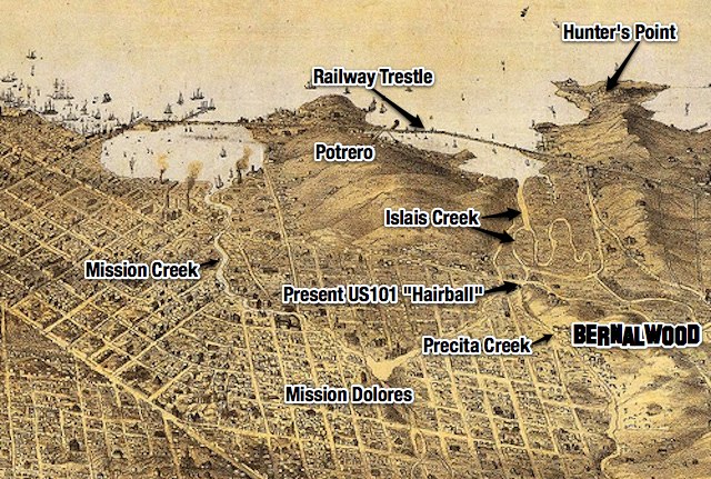
The perspective seems just right for Bernal Hill, but the key detail, I’d posit, is the elevated railroad trestle that stretches across the photo near the shoreline, roughly following the same route used by the present-day Caltrain. The area shown is present-day Bayview, but before it was filled in (in no small part with debris from the 1906 earthquake), the area was a vast, swampy marsh — which is why the railroad was built on an elevated trestle. Let’s zoom and enhance for more detail:

This panoramic illustration from 1868 shows the marshland of Islais Creek and the railway bridge that spanned it:
So that’s my guess. Do you see any other details that might help identify where this photo was taken?
UPDATE: Bernalwood contributor Joe Thomas (who lives in a house with an east-facing view) notes that there is a warehouse visible in the vintage photo:

From where Joe sits, it sure looks like that warehouse is still there, on Hudson at Toland!

Here’s the Google Streetview. Note the right-justified configuration of the doors:

PHOTO: Top, via Bernal Heights History Project

Looks like there a cantilever drawbridge there, too. Neat!
thank you bernalwood for all your posts. we are so lucky to have you.
Wednesday February 15, 1922.
I’m intrigued. February 15, 1922 was a Wednesday. Where’d you get that date?
Al Cormack of 6XG would come in and borrow records on Wednesday for his Friday night show.
The huge warehouse-looking building just right of center? I think it’s still there, at
RalstonHudson & Toland.Great one, Joe! Added to the main post above.
If you measure the ratio of length ti width of that building, you can calculate the relative bearing of the photographer. For example, in Joe’s photo, its length/width ratio is higher than in the original, so his photo is taken further to the right (i.e. Joe is standing to the the original photographer’s right hand side)
Here’s a photo taken from our house – the length to width ratio pretty well matches. So draw a straight line from their, through 307 Mullen, and you have your angle, or close to it. The angle of elevation looks about right too.
https://plus.google.com/113604104970209583178/posts/58gSWjjXe7V
Tom’s view looks really close. I believe that kind of northeast shoulder of the hill near the five-way intersection used to be called Peralta Heights.
Impressed!!!
yes – peralta heights also had some other little mound that was razed for fill and to make room for the new bayshore highway (101) so perhaps this photo was taken from there?
Here’s some more detail (and photos) of the Lost Peaks of Bernal Hill:
https://bernalwood.wordpress.com/2011/06/17/amazing-photo-from-1878-reveals-lost-peaks-of-bernal-hill/
The Southern Pacific RR started the Bayshore cutoff (that replaced the Bernal Cut route and is the current Caltrain route) in 1904 and finished in 1907.
Also, the “Long Bridge”, aka Railroad Ave, aka Kentucky, aka Third Ave (aka not the SPRR) was originally a trestle, but by the time this photo was taken, it had mainly been filled in. However, the SPRR cutoff definitely was a trestle as is clear even today.
I believe Islais Creek was still navigable at that point, so I’m guessing that cantilever bridge must have been on Third/Railroad Ave?
…so on that map, the bridge labeled “railroad trestle” is actually now Third St.
The warehouse (301 Toland St. at one end, 500 Selby St. at the other) was built in 1942, according to this handy site I found thanks to a tweet by @mizmay.
That’s quite a bit later than I would have thought…
Interesting. Frankly, not sure I don’t believe it tho. The match is too good, and the records are often wonky.
I’m not sure I believe the date either. The slant-roofed warehouse to its right doesn’t exist today, but there are several others just like it that do, a couple of blocks further southwest on Toland. The SF Property Information Map says they were constructed in 1940.
Do any of the ships in the bay look like WW II era Navy ships? I don’t really have an eye for that…
The warehouse did not exist in Harrison Ryker’s 1938 aerial photos. I’m sure it’s the same warehouse, but I think the photo must be post-1930s.