
Yesterday’s blog post about an 1888 photograph of the intersection of Mission and Army (Cesar Chavez Blvd.) generated a lot of great comments… including a very geeky digression about the apartment building at 3365 Chavez, right next door to the Principality of Chicken John.
You can see the building above; it’s set back from the street, with an unusual, angled facade. The oddness is even more obvious from above:
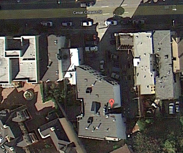
So…. Why??
Reader Jonathan seems to have solved the riddle. He writes:
Without doing more research, the diagonal building on Cesar Chavez you’re talking about (3365 Cesar Chavez) appears to have been moved onto the lot from across the street, presumably when Army Street was widened. If you take a look at the 1938 aerial, you’ll see an angled building on Capp across the street with two light wells in a nearly identical position, just reversed. Thus, when the building was moved, it was swung around 180 degrees so that the old south portion of the building (facing Army Street) became the new north portion. As large as that building is, they certainly moved larger.
To test this hypothesis, I merged a 1938 aerial photo with a 2012 Google Map image, and — by Jove! — the theory seems to check out!

Yes! Brilliant! So the mystery of the odd angle is solved. But why the deep setback from the street? Reader Jonathan again:
Why they placed it so deeply on the lot after moving it I can’t say, but a very logical guess is that they intended to build something else fronting on Cesar Chavez.
UPDATE: Reader Jonathan would like to revise this theory about the unusual setback at 3365 Cesar Chavez:
Now that I think more about it, they probably placed the building so deeply on the lot to allow for parking (rather than another building). Even in the 1940s parking was at a premium, and the building owner could have rented the spaces to tenants or others in the neighborhood.
Since the front of the building functions as a free-range parking lot to this very day, the latter theory certainly makes sense.

Crazy! I am duly impressed.
i bow down
> right next door to the Principality of Chicken John.
i love this!
TOU
Respect! Now, not only do we have a ghost of the railway easement, but a wandering ghost.
Now that I think more about it, they probably placed the building so deeply on the lot to allow for parking (rather than another building). Even in the 1940s parking was at a premium, and the building owner could have rented the spaces to tenants or others in the neighborhood.
I would wager they were also anticipating the routing of the Mission Freeway; if you look at the 1948 Trafficways plans, the basic idea was to have a trench running out along Capp/SVN from the Central Freeway to 26th or so. It would then follow Coleridge past Bernal Heights, then to the San Jose Avenue cut (per Eric Fischer’s compilation on Flickr). It looks like this building owner was very attached to his property to go to this much trouble, or maybe he figured that having an on-ramp next to his property would enhance the value.
That is some damn fine sleuthing.
I just moved to Precitaville and walked by this building for the first time less than 24 hrs ago, and already my curiosity has been satisfied. I love the random angle, it feels like an artifact from an ancient European city (“the old Roman road ran along this path…”). Thanks Jonathan and Bernalwood!
WOW! GREAT sleuthing! So Army must’ve gotten widened northward only: buildings on south side are in same locations 1938 and current; but on the north side you can see the narrowing of the triangle, AND you can also see clearly that the building on the north side two lots east of the original 3365 Cesar Chavez site was moved back and its shed removed so it could nestle into its back neighbor on Capp–ditto for the building two lots east of that one too…
Could it be that the trapezoidal building on the corner is now clooney’s pub on valencia? i’m not a scientician but it looks like it to me.
OK I’m totally wrong that building is still there and it’s the palace steak house. do smarter people than me know what the deal it with the clooney’s building??
The shape of the building may have something to do with an old property line — I would have to do some more research. BUT, the intersection of Valencia and 25th is an interesting place as it is one of several areas where you can still trace the route of the old San Francisco – San Jose (later the Southern Pacific) Railroad which ran through the Mission District. If you look at an aerial view of the area, the trace of the old railroad line is fairly obvious running southwest to northeast at a diagonal. That said, I am fairly positive that the shape of the building where Clooney’s Pub is located was NOT built a response to the railroad. However, the building just across to the street to the north clearly WAS built in response to the railroad line. Lots more examples out there if you know where to look.
Dude, you are on to something. I always assumed Clooney’s shape had something to do with the railroad right of way — the Valencia St station was across the street — but that’s *not* the building that was there in 1950, never mind 1938.
Here’s an explanatory GIF — more on this tomorrow.
And you can see the pre-Clooney’s building in this view of the old Valencia St Station intersection in the SFPL archive. I believe this looks east on 25th across Valencia, so the proto-clooney’s is behind the station, across Valencia on on the right.
Actually, from building placement/spacing/orientation, I think the view in the 1937 photo is on 25th facing west, so all you see of proto-Clooneys/1401 Valencia is a (second-floor) eave on the far left. In the first 1906 photo in your blogpost (http://burritojustice.com/2011/06/27/1905-sf-sanborn-maps-now-in-color/), facing east, I think you can actually spy the signage on 1401 Valencia (starting “RE…”) just to the right of that little shed on the right of the tracks. Cd it be a composite building? Tax records say 1401 Valencia was built in 1925, and if you compare current and 1938 aerial, you see the same footprint of the one-story section in back and the two-story section abutting the neighboring building; maybe a two story structure was placed or built atop…
The SFPL photo is looking west toward San Jose. I happen to recognize the view because the building at far left in the distance is still standing on the corner of San Jose and Juri. Still don’t know about Clooney’s though. Another good candidate for a moved building.
Whoops, thanks, west indeed. (This is what happens when I can’t see Sutro, I get all confused. And man do I need to geo-index my own posts.)
The 1906 Sanborn shows a corner saloon, and the 1906 Crocker-Langley directory lists 1401 Valencia as “liquors” belonging to Jeremiah O’Reilly (who lived at 1311 Guerrero).
Maybe the “RE” is O’Reilly’s wrapped around the corner? I can barely wrap my head around moving a building! Sliding it on top of another‽ Oh man.
And it looks like the apartments were added on top, in 1924 — just found a most excellent Clooney’s history written only last month. Doesn’t have the details on the addition (yet), but a pretty epic read nonetheless.
My “aha!:” there is an “O” (no apostrophe) before the “RE” for “O’Reilly’s” in the 1906 photo; I’d mistook it for something architectural…
hi hi hi hi, omg. This is amazing. Ok, I wrote the “epic” post you referred to; I live above Clooney’s and yes, think about the shape a lot. I am also a railfan and about died when I moved here and realized what I had moved on top of, but all of this seriously makes me want to explode with glee. As for the addition of the apartments, I dont’ have answers, but I have some theories (as promised), but this is making me rethink some of my theories. I have to go read your post and all of these others. Will be back. We should all have a beer together at Pi and figure this portion of the hood out; who is in?
So cool.
I think the set back was for parking b/c the whole move was made during a time of loving cars, hence the street widening, etc.–ample parking in new building’s lot and set back away from traffic–Brilliant–not much has changed since the current configuration.
BRAVO!
Pingback: A Brief GIF History of Army Street (and Clooney’s) « Burrito Justice
More on our rotating friend on Army (as well as some history of Clooney’s).
The owner of the building, Edwin Nocum is a super cool guy. It’s been in his family for generations. The reason why the building is set back is because Army street becomes a fucking river from time to time. My living room couch was floating one morning. Garages flood, car are swept away. It’s happened twice in the 16 years I’ve been here. I saved an old lady one morning. The 2 times it’s happened it lasted like an hour or so. It’s crazy. The south side of Army is like 3 feet deep. My guess is the rain overwhelms the sewer system and backs up, then everything comes out of the sewer and then it’s all about gravity. We just had that main replaced, so who knows if the new system will do the same thing. An old lady told me it used to happen more often, when she was a little girl.
And just so we are talking about stuff, you guys probably don’t know this, but my building was built right after the earthquake of ’06. Built by the San Francisco Post Card Company, and used as a manufacturing plant for silkscreening postcards until they folded in 1957. Then, it was a mini-storage until I got it in ’97.
The tenant before me paid $200 a month rent. The taxes were $300 a year. It was appraised in 1988 for $60,000.
life goes on…
chicken
Actually, I do remember a time a few years ago when the flood rapids on Army were kayakable.
dang… yes the new sewer will definitely make the amount of water on the street less. Now I wished we had kayaked it before we fixed it. We have some good animation of it… before and after.
houses on the south side (where the old creek was) which are below the level of the sidewalk will still have problems but at least the couches wont float away
Excellent sleuthing! I love these kinds of urban discoveries.
Pingback: Three Long-Lost Views of Army Street at Midcentury | Bernalwood
Pingback: Tonight: Learn About Buildings That Have Moved, with the Bernal Heights History Project | Bernalwood