Then and Now: Folsom at Precita, 1943

New Track Work and Repairs L.V. Newton Negative 6

When they are not giving you expensive parking tickets or botching your commute, our friends at the San Francisco Municipal  Transportation Agency (SFMTA) also maintain a historical photo archive that’s accessible via a spiffy photo website for blissful procrastination focused browsing by members of the general public.

That’s where Bernalwood found this retrolicious photo of Folsom Street at Precita in 1943, looking north from the western end of Precita Park.

Here’s how it looks now, 71 years later, on May 3, 2014:

folsomprecita2014

So many details to appreciate in that older view! Behold, the annotated version:

folsomprecita1943f

As you can see, the Palermo Bakery is now home to Precita Clean laundromat, while the Yosemite Meat Market on the corner is the location of today’s Charlie’s Cafe.

Providentially, Bernalwood previously shared a view of the same building from the opposite direction, as captured from the intersection of Folsom and Army (Cesar Chavez) looking south just one year earlier, in 1942:

ArmyFolsom1942

And when we zoom and enhance that photo, we get a terrific view of the Yosemite Meat Market sign that was hiding just around the corner in the 1943 perspective:

ArmyFolsom1942.Yosemite

Fun!

If you’ve enjoyed this trip down the rabbit hole historical interlude, you’ll also enjoy this recent post from La Lengua rebel leader Burrito Justice, who explored the intersection of Mission Street at 29th using photos from the same SFMTA archive.

Here’s a teaser, showing the site of today’s Pizzahacker:

29th Street and Mission Street, Claims Department Case 5800

And of course, there’s no substitute for going to the original source. So if you don’t mind kissing your productivity goodbye, you can also explore the SFMTA photo archive yourself. It’s fun, it’s mega-informative, and it may even help you feel good about paying off your next parking ticket, since you’ll know that at least some part of that money will be put to good use.

PHOTOS: 1943 photos by SFMTA. 2014 photo by Telstar Logistic. 1942 photo via San Francisco Public Library

Former Neighbor, Now Living in NYC, Remembers Us Fondly

pianist

Until late last year, Hilary Pollack lived in Bernal’s La Lengua Autonomous Zone. Then she moved to New York.

Now, as an esteemed member of the Bernal Heights Alumni Network, San Francisco remains on her mind, and she recently shared some memories on her blog:

I moved to New York on September 1st, 2013. I often get asked, by people both here and in California, whether or not I like it. And I feel like I should be completely sure how to answer them, but I’m not.

My coworkers, my parents, or my friends back in California (many of whom I still text or Gchat with on a near-daily basis, one of the few plus-sides of contemporary tech-communication norms) usually pose this question as well-meaning small talk, but I’ve yet to come up with a confident answer. I feel 100-percent sure that I needed to move here at some point my life, and 110-percent sure that I chose the perfect time to do it. But whether I think that New York is patently better to live in than San Francisco or any other decent metropolis? Well, I’m just not sure about that, no matter how many people tell me that the colloquial Big Apple is the best city in the world. There’s so much to it, I know, but it lacks trees (especially of the palm variety), decently priced avocados, and underdog charm (something that’s rapidly and violently being sucked out of my beloved San Francisco).

The house that I left behind was at the base of Bernal Hill. I would take 6-minute hikes from my front door to its peak, where I could ogle all of the Australian Shepherds in the city as they chased each other in circles around its slopes. Once, some local do-gooder mischief-makers dragged a stand-up piano up to the top of it, and people would play concertos and shit while others would sit in circles around them like hungry first-graders. Another time, someone made an expansive crop circle at its base out of red rocks. It was magical.

That’s just a taste; to finish the thought, read the whole thing.

PHOTO: via Hilary Pollack

Violent Tales from Pre-Gentrification Bernal Heights During the Eighties

BernalMap1884.crime

Bernal Heights was a tough place during the Eighties. It was a time of rampant lawlessness, violent crime, substance abuse, and lots of un-neighborly behavior.

Burrito Justice, chief spokesblogger for the La Lenguan separatists, recently posted a series of tales that vividly captures the sordid underbelly of life in Bernal Heights during the dark days of the 1880s. Thus we meet Proto-Neighbor Jeremiah Buckley, who appears to have had some issues:

1888-daily-alta-bernal-moonshine

MEMO TO HOLY WATER: Put “Goat Chasers Great Internal Tonic and Stomach Reviver” on the cocktail menu, please, and make ours a double.

In any event, after concluding that “Twenty-seventh and Alabama” likely refers to the corner of today’s Precita and Alabama, Burrito Justice cites this sordid chapter of Bernal Heights history as justification for the cause of La Lenguan independence. “All La Lenguan residents should consider this fair warning when traversing Precitaville, as Consular services may not be available,” he writes.

Yet this strains credibility. After all, as he himself has documented, one of the most infamous hives of crime and scandal in the Dominion of Bernalwood was the Cable House, which once stood at the corner of Tiffany and Duncan, smack in the middle of the La Lenguan heartland.

The “Railroad Hotel” [was] a 30 room boarding house. Built in the 1880s, it was once known as the “Cable House”, and was torn down in the 1920s… All sorts of crazy-ass things happened at 24 Tiffany. Seriously, they could have made a reality TV show about it. If you ever time travel and stay at the Railroad Hotel, it’s best to not leave your things out:

1904-24-tiffany

Likewise, at La Lengua’s Cable House, it was best to avoid the liquor:

1899-24-tiffany-hugh-lynch-fall-out-window

IMAGES: 1884 Bernal Heights from the David Rumsey Historical Collection. Press clippings via Burrito Justice.

UPDATED – Remember When: The Day DiFi Laughed Her Way Down the Esmeralda Slides

difionslide

Once upon a time, several years before she became a United States Senator with a thing for national security issues, then-Mayor Diane Feinstein came to Bernal Heights on a warm winter day in 1979.

She was here to celebrate the dedication of the Esmeralda Mini-Park on the west side of Bernal Hill, and to test drive the extended-length children’s slides that had just been installed after an intense community-organizing effort.

Neighbor Barbara Bagot, who kindly shared this image, remembers:

I found the Bernal Journal slide photo on Mike Nolan’s Facebook page.  (I think that’s my brother Bucky, top left.)  Difi came prepared–wearing slacks instead of her typical skirt.

Since that groovy moment in time bears so little resemblance to the DiFi we know today, let’s zoom and enhance for a closer look:

difionslide.detailBSC

PS: In the story below the photo of DiFi, notice also that even back then, people were wondering what was up with the wacky, wonderful Beatles House on Precita.

UPDATE: Neighbor Michael Nolan just shared the flier printed to announce the dedication of the Esmeralda slides. So cuuuuuute! So pre-desktop publishing!

Esmeralda Mini-Parkflier020379

What You Missed When You Missed Glenn Lym’s Talk About the Lost Geology of Bernal Heights

Glenn Lym addressed a full house at the Bernal Heights branch of the San Francisco Public Library on Wednesday night. His presentation focused on how San Francisco transformed the hilly native landscape into flat land suitable for development.

Much of the first half hour recapped Glenn’s HERE5 documentary, which was brilliant. But having first seen that the day before, a second pass helped me understand the process better. Here’s the story:

In 1849, very little of San Francisco was flat. Sand dunes over 100 feet high made land passage impractical between “downtown” and the Mission. Millions of cubic yards of material was moved to create the flat center of San Francisco we see today.

One remarkable photo in the slideshow showed picnickers on a peak of Potrero Hill that Glenn said no longer exists; a spot that is now either Franklin Square or the Safeway shopping center (previously the site of Seals Stadium). I think this may have been called Irish Hill, but I’m not sure. (John Blackburn corrects me in the comments; Irish Hill was on the East side of Potrero.)

In the second half, Glenn showed Coast Survey-based CAD reconstructions of the lost peaks of Bernal Heights, though he wasn’t sure when they had been removed.

Harrison Ryker’s 1938 photos showed a peak at the top of Ripley Street, above the intersection with Peralta, which was missing on a later photo:

An older gentleman in the back, attested by others to have lived on Ripley, said the hilltop removal began in 1939, stopped during the war, and resumed afterwards — leaving the block between Peralta, Esmeralda, Franconia and Samoset flat by around 1950. The debris was probably used to fill Isais Creek, with some of it possibly used as ship ballast.

The fourth peak, where the Franconia/Brewster public gardens are today, south of Rutledge, was removed prior to 1938. Some industry, possibly hilltop-removal, was visible in an aerial photo that showed the Maxwell advertisement atop Bernal Hill, which suggests it happened in the mid 1920s.

Glenn referred to historical posts by Burrito Justice and Bernalwood several times in his presentation, with special attention paid to Burrito Justice’s posts on the Valencia Hotel collapse and Serpentinia, and Bernalwood’s epic post on the history of Army Street/Cesar Chavez’s awfulness.

Bernal’s superior seismic safety was discussed in the Q&A after the talk, though I don’t think our chert was specifically credited.

This Proposed Freeway Tunnel Under Bernal Heights Would Have Destroyed My Home

BernalTunnel.1941

Courtesy of Eric Fischer, king of the map geeks, your Bernalwood editor was alerted yesterday about a 1941 map detailing a freeway proposal that would have required the construction of a 2945 foot-long automobile tunnel under Bernal Hill.

Unlike other unrealized plans to tunnel through our neighborhood, this scheme would have created a tunnel running underneath the most central parts of Bernal Heights, via Andover starting at Cortland on the south side, and exiting beneath Shotwell on the north:

BernalTunnel.1941.detail

On the bright side, the exaggerated side-cut elevation of Bernal Hill is rather cool:

BernalTunnel.elevation

There’s a lot of obvious things for everyone to dislike about this idea. Yes, of course, cutting the neighborhood in half and clogging it with smog-belching automobile traffic would have been terrible and all… but the real issue for me is that the northern portal of the Bernal Heights Tunnel would have been located on the exact location of my Precita Avenue home:

BernalTunnel.me

Indeed, it appears that the very spot where I write this sentence right now would have been appropriated to make way for a four-lane concrete slab carrying traffic in and out of the northern tunnel opening.

All in the name of progress, naturally.

What this means, of course, is that in some sort of alternate science fiction timeline, the tunnel project was approved and completed, resulting in the condemnation and demolition of my home. Which means I never ended up in Bernal Heights, and Bernalwood never existed, and we would not be enjoying this lovely day together.

Of course, in an alternate-alternate science fiction timeline, it’s also possible that I used a chronological wormhole to return to 1941 as a time-traveling NIMBY to prevent the construction of the Bernal Heights Tunnel from happening in the first place. It’d be kind of like Arnold Schwarzenegger in Terminator, only I’d be armed with vast wads of inflation-appreciated cash and an intimate understanding of bureaucratic minutiae. (As an added bonus, I’d probably also warn them about Pearl Harbor.)

Or perhaps that’s not science fiction at all. Perhaps the only reason we are enjoying this lovely day together at all is because some Future NIMBY actually did travel back in time to prevent the tunnel from ever being built!

The mind reels…

PHOTOS: via the ever-fabulous Eric Fisher

Canine Rescue: Help Restore the Doggie Diner Heads

bernal.doggiehead

doggiediner.1981

As you may recall, Bernalwood recently explored the history of the Bernal Heights branch of the Doggie Diner restaurant chain that ruled the corner of Mission and Cesar Chavez from the 1960s until the 1980s.

You may also recall that three giant Doggie Diner fiberglass mascots survive to this day as a traveling trio of cultural ambassadors mounted to the back of an old trailer:

Doggie Diner heads invade the Mission District

And you may even remember that many Citizens of Bernalwood were overjoyed by these same doggie heads last October, when they were spotted on Folsom Street wearing sporty knit wool cozies:

yarndogs1

Well, the doggies are now 50 years old, which is why the esteemed John Law,  custodian of the Doggie Diner heads, has launched a worthy Kickstarter campaign to fund their restoration:

I and a small handful of friends have been bringing these local icons to charity events, parades, and art happenings for the last 20 years FOR FREE and for the sheer joy of it. These local icons are the only things that seem to brighten the day of everyone who sees them—every time—and for me, that is worth all the labor and expenses that I have poured into them years.

Twenty years of hauling them around on a rickety trailer and 50 years in the sun has taken its toll, and they are in desperate need of repair. But restoring a vintage, 10-foot-tall, 300lb fiberglass and metal sculpture is complicated, labor intensive, and expensive—and we have three of them! We need to raise $48K in just 30 days to get the work done.

Though these Doggie Diner heads do not live in Bernal, history has made them a part of us. And as further evidence of this project’s bona fides, Billy Collister, one of the metalworkers participating in the restoration effort, was the contractor who completed my home renovation years ago, so your Bernalwood editor is quite comfortable endorsing both his workmanship and industry.

Most importantly, amid constant socio-economic change and the multi-generational transformation of our neighborhood’s landscape, seldom do we have the chance to preserve a such a tangible slice of an older, even weirder San Francisco.

Especially one that’s so easy to park.

This is one such opportunity. You can donate to the Doggie Diner Restoration effort right here.

PHOTOS: Top, Historic photos of Bernal’s Doggie Diner at the corner of Mission and Cesar Chavez.

Is There a Frenchman Buried Under Precita Park?

illofrenchman

Neighbor Vicky from the Bernal Heights History Project calls our attention to an August 12, 1897 article in the San Francisco Call newspaper about a tragic accident that took place while installing a sewer line near Precita Park:

sewerhedThe article goes on to say

The caving in of the southern embankment of a new sewer being put in on Precita Avenue, from Alabama street to Army, was the scane of an unfortunate occurrence yesterday afternoon. In the construction of this sewer a man lost his life by being crushed to death beneath tons of rock and earth, which fell in on top of him while at work in the bottom at a depth of twelve feet.

The name of the unfortunate man could not be ascertained. He was simply known as “Frenchy,” probably because he belonged to that nationality. All that was known of him by the other workmen and the people about Precita Valley was that he took a section of the sewer from George M. Ferine, who was tbe contractor to whom the contract was let’ by the Supervisors. Perine. in turn, gave out sections of the work to any person who applied for a share. “Frenchy” secured fifty feet of contract on the topmost point of the line, where it was found necessary to sink to a depth of twelve feet in order to bring the bottom level to the line.

The unfortunate man had worked hard and faithfully on his job from the time he got the contract until yesterday, when he hopefully announced to some of bis fel-low-workmen that he had just two more feet to dig when his portion of the contract would jbe finished. This was about twenty minutes before the life was crushed out ot his body by the falling earth.

As was the custom of the time, the article goes on to describe the precise circumstances of Frenchy’s demise in gruesome detail. The body was recovered, apparently, but the article provides no additional detail about burial arrangements.

So was Frenchy laid to rest near the site of the accident that claimed his life? Let the legend begin…

Neighbor Explains 45 Years of Bernal Heights History in 56 Seconds

neighborralph

Neighbor Ralph lives a few doors down from me in Precitaville, and he’s been here for a long time. His father bought the house he lives in now back in 1943 with money he made working as a laborer at Fort Mason. 

Ralph remembers the years after World War II, when San Francisco’s population swelled with returning soldiers and sailors who decided to stay. Everyone had work, he recalled, particularly at the shipyards.”Hunter’s Point was going 24 hours a day,” he says.

Ralph worked for the SFPD as a policeman. He started on the beat, but then spent most of his career “inside” at the Hall of Justice before retiring.

He pointed to my house. “Sam lived there,” he said. That jogged my memory about the census records from 1940. Sam? Sam Piazza? “Yeah, Sam Piazza.” Ralph knew him.

In Ralph’s earliest memories, Bernal Heights was Italian and Irish. Then he remembers Mexicans and Filipinos moving in, and now Ralph notices that the neighborhood is changing again.

This is Neighbor Ralph’s thumbnail history of the last 45 years of Bernal Heights history:

PHOTO: Neighbor Ralph by Telstar Logistics

Then and Now: The View from a Horse Pasture on Mission Near Precita

mctiguepasture1

Bernalwood has received another photo shared from the family albums of Greg Dabel, the great, great grandson of Joseph McTigue, who owned a saddlery business that occupied the site that is now home to El Rio during the first decades of the 20th century.

In this installment, Mr. Dabel writes:

I scanned a couple of photos from the family album taken in 1923. My best guess is that these were taken standing in the open fields on the west side of Mission (between Army and Valencia).

Indeed! The photo above shows the view from one of the McTigue pastures. It was taken on the western side of Mission, looking east while standing on the site of the building that is now the former Sears department store.

And how do we know this? We know this because the two buildings in the background on the right side of the photo are still there! Check it:

Missionprecita2013

Here’s a bonus photo, also taken from the McTigue pasture. Bernalwood believes it shows the view looking north, with an apartment building that used to stand at the intersection of Mission and Army (Cesar Chavez) visible in the background:

mctiguepasture2

HISTORICAL PHOTOS: Courtesy of Greg Dabel

A History of the Former McTigue Harness Shop on Mission Street, as Shared by His Great-Great Grandson

McTigue Livery copyBSC

1901.McTigueInterior

During the late 19th and early 20th centuries, the McTigue family operated a harness manufacturing shop and livery stable for horses on Mission Street at the intersection of Precita, roughly on the site where El Rio stands today. We wrote about all this recently while dissecting an aerial photo of Bernal Heights taken during the 1920s.

Here’s what Mission Street at Precita looked like in May, 1923. Notice that there are several carriages parked in front of the McTigue Livery on the left:

missionprecita1923

When we zoom and enhance the image, we clearly see the McTigue name on the front of the livery stable building:

1923mcTigue

Here’s the same spot, in August, 1927, at which point McTigue Livery had been replaced by Mission Chevrolet (which is today home to O’Reilly Auto Parts):

MissionPrecita1927

La Lengua propagandist Burrito Justice located this entry from the 1908 City Directory:

screen-shot-2009-10-21-at-9-33-31-am

This tells us that the McTigues also operated a harness making shop (at 3156 Mission), just south of the livery stable,  on the very site where El Rio now makes the universe a happier place.

About a year ago, Bernal Neighbor Michael Nolan did a geek-out on the McTigues in a Bernalwood comment, and discovered the following:

Did some genealogical research on the McTigue family, the harness makers. Michael McTigue and Frances Acton were Irish immigrants born in 1830 and 1832 who started the business South of Market . In 1872, they were living at 273 Minna, In 1880 on 8 1/2 Moss. with children Augusta, Fanny, Joseph, Richard, John and Jennie. By 1896 they were living at 19 Alvarado with their harness factory at 3156 Mission Street. Joseph W. McTigue was born in 1866 and died in 1939. He married Mary Theresa Costello and they had a daughter, Marie. She married William Dabel and in the 1940 census they lived at 3182A Mission Street. They had a son William (1927-2006) and I”m trying to trace his descendants.

Neighbor Michael was spot-on, because last week Bernalwood received a note from one of those descendants: Greg Dabel, the great-great grandson of Joseph W. McTigue(!!!!), who had stumbled upon our story about the aerial photo from 1924. Mr. Dabel told us:

My great great grandfather had various locations along the 3000-3100 block of Mission Street for buildings, stables, holding corrals, etc. Known addresses were: 3088-98; 3156; 3180 Mission and 1665 Valencia.

Mr. Dabel also shared a family history of Joseph McTigue, along with several never-before-seen photos of his equine businesses on Mission Street.

This was Joseph W. McTigue:

Joe McTigue

And this was his story…

The Dabel Family
CHAPTER 15

Joseph William McTIGUE
1865-1939
Your great, great grandfather on your father’s side

Joseph McTigue was the first son of Michael and Fanny (Acton) McTigue. The family lived in an apartment on Kearney Street in San Francisco, California. Joseph grew up helping his father in the livery business located in downtown San Francisco.

According to the family, when Joseph McTigue was about twenty years old he left San Francisco to work as a stagecoach driver in the Sierra Nevada Mountains. He was employed by the Yosemite Stage and Turnpike Company and drove the Mariposa-to-Yosemite Valley stage run. The company had daily passenger stage run.

When Joseph McTigue returned San Francisco he married Mary Theresa Costello at San Francisco’s St. John’s Catholic Church and he opened a new livery business in San Francisco’s Mission District. It is not clear whether he joined his father in moving the existing livery business from the downtown location or he started a new location. From photos of the business we know that his brother Richard ‘Dick’ McTigue was also part of the family business. In 1903 the San Francisco telephone book listed ‘Joseph W. McTigue – Saddle and Harness Maker – 3156 Mission Street. Phone number: ‘Church 2833.’

1901.McTigueworkshop

Joseph McTigue’s livery business thrived. He rented horses, wagons, and buggies. The local butcher and baker rented his wagons and horses to deliver their goods around the City. Others needing transport would rent a horse and buggy for the day.

Mission Street-1

‘Joe’ McTigue also had time and money to support racing horses. The family specialized in ‘harness-racing.’ Their prized trotter race horse named ‘Darby Mac’ won many weekend races held at Golden Gate Park and other Bay Area race tracks.

Joe.DickMcTigue3160 Mission

Family oral history says that Joseph McTigue missed a lucrative business opportunity. As the story goes, in about 1898 he was approached by a salesman, perhaps the owner himself, of the newly-founded Goodyear Tire and Rubber Company. The company made rubber horseshoe pads so it was natural for the salesman to call on the McTigue Brothers. In addition to horseshoe pads and tires for bicycles, Goodyear was also making tires for ‘horseless carriages’ (automobiles).

The McTigue brothers had a well-established business and a perfect location to sell these rubber tires. It is said Goodyear offered Joseph McTigue an exclusive San Francisco franchise rights to sell tires and rubber products. But Joseph McTigue, a ‘hostler’ through-and-through, turned down the opportunity. He was not keen on the ‘new-fangled’ automobile and refused to believe that autos would ever replace horses.

Eventually it was the automobile that brought an end to the McTigue livery business. The McTigue Harness and Saddler Shop closed its doors in 1940. Most horse collars and other equipment in stock were sold. What was not sold was stored in the basement or loaded into the remaining wagons and towed to a Bay landfill near Hunter’s Point, San Francisco. Joseph McTigue died in 1939. His Death Certificate listed his profession as ‘Harness-Maker for 50 years.’

Many thanks to Greg Dabel for so generously sharing his family history!

PHOTOS: McTigue family, courtesy of Greg Dabel

Massive New Waterfront Mural Visible from Bernal Heights

silomural1

silomiural2

Bernal Heights is an interesting place to spend time, in no small part because the neighborhood rewards sustained attention in both micro and macro modes. That is, there’s a lot to notice both when you zoom in on street-level details here, or when you go big to take in the panoramic vistas.

Case in point: There’s a new mural emerging on the horizon to the east of Bernal Hill. It’s taking shape on the side of that giant, derelict grain silo near the bay, and as you can see above, Bernalwood contributor Joe Thomas has been tracking its progress from his high-altitude observation post on Bernal’s east slope.

Big mural! But how? And why?

The silos themselves were built in 1918, but they’ve been dormant since the 1989 earthquake. The Port of San Francisco offers this rendering of how the finished mural will look:

muralrender1

The Port also provides a terrific project description:

Bayview Rise, an illuminated mural for Port Pier 92, weaves together iconic imagery reflecting the Bayview neighborhood’s changing economy, ecology, and community. Its large-scale graphics will make its primary images visible from a distance, while views up close will reveal the abstract patterns from which those images are composed. The artwork is conceived as a gateway into Bayview Hunters Point and will be visible and changing from day to night.

The mural is designed by artists Laura Hadadd and Tom Drugan. The mural’s graphic imagery is rooted in the Bayview’s historic and future conditions, but with an emphasis on elements that float, fly, and rise. The composition creates a spatial illusion in which elements appear to rise up and out from a horizon where water meets land and sky.

Grounding the image is a bottom layer of water, representing both the San Francisco Bay and the past marshlands of Islais Creek. Submerged in the water, as a symbol of the neighborhood’s past, is a reference to historic Butchertown. The primary icon rising from the horizon line is a soaring heron, which ties to nearby Heron’s Head Park, a successful environmental restoration by the Port. Other imagery represented in the artwork include native cherry plants, shorebirds, and a reference to a quote by community activist Essie Webb who likened Hunters Point to a balloon waiting to be re-inflated. Because so many individual Bayview heroes came to light in the research process, it was impossible to represent just a few and seemed more appropriate to honor all of them with a concept they might all believe in, that of “rise.” The images within the mural have been combined, overlapped, and juxtaposed in a triangular matrix so there appear to be metamorphoses between cherries and balloons, water and birds, land and leaves.

At night colored lights will cycle through the colors red, green, and blue, on both the façade and the adjacent silos. Every night the lighting schedule will vary, so that the art is dynamic and always changing its appearance. The lights will cause the mural imagery to change its appearance with changing light colors. An individual light color will cause parts of the mural of that same color to be highlighted while other colors recede into the dark background. As the light colors shift, images will appear to float in and out of the scene. This striking effect will result in the appearance of an animated graphic abstractly representing a neighborhood in transformation, Bayview Rising.

Impressive!  Oh, and that bit about using illumination to highlight or hide various colors in the mural at night? Here’s how that’s going to look:

nightmural

Badass! Happily, Bernal will enjoy a superb view.

PHOTOS: Top, Joe Thomas. Below, Port of San Francisco. Special thanks to Norman Weinfield for the tip. 

Unbuilt Bernal Heights: Our Future That Never Was

Burnhambernalwood-1905

The only thing Bernalwood loves more than a good local history lesson is a strong dose of local fantasy science-fiction. Luckily for us, some recent synchronicity has conspired to provide a tasty mixture of the two.  Here’s how it unfolds…

Part One: A few weeks ago, I took Bernalwood’s Cub Reporter to visit the new Exploratorium. While we were there, we wandered down a long hallway and into the Bay Observatory Gallery at the northeast corner of the museum. And in the Bay Observatory Gallery, we found a very cool collection of maps:

exploratorimmaps

As you can see, the Cub Reporter was fascinated with a map visualization created by the amazing Eric Fischer (which quite speaks well of her).

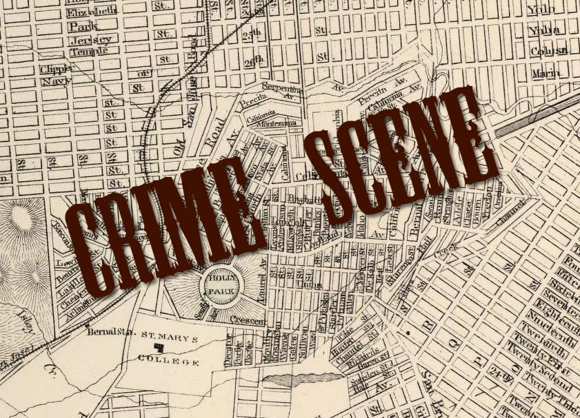
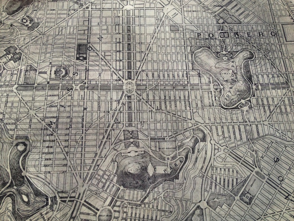
Simultaneously, your Bernalwood editor was intrigued by a map of an ambitious redevelopment plan that envisioned San Francisco as a kind of Paris by the Bay, with grand boulevards and ornate gardens slicing through our familiar street grid. Naturally, I took a particular interest in the Bernal Heights portion of the map:

BernalBurnham1905.A

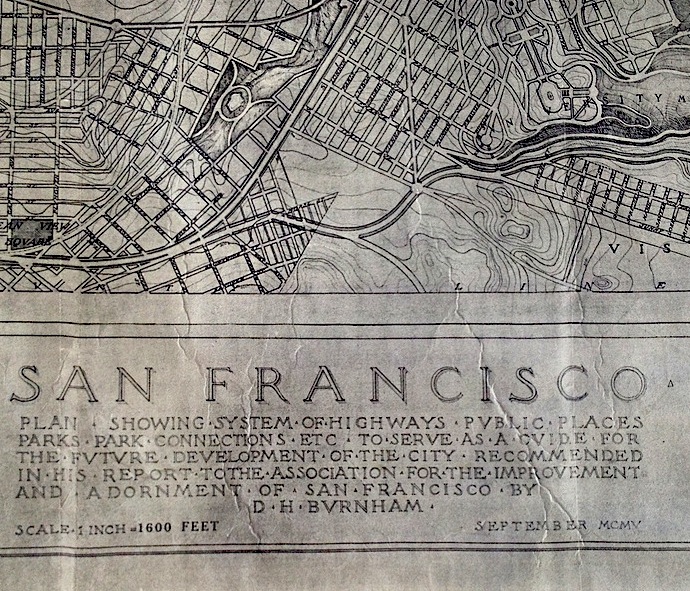
So much to absorb! To facilitate later study, I snapped a few quick photos, including one of the map legend:

1905MapDetailThe legend identified the map as:

Plan, showing system of highways, public places, parks, park connections, etc., to serve as a guide for the future development of the city, recommended in his report to the Association for theImprovement and Adornment of San Francisco, by D.H. Burnham – September 1905

Hmmmmmmmm. We’ll explore all the details of the map in a moment, but first, let’s consider that curious synchronicity, which arrived in the form of…

Part Two:  Have you heard of 99% Invisible? It’s a contemporary and wonderful radio documentary series created by producer Roman Mars here in San Francisco as a project of public radio KALW and the American Institute of Architects.

99% Invisible is a show “about design, architecture, and the 99% invisible activity that shapes our world,” with an emphasis on that 99% part — which is to say that 99% Invisible is about the history, personalities, and contextual quirks from which meaningful design and architecture emerges. This sounds heady and theoretical, but the show is anything but; it’s quirky and vibrant with an emphasis on people and great storytelling. Listen to it — it will make you see the world with shiny new eyes.

As fate (and synchronicity) would have it, the most recent episode of 99% Invisible is called “Unbuilt,” and it happens to be about unrealized urban master plans in general — and Daniel Burnham’s 1905 master plan for San Francisco in particular. So while listening to 99% Invisible this week, I finally got the backstory about Daniel Burnham’s vision for the future of San Francisco:

Daniel Burnham was the mastermind behind the White City at the 1893 Columbian Exposition in Chicago It was the pinnacle of “The City Beautiful” movement, with big civic centers and grand neo-classical structures to stir the soul.

Burnham was hired by big-time downtown business owners of San Francisco to turn this raggedy (if well-off) city into something majestic. Danial Burnham’s team shows up and they set up shop in a cottage on the summit of Twin Peaks so they can survey the city and craft the perfect plan…which was completed in the fall of 1905.

And the legend goes, all the books were delivered to city hall for distribution on April 17, 1906–the day before the great earthquake pulverized San Francisco.

Burnham’s grand master plan was derailed by the 1906 earthquake. The devastation of the quake might have seemed like a perfect opportunity to implement the more disruptive aspects of his urban design, but the reality was that traumatized San Franciscans simply wanted to rebuild quickly and in a manner that felt familiar. So they did.

Burnham’s San Francisco plan went unbuilt.

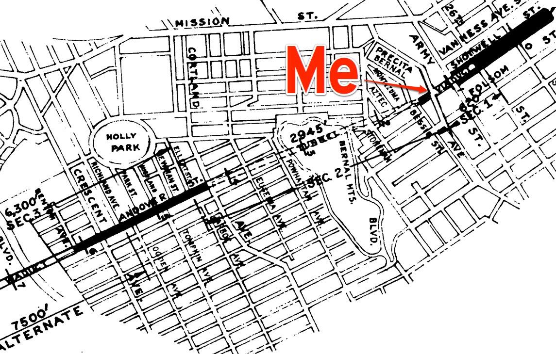
But what had he envisioned for the future of Bernal Heights? Let’s zoom and enhance the map I found at the Exploratorium:

burnhambernal2Burnham saw Bernal Hill as the grand southern terminus of two criss-crossing promenades, which presumably would have looked somewhat like The Mall in Washington DC.

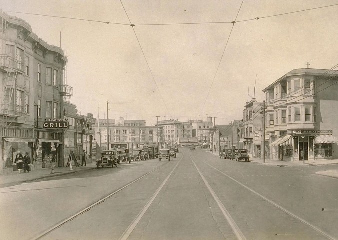
The “Mission Parkway” promenade would have run east to west along an axis between 23rd and 24th Streets. Meanwhile, the north-south “Mission Arcade” promenade would supplant today’s South Van Ness Avenue, with a grand interchange crossing the Mission Parkway around 24th and South Van Ness.

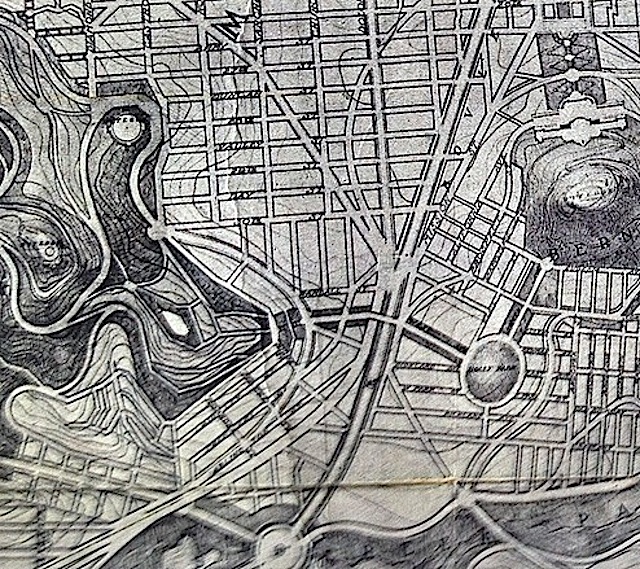
Looking even more closely…

burnham.bernaldetail

Precita Park survives in slightly modified form, but Burnham proposed creating a wide garden on the north face of Bernal Hill, roughly along the axis of contemporary Shotwell Street, running continuously from Army (Cesar Chavez) to Stoneman Street.

Burnham also wanted to erect a large, neo-classical building on Bernal Hill to overlook the Mission. He did not indicate what this monumental building would be used for, but we can safely assume it would have been Something Very Important, like a world-renowned collection of Dried Macaroni Arts and Crafts or the urban palace of Lord Mark Zuckerberg, the Duke of Facebook.

A set of smaller monument-style buildings would stand on the northeastern side of Bernal Hill, overlooking a huge playground, while the summit of the hill would feature several small gardens (with grand fountains, perhaps?) for leisurely recreation.

On the south side of Bernal, Burnham envisioned a continuous promenade linking Holly Park to the soutwest side of Bernal Hill, while a similar promenade would link Holly Park to Mission Street before continuing on to an expanded Glen Park open space:

burnhamhollypk

Personally, what I like best about Burnham’s plan for Bernal Heights is how easy it is to visualize. For example, it’s not difficult to imagine the view looking south from 24th and South Van Ness, with that long carpet of green grass rolling toward Bernal, the manicured, European-style garden zig-zagging up Bernal’s north slope, and that neo-classical palace presiding over everything below as Bernal Hill’s feral summit looms proudly behind it.

It would have been magnificent.

It likely also would have been a disaster. The ambiguity surrounding the purpose of Burnham’s neo-classical palace on the north slope of Bernal pervades every aspect of his plan for San Francisco, and it’s unclear who would have actually used all the grand boulevards and promenades he proposed to build in the Mission District. After all, when you really stop to look, his promenades basically extend from Nowhere to Nowhere, and Burnham doesn’t provide much detail to indicate what kind of amenities or infrastructure would activate these sprawling public spaces to give them a reassuring urban bustle.

Indeed, Burnham doesn’t seem to have ever given much thought at all to the stuff that really matters in a city like San Francisco; namely, the myriad small exchanges and interactions that happen at street level, block-to-block, corner-to-corner, and doorstep-to-doorstep. Instead, his 1905 master plan was optimized for viewing from above, as I did when I saw it on the table at the Exploratorium, or as a satellite might see it while snapping photographs for Google Maps, high above, in the empty vacuum of space.

Burnham’s vision of Bernal’s future might have been lovely, but it wasn’t designed with us in mind.

IMAGES: Top: Daniel Burnham Plan, courtesy David Rumsey map collection, via 99% Invisible. All other images, Daniel Burnham 1905 Plan, as photographed at the Exploratorium.