
Citizens! On Tuesday we did the Democracy Dance, as many tens of thousands of San Franciscans went to the polls to vote in the 2016 California Primary. Now that the results are in, Bernalwood reached out to Neighbor Adam to provide some of his signature, precinct-by-precinct analysis of how Bernal Heights voted.
In this installment, Neighbor Adam looked at two of the most hyperlocally polarizing (and Zeitgeist-revealing) contests on the ballot: The Democratic presidential campaigns of Hillary Clinton and Bernie Sanders, and the face-off between D11 State Senate candidates Scott Wiener and Jane Kim.
According to the results posted by the San Francisco Department of Elections, Clinton thumped Sanders by nearly 20,000 votes citywide, winning 55% of the vote vs. Sanders’s 44%. The D11 State Senate contest was much closer, with Scott Wiener edging out Jane Kim by 3000 votes, 46% vs. 44%.
But how did Bernalese vote? For that, let’s go to Neighbor Adam at the Bernalwood Election Analysis Desk:
Here’s a quick analysis of the Democratic primary for president and the State Senate race between Wiener and Kim. These numbers are based on the final numbers on Election night, but there are still some vote-by-mail votes yet to be counted. Not sure how much they will change the results, but I don’t think much.
The Elections department didn’t break out the votes by neighborhoods, like they have in the past, so I was stuck having to look at the precincts. These don’t match up exactly with the neighborhoods (N. Bernal and S. Bernal) that Elections has used in the past, so I had to approximate. The biggest difference this time around is that I omitted 3 precincts that are officially part of “South Bernal” but that we all consider part of Glen Park.
So what we have so far:
Democratic Presidential Primary
South Bernal
Sanders – 1104 – 46%
Clinton – 1306 – 54%North Bernal
Sanders – 1880 – 50%
Clinton – 1848 – 50%State Senate Race
South Bernal
Jane Kim – 1266 – 54%
Scott Wiener – 1093 – 46%North Bernal
Jane Kim – 2151 – 59%
Scott Wiener – 1513 – 41%(Note: Percentages are based on the total votes just for the top two candidates; third-place and other votes are not included. But these other votes generally made up less than 5% in each race.)
There are a couple of interesting takeaways here.
First, as we witnessed in past elections, North Bernal (which includes everything north of Cortland, but also includes a few blocks south of Cortland from Folsom to Bayshore) leans slightly left of South Bernal. This is much more obvious in the Wiener/Kim race than it is in the Clinton/Sanders race.
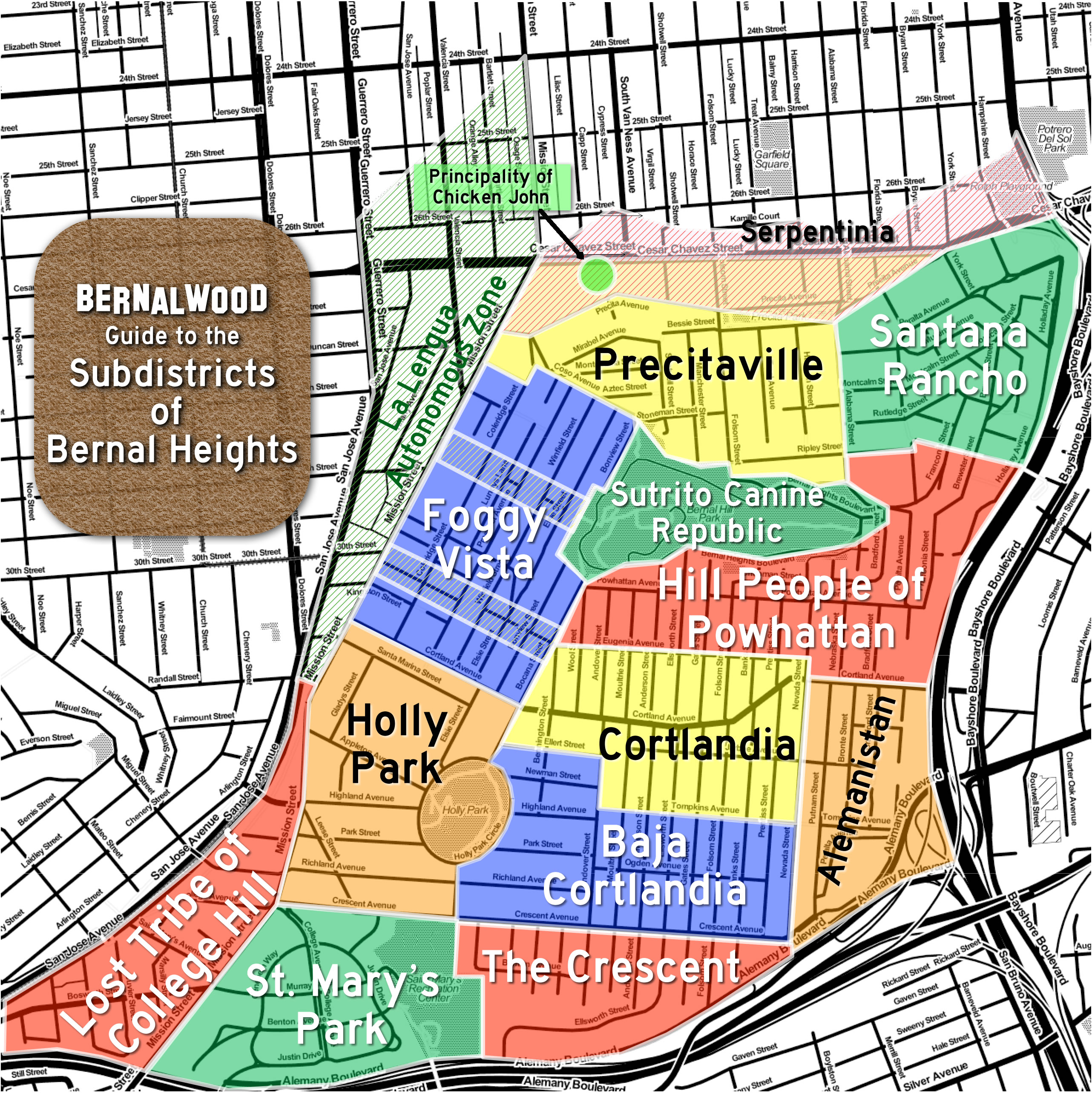
I looked at Bernal micro-neighborhood differences, based on Bernalwood’s subdistrict map:
Quite honestly, not a whole lot of difference. For South Bernal, most precincts went Clinton, with Sanders winning only south of Holly Park (in precinct 7944, which includes a bit of the Holly Park sub-neighborhood and a bit of the Baja Cortlandia sub-neighborhood).
The most interesting discrepancies can be found in North Bernal, where Sanders won the precincts bordering Mission and Cesar Chavez, with Clinton winning the precincts going up the hill and over to Cortland St. It looks to me there is something of an elevation issue for North Bernal — the higher up the hill you are, the more likely you were to vote for Clinton.
In the Wiener/Kim race, every precinct in both North Bernal and South Bernal favored Kim, except three: the two precincts that make up The Lost Tribe of College Hill (which Wiener now represents as their district Supervisor, and which he won handily) and a single precinct in The Hill People of Powhattan subregion, directly above the 101 (where Wiener squeaked out a win). Kim won every other Bernal district by fairly large margins, across the board.
The second interesting takeaway is that Kim’s totals did not mirror Sanders’ totals. For instance, Kim’s strongest precinct in Bernal was 7936, in Cortlandia, which was also a Clinton stronghold. It’s tempting to say that quite a few Kim voters broke right and voted for Clinton (or that quite a few Clinton voters broke left to vote for Kim), but it bears observing that more people voted for Kim/Wiener than voted for Sanders/Clinton. This is no doubt due to the nonpartisan nature of the Kim/Wiener race, meaning that that election was on every ballot, where the Clinton/Sanders race was only on the Democratic ballots (which some “no party preference” voters could request if they wanted).
It’s hard to know, then, how much gender may have played a role in Bernal’s vote totals (accounting for Kim and Clinton winning the neighborhoods) vs. how much did the third-party voters play a role in the Kim-Wiener race.
One final detail: The Department of Elections says that voter participation was 49.9% of registered voters in North Bernal, and 46.3% in South Bernal.
So there you have it, Citizens! Very special thanks to Neighbor Adam for crunching the numbers, and onward we go to the General Election in November.

Just wanted to say thanks for that, neighbor Adam. Super interesting! 👍🏼
Agreed! I love reading the hyperlocal results.
Great analysis, Adam!
Quibble: we don’t say “the 101” in northern California.
Hah — good quibble, and I stand corrected. The six months I spent in SoCal 12 years ago were apparently pretty corrupting. Either that I’m just surrounded by too many SoCal folks here in Frisco.
Ha. Well played Adam.
Long before the National Interstate and Defense Highways Act of 1956 gave most U.S. cities their first freeways, Los Angeles had built several. These weren’t simply extensions of federal interstate highways through the city; they were local routes, engineered to carry local traffic and (partly) paid for by local funds. It only made sense that, as they opened one by one, they’d get local names, ones that succinctly denoted their route or destination. The freeway through the Cahuenga Pass thus became the Cahuenga Pass Freeway, and Angelenos knew the freeway to San Bernardino as the San Bernardino Freeway.
State highway officials did affix route numbers to these freeways. But clarity dictated that Southern Californians continue to use their descriptive names. In their early years, most Los Angeles-area freeways bore signs for multiple numbered highway routes. The Pasadena Freeway, for example, was Route 6, 66, and 99, all at once. The Harbor Freeway carried both Route 6 and Route 11. The Hollywood, Route 66 and 101. Who wouldn’t prefer the simplicity of a name over a confusing array of numbers?
How, then, did that morph into “the 405 to the 110, the 110 up to the 101, the 101 to the 5, the 10, the 5, the 110, the 134”?
In 1964, the state simplified its highway numbering system, ensuring that, with few exceptions, each freeway would bear only one route number. Around the same time, a flurry of new construction added unfamiliar freeway names to the region’s road maps. Drivers found it easier to learn new numbers like the 605 or the 91 rather than new names like the San Gabriel River Freeway or the Redondo Beach Freeway.
Although the transition was gradual – numbers only eclipsed names in common usage in the late 1970s, and Caltrans still included the old names in signage through the 1990s – Southern Californians eventually joined the rest of North America in referring to freeways by number. But when they did, they retained their old habit of prefixing a definite article, the, giving rise to a regional idiom that still confounds and amuses outsiders today.
https://www.kcet.org/shows/lost-la/the-5-the-101-the-405-why-southern-californians-love-saying-the-before-freeway-numbers
The only trouble with this explanation is that Northern California also has named freeways, such as “The MacArthur”, “The Nimitz”, “The Eastshore”, and “The Bayshore”. And like Southern California, the names do not precisely match the Interstate or State highway numbers.
@David – Many of those Bay Area examples weren’t built until the 1960’s, after people were likely pretty used to the interstate numbering conventional. Furthermore, some of them were existing sections of State Routes that were only given “the” names after realignment. The Nimitz, for example, was partly the old SR-17, which was partly the old US-48. I can see why the “the” convention never made it into the vernacular up here.
Southern Californians, in contrast, had been driving The Arroyo Seco Parkway or The Cahuenga Pass Freeway (among others) for generations. Our one example is probably the Great Highway—though it was never replaced with a freeway and might be outside the scope of this conversation—is as old as any SoCal highway and proudly retains it’s prefix.
Thanks for your analysis.