
Once upon a time, in the Age of the Iron Dinosaurs, giant streetcars roamed around Precita Park in Bernal Heights. Precita Park was the terminus for the Market Street Railway’s 36 Folsom Line, which carried passengers to and from the Ferry Building via Folsom Street between 1915 and 1945. In the magnificent aerial photos of Bernal Heights captured in 1938, the streetcar lines around Precita Park were clearly visible:

The 36 Folsom entered Bernal from Folsom on the west end of Precita Park. It then followed Precita Ave along the southern edge of the park before making a quick jog onto Alabama. The line then turned back onto Precita Ave., continuing east down the street to the intersection with Army (today’s Cesar Chavez). There was no turnaround, so for the return trip to the Ferry Building, the streetcar just reversed itself.
Today’s history geeks owe a great debt to the streetcar geeks of yesteryear, because their obsession with streetcar photography and documentation today provides us with a trove of vivid images that makes it possible to see what this part of North Bernal looked like during the early decades of the 1900s.
Take this shot for example. This is Precita at Army as it looked during the 1920s, with the intersection with York Street visible to the left. This spot is very familiar to most contemporary Bernalese, so it’s fun to check out all the detail this image has to offer:

The most obvious thing to notice is that the divey little gas station that now sits on the triangular lot between Precita, Cesar Chavez, and Bryant used to be a rather divey little saloon:

Amazing! Wieland Beer was a San Francisco brew, manufactured at a brewery that used to be on 2nd Street between Howard and Folsom.
Notice also the battered barber pole just to the left of the Acme Beer sign, alongside that Joad-ready truck. Behind it is the building which would later become the world-famous Sheepskin City and Battery4Prius.
At some point, of course, this bar was replaced by a gas station. For comparison’s sake, here the exact same spot, as it looked circa 1970, at the moment when Steve McQueen begins the famous car-chase scene in Bullitt:

The left side of the streetcar image provides a clear view west up Precita Avenue, with the southeast corner of Precita Park visible in the background, and ample parking available for rickety-looking motorcars:

We’ll zoom into Precita Park in a moment. But first, here’s a reverse angle, showing the 36 Folsom at Army Street, looking to the southeast. That’s the south slope of Potrero Hill in the background:

Google Street View confirms that the houses on that side of Precita still look pretty much the same today.
Backing up Precita, we get some terrific views of Precita Park. Here’s Alabama at Precita looking northeast. The exact year is unknown, but it looks like the early 1940s, judging from the styling of the car in background:

The building on the corner in the right side of the image is now the fabulous Precita Park Cafe (as shown here), but back then it was… a SAFEWAY?!

Spinning 180 degrees from about the same spot, we get the reverse view looking toward the southern edge of the park in 1939:

That’s the future Precita Park playground site on the right, and some very lax parking enforcement on the left. Here’s a closeup of the streetcar itself:

Finally, there’s this amazing photo, which Bernalwood has previously explored. This is the view of the 36 Folsom tracks from the other end of the park, on the southwestern corner of Precita and Folsom, as it looked in 1943:
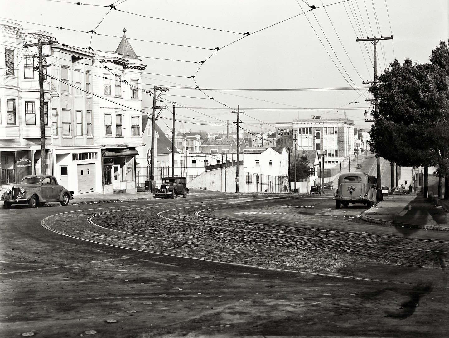
Here’s an annotated version:
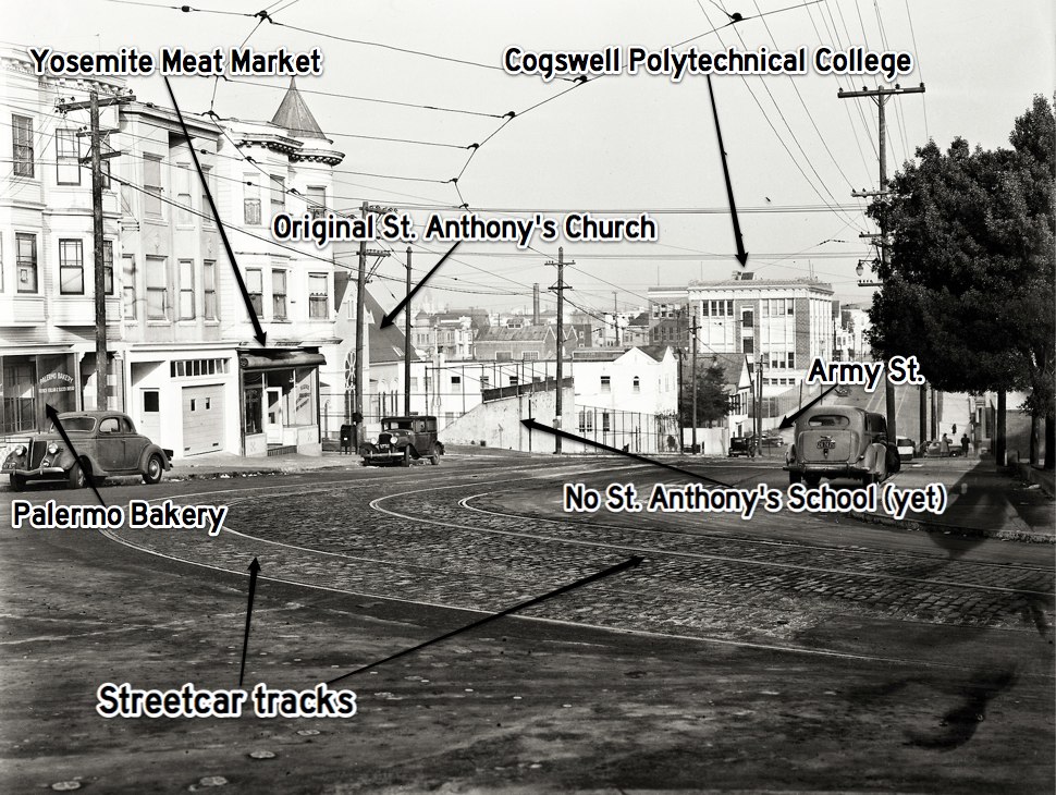
The Palermo Bakery is now home to Precita Clean laundromat, while the Yosemite Meat Market on the corner is the location of today’s Charlie’s Cafe.
Very special thanks to our friends at Open SF History, Rick Laubscher from Market Street Railway, and Bernal Neighbor Michael Nolan for sharing the photos that made this Magical History Tour of Precita Park possible.

Awesome article! I wish the streetcar was still here!
Many thanks. One of your best articles so far! Love the history and also the old cars, since that’s my hobby.
Very nice piece, Todd. Lots of information I didn’t know before. Can you insert my first name in front of my middle name? Thanks, Michael David Nolan
Excellent views of the old ‘hood! What’s up with Sheepskin City though? I mean, I can’t believe that they actually sell that many car seat covers to survive? Do they REALLY sell Prius batteries?? Alaways confounded me. To add to that, have you ever noticed a SFPD patrol car parked adjacent to the store on Cesar Chavez for hours on end?……….Just sayin’
Would love to see the 36 Folsom return. Among other uses, it would be wonderful for North Bernalese to get to the ballgame.
Todd, this post about trolleys around Precita Park is so well done. Thank you. Your blog is a fantastic resource for us Bernalese (Anderson St., since 1982). Special thanks for the coverage of the terrible Mission St. fire and notices about helping the victims. Bravo! Grazie Mille. Neighbor Alan.
Thank you. Fascinating
Re: Precita and Army photo — Is my perspective off or is there really a house smack dap on the top of Bernal Hill there?
pretty sure the house you’re talking about is 18 Bonview
Great article – thanks – I really appreciate your blog!
Thanks! I’m a streetcar geek and I hadn’t seen several of these photos. In “the day” photography was expensive, so what we see mostly is photos of weddings, school graduations, and other occasions. So, yes, the streetcar geeks are our link to the everyday non-occasion life in SF.
Some SF transit terminology: We have (1) streetcars, which are electric and run on tracks, (2) cable cars, which run on tracks but are pulled by a cable under the street, (3) trolley buses, which are electric and run on rubber tires, (4) LRVs, known as “light rail vehicles” not because they’re light, but because they’re lighter than a conventional train passenger car — an LRV is a streetcar that was built after 1975, otherwise it’s the same as a streetcar. In SF we don’t use the term “trolley” by itself. An older term for a trolley bus was “trackless trolley”, but that term hasn’t been used since the 1950s.
What I notice in the shot of Precita at Army in the 20’s, instead of the divey saloon, are the lone houses atop Bernal hill. Must have been a delightful, private view from the kitchen window.
But where are the bicycle lanes?
(Very nice article!)
Bicycles? Weren’t they a big trend back in the 1890s? Here in the modern 1940’s only kids ride bikes.
Growing up on Precita next to Le Conte School makes me appreciate these pictures evermore. Born there in 1949. Great pictures. Thank you.
Pingback: This Weekend: Ride a Vintage Muni Bus (Almost) to Bernal Heights — for Free | Bernalwood