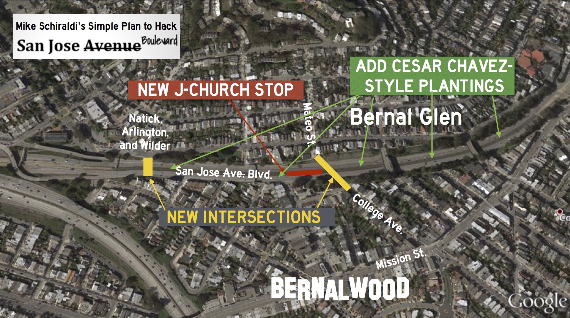
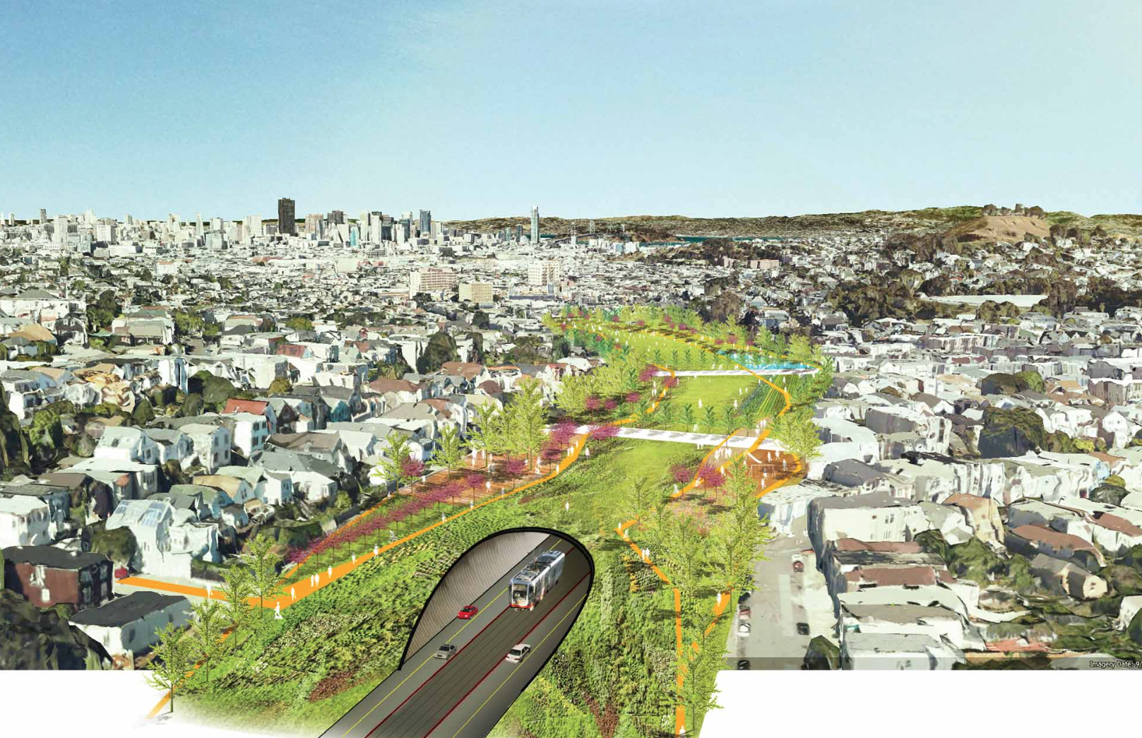
Remember that fabulously ambitious idea to rethink the speedway portion of San Jose Avenue through the Bernal Cut? The visionary set of ideas that focused on ways to reintegrate San Jose Boulevard into the Bernal-Glen streetscape?
That was some mind-expanding stuff, but it wasn’t just fantasy. Tomorrow, Tuesday, January 19 at 6:30 pm, there will be a community meeting with the SFMTA to discuss some down-to-earth proposals to re-unite Bernal Heights with our ancestral kin in Bernal-Glen. Mike Schiraldi from Bernal-Glen has been leading the charge to make this happen, and he explains why you should attend:
Tomorrow night is the MTA’s big community meeting for the SJA Road Diet. It’s very important to let them know how many San Franciscans share a vision of San Jose Avenue that’s less like a freeway and more like a boulevard.
The “I ♥ SJB” refers to the San Jose Boulevard slideshow that brought you all to this mailing list. “Fund the study!” refers to one of the declared goals of the Glen Park Community Plan, created and endorsed by the SF Planning Department and the Glen Park Association in February 2012. It called for a study to be conducted by February 2017 to investigate the feasibility of reconnecting San Jose Avenue to the local street grid, adding a new J-Church stop, and, effectively, de-freeway-izing it. The problem is, we haven’t heard peep about the study in years. Let’s get it back on track!
Please come if you can make it; a single in-person appearance at an event like this is volumes more effective than, say, 50 snarky comments on NextDoor and Facebook. Here are the details:
Tuesday January 19th, 6:30-8:30pm
Glen Park School Auditorium
151 Lippard AvenueThere’s decent parking availability after school hours, and the address is also very transit-accessible.

As a bicycle commuter, I’m normally in favor of such changes, but I think that it’s shortsighted to remove too many of the major transit arteries into/out-of the city. As we continue to restrict vehicular traffic flow at multiple points in the city, eventually we’ll be left with huge idling car lots spewing emissions into our neighborhoods. Already the bottleneck caused by reducing the northbound lanes is obvious. There are no fewer cars traveling the route, but a twice daily traffic jam developers (and accidents) during rush hour where the lanes merge. I agree that the stretch could use some improvement, but I think that turning into a park like setting is going to far. I’d rather see improvements to public transportation — like a Bart station at 30th street – to get people out of there cars rather than simply increasing drive-times into/out-of the city without creating viable transit alternatives.
YES. YES. YES.
Must we ruin every single traffic artery in the City? Every street can’t be made car un-friendly. It simply ignores reality.
Beautify, yes. Make public transit more inviting. More carrot. Less stick.
Was the Embarcadero ruined when they took out the freeway? Was Cesar Chavez ruined when they revamped it a few years ago?
You can have a major artery that’s not a freeway.
Replying to sj below. When they took a lane out of Cesar Chavez and took a lane out of the exit at SJ ave then yes, for cars they did ruin it.
The traffic on both is much worse now. In the short term, these changes probably pissed off a lot of drivers and the real anger management problem driver is more likely to cause an accident.
I’m sure if you ask old timers who live in north beach, nob hill, pacific heights, the marina if knocking down the embarcadero freeway ruined things, they would probably say yes. Especially if they need to get out of the city going south.
Do all of these places look better now after the changes? Sure, and I’m not a big driver so I welcome the beautification of the embarcadero, etc. But we are making this city harder and harder to navigate with a car. Fortunately, many companies are providing shared transit to work otherwise who knows what kind of carmageddon we would have.
“There are no fewer cars traveling the route” — actually, that’s not true. Come to the meeting and learn the details!
+1
This is frustrating, I just hit +1 to Robert’s post and it appears below ‘SJ’s, definitely NOT my intention.
Cesar Chavez doesn’t really back up that terribly bad. It backed up before, too, remember. For me the redesign greatly improved the street. I drive it all the time as well. All the time. Daily, at all hours. It simply is not that bad to deal with, and it looks and feels so much better.
Kenny, I respectfully disagree. I drive Chavez regularly, and in my opinion it is backed up more often. Additionally, I live on Precita and we’ve noticed a significant uptick in traffic on our road trying to avoid delays on Chavez. Another regular bypass route is Coso to Folsom and then Precita to avoid the traffic delays.
This question is a historical side note, but does anyone know what the route of the route of the old San Jose Road (original El Camino Real) was prior to the construction of the road through the Bernal Cut? Some old maps make it look like the route followed what’s now 30th, Chenery, and Diamond Streets through Glen Park, which would explain the location of Glen Park’s business district.
I’m fearful! Without meaningful public transport improvements, changing the atmosphere does not fix the traffic situation. We already have 3 obvious misjudgements:
1. Cesear Chavez is frequently blocked westbound. Drivers respond by driving to gain a few feet of advantage, make unsafe lane changes, cut off the timid. Nice landscaping!
2. Chenery & Diamond now, with one less lane in each direction, has traffic backed up, mostly from the west and south, most of the day. A glaring mistake: the two lanes going east to the outhbound 280 entrance becomes one lane when a bus pulls in to BART! There are alot of Google, etc. buses that stop there, increasing unsafe traffic flow.
3. One less lane now on San Jose, in addition to a new bike lane ( without many bikes) from the exit of 280 north. People drive creatively, to put it politely.
The reality is complicated but these changes are simplistic answers. Three are enough, please!
CC backs up, westbound? not really. The issue with CC is its backup, eastbound during evening commute hours. Westbound? just be patient and it will all unwind within a minute or three.
Where the freeway passes over ( and CC dips under it) cars feed in from Potrero (south) as well as emerging from east. It’s not the delay, it’s the cutting across lanes as they merge together. Lots of macho driving. It does sort itself out after a block or two. But it seems a spot ready for a bad accident.
There are times with San Jose backs up onto 101, creating a serious freeway traffic issue. I hope this is considered.
I commute (carpool) home on San Jose around 530 and almost always jump off at St Mary’s, driving down a residential street and making a left at a poorly controlled intersection onto Mission. Otherwise it can take 5+ changes of the light to get off that strip. I’ve seen that the exit onto Bosworth gets backed up as well. Reducing to 2 lanes has created a big bottleneck, with no real thought given to how else folks can get from 280 to this corner of the city.
I applaud the notion of “de-freeway-ization,” but only if alternate routes are available, or traffic calming doesn’t lead to traffic jams
I like the St. Mary’s exit off San Jose, too, but I usually turn left mid-block onto College (?), which winds through a narrow right hand turn to connect you to Mission across from Crescent.
There are some very thoughtful / reasonable comments here but it doesn’t look like the City considers such thoughts. While I get the push to make the streets of San Francisco safer, San Francisco is part of a larger community (the Bay Area) that is close to many places to visit or that are only accessible by car. It seems like the City is turning a blind eye to increased traffic caused by its planning decisions.
There are clear advantages to projects such as tearing down (parts of) the Central Freeway in Hayes Valley, but that just pushed traffic onto Fell/Oak/SOMA. And while more housing is needed (espeically infill), building without parking or increasing MUNI service just seems short-sided. Without alternatives of reliable and reasonable regional public transportation. cars will be here to stay for the foreseeable future. People still need to get to work and get around the Bay Area on a daily basis and I for one am not going to say you should only relax or vacation wherever there’s a bus line.
I consider myself a sane and respectful member of the community who supports this idea. I’m not coming to the meeting however because I don’t want to waste my evening listening to people yell at each other.
I’m a supporter of making aesthetic improvements to the corridor and sensible changes to improve access to and from the city as part of a master plan to ease traffic congestion area-wide. I am opposed to a narrow-sighted approach to improving one neighborhood’s traffic woes by shifted them to another area. Having said that, I too will pass on the meeting. I’ve seen these types of meetings deteriorate into a shouting match. No thank you.
IT’S TIME to unthink the freeways entirely. We need to shut down the Bayshore freeway and turn it into a bike route and walkway. Put the traffic back onto Potrero and Bayshore Blvd, which would give and added boost to neighborhood businesses in those areas. How many thousands of people totally bypass The Old Clam House and the Silver Crest diner who could be eating there?