Once upon a time, during the Age of the Ancient Druids, the peoples of southwestern Bernal Heights and northeastern Glen Park were united as one. During that time, our Bernal lands extended continuously to the west, and the Lost Tribe of College Hill was not yet lost. Bernal soil filled the void that divides us today.
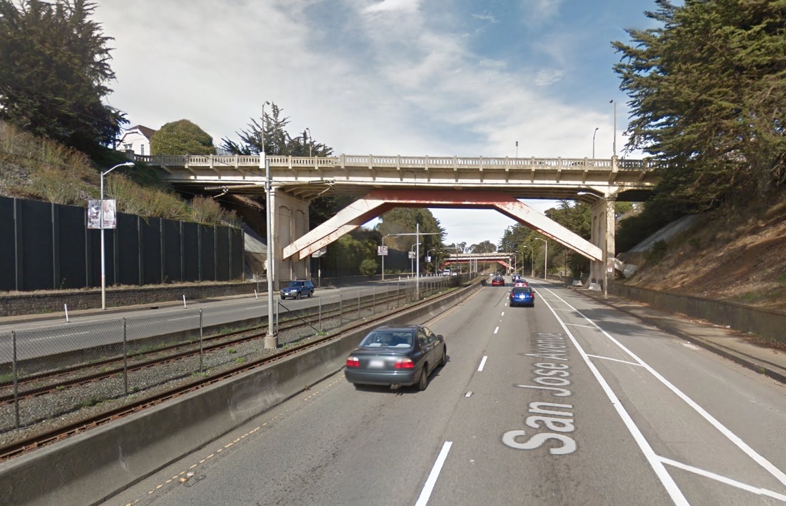
The void that divides Bernal from Glen Park today is called the Bernal Cut, and it now carries a streetcar line and auto traffic that speeds along San Jose Avenue to and from I-280. It is very unlovely:
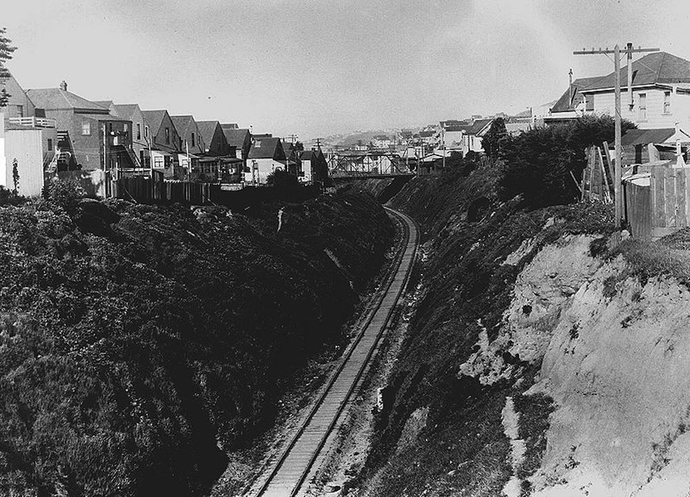
Originally, the Bernal Cut was a Southern Pacific railroad line carved out of a low shoulder of Bernal Hill’s west slope during a series of late ninteeenth century excavations. Here’s a view of the Bernal Cut during the railroad days, looking north toward modern-day La Lengua from the Richland-Miguel overpass in April 1922:
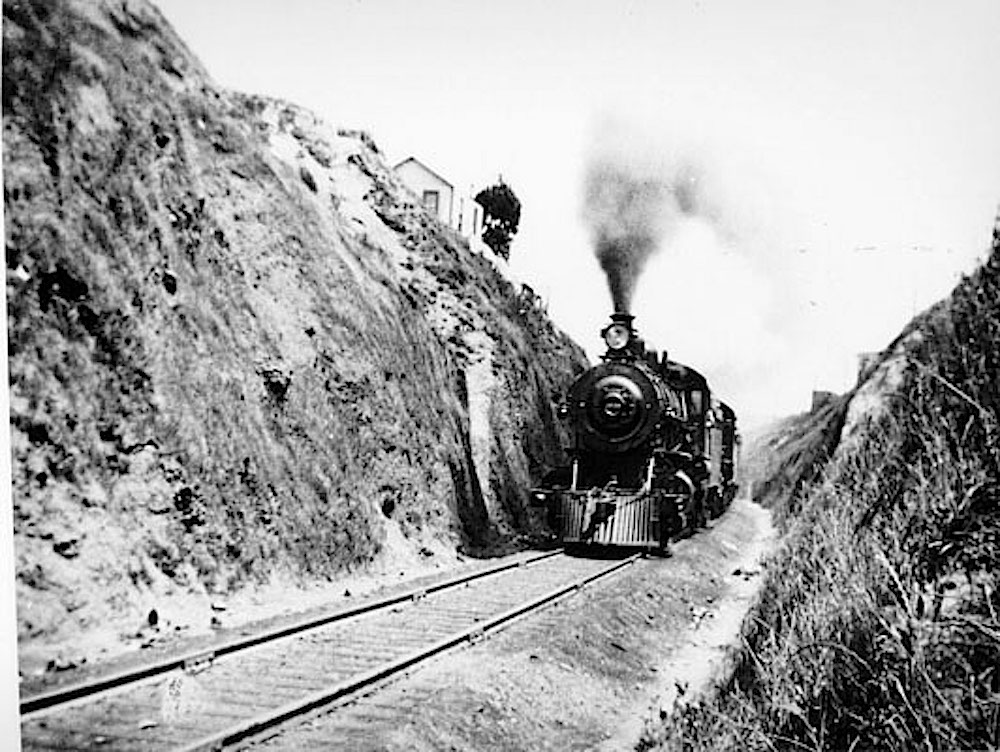
Throw in some smokey steam locomotives, and you can see why The Cut became particularly daunting to cross. This is a train chugging through the Bernal Cut in 1905:
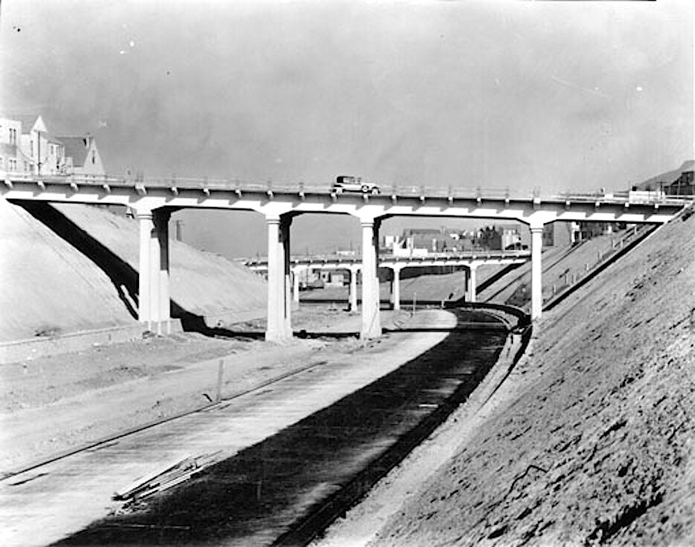
Then came the age of the automobile, and in the late 1920s, the cut was widened and expanded to create an arterial road into San Francisco’s urban core. Here’s another north-facing view, this time from 1929, when the construction of the roadway was almost complete:
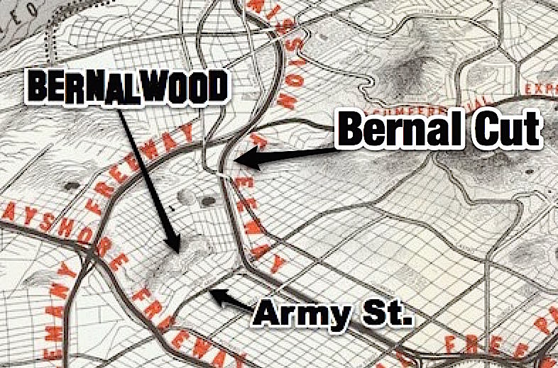
The vision at the time was that the Bernal Cut would become the first stage of a new Mission Freeway that would carry high-speed traffic into downtown San Francisco. Here’s a crop from a 1948 planning map that shows how all that would have worked, in rather horrifying detail:
Basically, in much the same way that Army/Cesar Chavez used to suck because it was designed to feed a freeway that never actually got built, so too the Bernal Cut now sucks because it too designed to serve a future that never really materialized. The Bernal Cut has been dominated by vehicular traffic for more than 100 years. That may have been a necessary and worthwhile thing, yet it also divided the neighborhoods on either side, and for the neighbors who live there, it’s a big bummer.
Fortunately, there are a few armchair urban planners and civil engineers who live on the Glen Park side of the Bernal Cut — an area which they (quite revealingly, and charmingly) call “Bernal Glen.” In recent years, our kin in Bernal Glen have hatched a few brilliant plans to re-unite the mainland people of Bernal Heights with our descedents from Bernal Glen. One such plan is described here by Bernal Glen neighbor Erika Ehmsen:
In 2013, a College Hill/Bernal Glen neighbors asked renowned landscape and urban design firm SWA Group to visit San Jose Ave. SWA designers and planners walked with neighbors along San Jose Ave., the Bernal Cut Path, the Arlington Path, and our bridges and pedestrian overpass to experience the grim current state of San Jose Ave.—from its freeway-like speeds to its trash-strewn and encampment-prone slopes and sidewalks.
SWA designers asked us to suspend our current reality in order to reimagine and reinvigorate our blighted speedway. We showed SWA the Glen Park Community Plan and asked them to envision an extension of that plan that could incorporate the slopes above San Jose Ave. while reflecting our College Hill Neighborhood Association’s greening and safety goals. And then SWA got to work sketching the plans in that above Google Doc presentation—all pro bono.
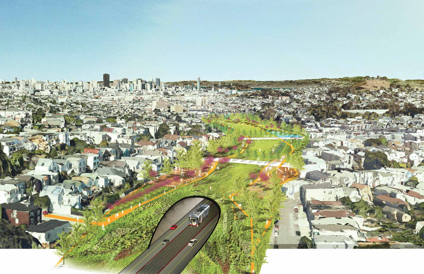
Here is that SWA presentation; it is rather trippy and mind-expanding. One proposed scenario would involve re-filling the Bernal Cut with soil after creating a tunnel for the tracks and roadway underneath. It’s just a simple “cut and cover” tunnel design, basically — but the cut part comes pre-excavated 150 years ago.
This idea would seamlessly re-unite Bernal with Bernal Glen by eliminating the trench between them, while also creating 13 acres of new land that could be used for a mixture of new housing and parks. And though the proposal itself doesn’t suggest this, in theory at least, the sale of land to build that much-needed new housing could actually go a long way toward paying for the whole thing.
Here’s what it might look like, as visualized by SWA:
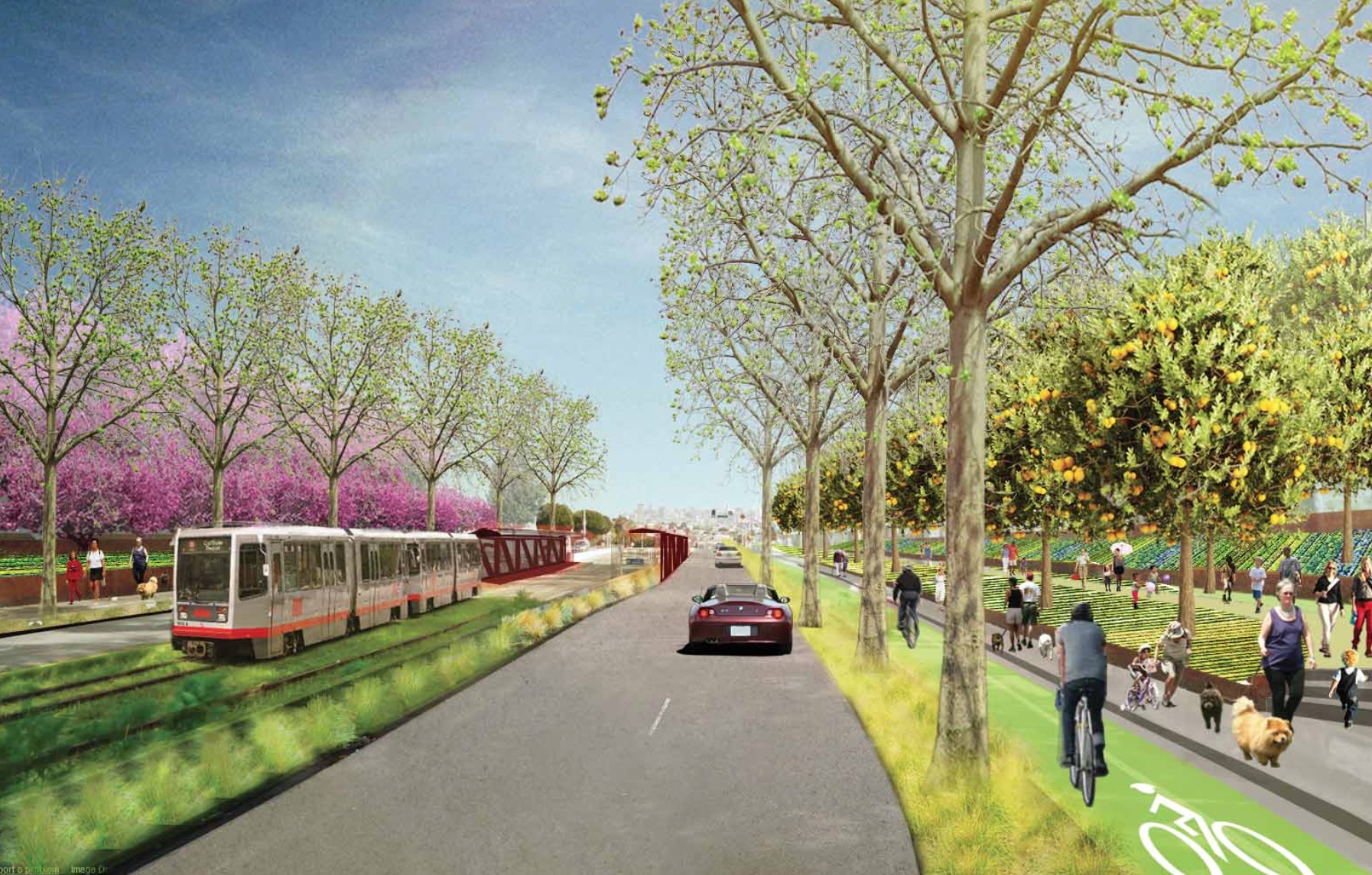
If a tunnel seems too sci-fi, another scenario envisioned in the exercise would narrow the roadbeds and terrace the walls to create land for urban agriculture. This is what tomorrow’s “Bernal Cut Farms” might look like:
Innnnnnnnnteresting, no? We might quibble about some of the details, but the big breakthrough here is that it gets you thinking about the Bernal Cut in all sorts of crazy new ways. There’s a lot of land in there! And it’s really under-utilized! So many possibilities, even while retaining The Cut’s core transportation functionality. Yes! Yes! Yes!
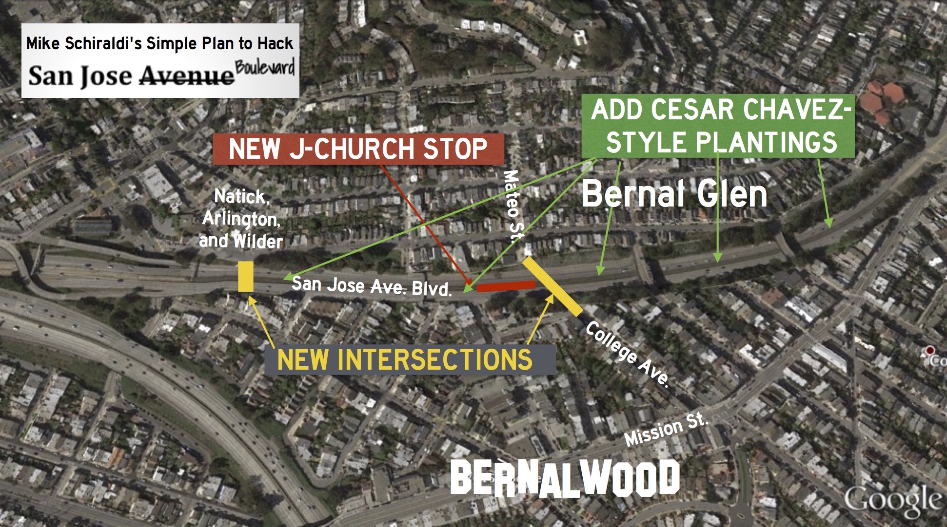
Meanwhile, and more recently, Bernal Glen neighbor Mike Schiraldi decided to pick up on this basic idea and pare it back to the bare essentials to develop his own plan for how to heal the Bernal Cut. Mike says:
Well, the Glen Park Community Plan spends a couple paragraphs dreamily talking about undoing San Jose Avenue, but doesn’t get into any details or explain the benefits. So while I’m not the first to talk about ripping it out (duh), I tried to get down to brass tacks, to see how it could actually get done. And I wanted to illustrate how transformative it would be, since it can be hard to see that from the Glen Park Community Plan.
Inspired by the improvements that recently transformed the once-awful Cesar Chavez/Army into today’s much more glamorous boulevard, Mike’s let’s-do-this idea is to do the same basic thing to the speedway portion of San Jose. To slow traffic and make it easier to move between the two microhoods, he proposes re-connecting a few of the surrounding streets via new intersections with San Jose.
Specifically, his plan would create a new traffic light/intersection at Natick, Arlington, and Wilder Streets in Glen Park and one linking College Ave. in Bernal with Mateo Street in Glen Bernal. He calls this scenario “San Jose Boulevard”:
Both of the two new connections could be full intersections, with traffic lights, allowing traffic to flow in any direction between San Jose, Natick, Arlington, and Wilder, or between San Jose, College, and Mateo. There could be crosswalks too, so pedestrians and cyclists can get across without having to use an overpass, which is awkward, often dirty, and can be scary at night.
Oh, and to further activate the areas and create even more pedestrian activity, Mike also proposes adding a new J-Church stop along his new San Jose Boulevard, since the streetcar already runs there anyway:
Large sections of Glen Park which are currently underserved by transit would suddenly become extremely transit-accessible, both because of the new J-Church stop, and the new crossing opportunites.
You can read all about it in Mike’s brainstorming presentation, where he makes the case in a lot more detail. It’s clever. It’s not complicated. It may even re-activate the Bernal Cut as a shared space that joins the Dominion of Bernalwood with our kin from Bernal Glen. Let’s do (something kind of like) this!

I LOVE this. So beautiful and community-building. 🙂
Idiotic plans. Have you seen the traffic jams the recent reduction of 1 lane (for 1 or 2 bikers an hour!) has caused. Like it or not San Jose Ave is a major artery feeding into the system. The 3rd lane into the city should be reopened again.
that third lane was allowing people to go 20-30 mph over the speed limit. I’d rather lose 1 min or two than have someone have to ride next to 60 mph+ traffic. Have empathy for others. Drivers are not the only people who use that corridor.
Plenty of bikers along San Jose Avenue, north and south. San Jose Avenue should not just be viewed as an artery that cuts a neighborhood in half so drivers can get to Lower Noe Valley and the Mission easily.
Third lane did nothing to ease traffic. It is the light at Randall that is congested and causes back up – Muni resets the light. And is it so important to go over 35 mph anywhere in the city? No . There will eventually be a light at mission and Randall which would have eliminated the third lane anyway. We are just preparing for that to happen . You won’t even be able to turn right off SJ ave and onto Randal NB. Patience in your car. There is a school right on the corner and people need to slow down in prep for Guerrero corridor anyway.
Great to hear you spent multiple hours counting bikes on San Jose Ave. Thanks for doing that. Can you give us your full methodology and data?
What’s that? You just made that number up? Oh.
Come at me, Bro.
Peter seems to have diarrhea very often and that extra 2 minutes has really messed him up on numerous occasions. I think you guys should really give him a break.
Peter is right. One minute added to the commute? Try 20! The traffic has gotten horrendous since they closed the third lane. I’m fine slowing down to 35, but why should I have to wait through 10 light cycles to get into the city? SF has become more and more unfriendly to cars, and with transit in the area as crappy as it is, some people have no choice but to drive. I’m not going to do a 2-hour MUNI to BART to Caltrain to get to work every day.
You’re a victim of bike-trification.
Why would anyone bike on noisy and dangerous San Jose when there is bike friendly Arlington right next door?
Many of the bicycle routes I encounter regularly are placed on major arterial roads when there are much less trafficked side streets one or two blocks over. It has puzzled me since their construction.
The two times I have asked why, using the exact same words as my first sentence, I received replies that, ummmm… let’s just say they weren’t especially warm and fuzzy, or enlightening.
No sympathy for those who choose to drive; it’s their choice to sit in traffic. Traffic will NEVER magically go away in this increasingly overpopulated world, so there’s no point in crying about it.
“No sympathy” is often the problem in our world.
Here’s an empathy exercise: When was the last time you drove a car? Why did you drive a car at that time? Now extrapolate that instance to every other person on the road, rather than assume that people just “choose” to drive for some nefarious reason.
It always seems weird when people get all get righteous about biking and have NO SYMPATHY for motor vehicles yet are perfectly happy to buy food, drinks, art installations all kinds of things brought there buy neanderthals like me in delivery trucks. Also wait till you get old or injured and can’t bike up SF hills. Sympathy, tolerance, compromise, consideration for others . . . these are virtues. Intolerance, objectification of others, these are the hallmarks of extremists.
Yep.
Religious belief tends to trigger the same rhetoric and mind-set.
If a group of people can band together to stop things from getting built surely a group can unite to create something positive. I am 100% in favor of this. I would be curious what the cost would be and how feasible it would be to create it through privately funded donations, something similar to the bay lights project. Or a blend of public and private funds.
The only trouble is that the Bernal Cut Farms rendering shows levels of pedestrian density that are higher than even Mission Street typically gets, and orders of magnitude higher than on any street that has nothing fronting on it. To get anywhere close to that level of activity, the street will have to be lined with businesses, which is not likely with so little width available to be reclaimed from traffic lanes.
I kind of like the idea of the cut-and-cover cap, which could actually create some usable land in the blocks where the cut is deep enough to be covered.
I had the exact same thought, Eric: The levels of pedestrian activity shown would only materialize if you built housing+retail in the cut. There’s actually a fair amount of room for that if you were to build in the areas currently used for the sloped walls of the cut.
The cut-and-cover is ridiculously elegant, but sadly not-cheap.
There are so many pedestrians and bikers along the cut,, both above and below. I see them. I use it. I know people who use it to ride bikes to SOMA area from Miraloma area. It’s important for pedestrians, bikes and cars. It’s just not known to many that there are alternative travel routes .
The scale of the Boulevard rendering is also suspect. The MUNI car is too small even considering perspective. And agree that the pedestrian traffic is a bit optimistic. But the beautification idea is still worthy.
The cut and cover is a good idea because it addresses all sides: drivers and MUNI will be able to retain current travel speeds (if not go faster) through the tunnel, while cyclists can use paths added to the new above ground parkland. Win-win. Likewise pedestrians and joggers will have use of that park.
I walk Lower Cortlandia to GP Village round trip practically every day. Not a day passes that I don’t wish the Cut paths were less sketchy — I’d love to get off the busy streets during my walk, but it just feels like a great place to get mugged. I adore the idea of a new J-Church stop; it has the benefit of being relatively low cost while bringing better transit to the neighborhood and more foot traffic to the area, which will increase safety. The SWA tunnel is gorgeous but I think have a better chance of seeing a 30th Street BART stop (read: almost none) before we ever got anyone downtown to take the tunnel plan seriously.
The Cut and Cover option is a remarkable idea. Yes, I’m sure it’s VERY expensive, but like the proposal to shorten the 280 freeway, it creates new property for development and public space. At that time you could optimize the transport arrangements in the tunnel to reduce congestion, which was worsened in the last bike lane/traffic calming redesign.
I would vote for the cut-and-cover. Mike’s proposal has some good aspects, but it would seem to encourage a lot more traffic on residential streets.
I absolutely love the tunnel- oh joy- could it be done before we are all buried like the traffic ?? the presidio tunnels demonstrate how attractive this solutions is. and the subway to nowhere downtown project proves that if there is political will you can do anything regardless of $$
i started calling it bernal glen when the 94110 side of the cut along mission was gladly given to Weiner as part of his oversight and I can tell u that since then we have had so much more improvement in the neighborhood. I overlook SJ avenue. While noisy at all time except 3-5 am, it is a good location!
This makes me sigh. This city could be world class but in the infighting will never let it happen.
This can’t happen soon enough
I never minded the old format of Cesar Chavez and don’t mind the current set-up of San Jose Ave, but…
If the neighborhood really wants to get something as bold as the tunnel funded, I’d propose more and denser housing and less green space than pictured in the SWA rendering. Considering the housing zeitgeist and the current make-up of the BoS and City Hall, this may be the best way to get the issue addressed in the shortest timeline.
San Jose Blvd seems like the most likely outcome, but I think the linked presentation overplays the difficulty of navigating 280/SJ-to-Glen Park for drivers, as well as the drawbacks of pedestrain/bike use of the existing SJ overpasses which connect GP to College Hill/St. Mary’s Park. Ideally, there’d be a raison d’etre greater than just traffic-calming; right now I don’t see enough commercial activity/space on that stretch of Mission that demands more connection of the bisected area. How do the residents of Chenery, Arlington, Bosworth, and College feel about re-zoning their streets from residential to neighborhood commercial or neighborhood commercial transit?
Bernal Cut Farms seems like a pipedream. All it does it slow traffic to raise property values for the neighbors.
Love this. And totally relate. SJ reminds me of all the weird viaducts and postindustrial railroad dreck I remember seeing out the windows of the car when I was a kid riding in the back seat on the way to go visit my grandparents in Jersey City.
I feel the same way about the big crane at the Hunters Point Shipyard; the one that you can see from Bernal and 101.
the tunnel is a brilliant idea, especially if the new land creates housing and commercial along Randall to bring GP, Bernal and Mission St together in a more meaningful way.
Were the bridges painted an attractive shade, it would do wonders for what I’ve always considered to be a Parisian part of SF.
The proposal is pie in the sky nonsense.
It isn’t a proposal, and anyway there were two ideas presented.
Sorry, but this comes across as a late-90’s vision of a grass-roots neighborhood. What your illustration lacks is right-lane cut-outs for the Google Bus stops to service the high-rise condos that will line the new boulevard.
IMHO The tunnel idea is lovely, but I don’t like the idea of turning San Jose into a regular city street. Adding more intersections would even slow muni down, which I didn’t think was physically possible.
This isn’t an opinion on what “should” be done; it’s just an alternate take to consider or not.
I’ve traveled through the cut for 19 years now, several times a week on my 1.5 mile commute home from work. There are often faster routes; but there’s something strangely comforting about that stretch of the City I hope I can put into words.
Yes it’s easy to dismiss as ugly, industrial, imperfect, ungreen, gravelly, hard, etc… Yet it’s one of three places in the City that remind me of the South and Midwest where I grew up, in a good way. I don’t know if others ever had the childhood experience of walking along train tracks with scattered, rusty buildings behind concrete levees as a backdrop. What are the best words to convey the feeling? Dusty melancholy that isn’t sad? Lonesome happiness? The solace of imperfect juxtapositions? Are kids even allowed to wander nowadays? Are they allowed to explore things that are dirty and rusty just for the sake of kicking around and thinking?
There are certain times of day in certain parts of the year where the quality of the light here in San Francisco can take your breath away. An already beautiful landscape becomes almost unreal. The angle of the sunlight; the chaotic colors of the houses reflecting into the air; the prismatic effect of salty air… I’ve tried to describe to friends in other parts of the world that quality of light. It’s impossible to imagine if you haven’t seen it (or ever stopped to notice it), or if unusual atmospherics aren’t your thing.
The Cut is kinda like that to me: pleasing in a way that’s hard to describe, and hard to understand if you’ve never experienced similar functional architecture in native settings.
It may sound sappy or bizarre; and it is just one person’s opinion (a person who was glad that there were still a few gravel roads in Bernal when I first moved here). But that little stretch of San Jose makes me feel wistful BECAUSE it isn’t perfectly manicured and picturesque. Because it looks out of place. We have industrial-ish streets left in SF. But not many concrete-canyon-train-track-and-gravel-chain-link cuts through tree-lined surroundings. In any other setting it would be unremarkable. But dropped here in San Francisco where it is lit by our version of the sun, it’s a surprising break from the perfection, like a scar you hate that your spouse inexplicably loves.
The drawings all look lovely. They are–objectively–more user-friendly versions of the area. I understand the desire to scale up, enhance, unify… but I’ll miss it when it’s gone: something boldly unpretty, something slightly jarring and just… different.
Get yourself out to Hunters Point before they level everything and build the condos. I love the view from there, and the remnants of the shipyard, the rusting hulks, warehouses and rotting piers. It’ll be a nice neighborhood someday, but it’ll never have the same kind of beauty it’s had over the past 25 years as the Navy slowly withdrew.
I have spent a lot of time there. My kitchen is an homage to Building 253.
I completely agree with you, Snobby. I’ve spent many hours there, and even had the chance to spend some time in off-limits buildings, some full of massive old equipment that hadn’t been stolen or auctioned, but rather left to rust in peace.
This is completely insane, and I agree fully with it.
The tunnel plan is more of that over-manicured crap you see in the mid west. SF *USED* to be a blue collar industrial city where people earned a living. You can see remnants of that all over, this cut is one of them. A gritty reminder of what it once was and will be again once the latest wave of invaders go bust and go home.
Another spot like this is on Rincon HIll, where old SF met the new mass of the Bay Bridge in the 30’s. That remained for many years, but now has been removed for the new, which is fine, it grew out of necessity. The bridge displaced some of the old development where it needed to, leaving the rest to soldier on. Now the bridge remains and is now the old, while new things rise up. I bet if you scrounged hard enough, you will still see parts of pre-bridge SF poking through.
Burying the Bernal Cut is fake, creating a fake world for people that don’t understand why it is there in the first place and recreating something that hasn’t existed for over 100+ years. Hell when they first dug it out it was ranches and farms.
I just read Byrd’s comment. Roughly the same sentiment; much more concise.
“Parisian” is interesting to think about…
🙂
the tunnel idea looks amazing but I would hate for it to turn into the Stockton or Broadway tunnels – there’d be no bike improvements at all. This connection is the only flat route south without going all the way around Bernal Hill. Though maybe since this is pie in the sky anyway we could get one of those bike elevators to get up to the top of it 🙂
Oh please can we have climbing walls on the walls of the Cut? I mean, I do love the cover the cut and create 11 acres of land for housing, etc. but I really love the idea of an outdoor climbing gym right here.
Don’t settle for either/or. DEMAND BOTH!
yes to tunnel + outdoor climbing!
I will support your climbing walls if you support my funiculars.
This is some great thinking.
Also – it’s time to recognize that San Jose is southern SF’s equivalent of “the Wiggle” – our bike route connection to the rest of the city.
Yes! I, for one, am angry that even a single need of bicyclists remains unrecognized. The terrible neglect bike riders have suffered through of late must end!
Agreed. I like where they’re going with this, but the tunnel option doesn’t appear to include any bike infrastructure.
That’s because by the time this is built, bicycles will be obsolete.
The cyclists would use the parkland over the tunnel.
Pingback: Today’s Headlines | Streetsblog San Francisco
“There will eventually be a light at mission and Randall which would have eliminated the third lane anyway. We are just preparing for that to happen . You won’t even be able to turn right off SJ ave and onto Randal NB.”
Really??? This would make for all kinds of traffic weirdness to get from there to Bernal. As it is I do the turn onto St. Mary’s and the sketchy left onto Mission to avoid the long slog along San Jose up to the traffic light. With no rt turn onto Randall from SJ, I guess all traffic would have to go up to 30th and then a right and a left to get to Cortlandia? Or through the Taoist Safeway parking lot?
The “Cut and Cover” tunnel would be the best idea. I would like for it to be designs like the Devils Slide tunnel near Pacifica, which would allow for quick two lane traffic through car and Muni, but to include bike lanes, with fans that keep air circulated. Once you fill in the cut and allow for a long park like the Panhandle to GG Park, the Beranl and Glen Park communities could really use that area. Living here for the past 15 years, I’ve always hated how traffic comes barrel in down SJ ave. And I’ve seen and heard many bad car accidents on 30th and SJ. Commuters need to slow down, find a different route, or just give yourself 20 extra minutes if you plan to come into SF from the 280. These neighborhoods are not freeways, there are children crossing the street at Randell, families getting ice cream at Mitchell’s, people getting groceries at Safeway, and a needed freeway exit for people in Glen Park. This are will continue to gain in popularity because of the cross section of hwy, streets, muni and Bart. Extra pedestrian park space is needed for the continued growth happening in Bernal Glen, and Noe Valley. To ignore the rate of growth and think everything will return to normal when and if another bubble pops is short sighted. Growth and neighborhood improvements will continue regardless, mainly because our fair city is so great. “Bernalwood” has just surfaced, “GlenTech” will be next, and the next innovation that brings prosperity to our fair city will increase to population once again. SF is here to stay, and we need to find new and innovative ways of dealing with our growth. Like it or not, this is our city, live with it.
The City could easily and somewhat inexpensively connect the neighborhoods using the existing overpasses and pedestrian walkways which run parallel to San Jose Avenue. It seems that with some thoughtful planning they should be able to connect the Bernal/Glen Park/Noe by improving Mission Street sidewalks and also improvements to the walkways. Also, San Jose Avenue is very wide so that an elevated bike path could be put in if one side walk was removed. I do think its odd that they always want to put bike lanes on busy streets which Arlington is much calmer. It seems that a transit first policy does not need to also create congestion. We don’t need the emissions from idling cars filling up our lungs. We need to move cars, trucks, buses and shuttles efficiently and safely through the city. Cesar Chavez now has huge back ups and cars, buses, and trucks are sending out emissions to all the people who live in the houses and housing projects which line Cesar Chavez. The City has made a commitment to corporate shuttles which move between the South Bay and SF. Why do we want them to sit in traffic? Currently, traffic on San Jose Avenue comes to a stand still during rush hour – obviously, well below the 35 mph target. Yet, a driver can speed down San Jose Avenue at 3am. Traffic speed is hard to control because it is dictated by car volume. I would like to see a transit first, congestion free plan which links the neighborhoods together for San Jose Avenue. I like the tunnel idea but all of this is extremely expensive. The open space is great, but the city does not have the money to maintain the parks and open space we currently own. Unless, citizens are willing to raise funds for infrastructure, the most practical approach would be to work with existing pedestrian pathways and overpasses to create connection.
For what it’s worth, I’m fairly certain the bike path isn’t on Arlington is because of the significant incline you would have to climb at the intersection of San Jose, Randall and Arlington (if you were coming from Dolores).
Pingback: Highland Street Bridge Now Closed Until Further Notice | Bernalwood
Pingback: Your Hyperlocal Analysis of 2015 Election Results from Bernal Heights | Bernalwood
Pingback: Tuesday: Important Meeting to Advocate for the Defreewaytization of San Jose Avenue | Bernalwood
Pingback: Big Winter Storm Knocks Down Trees Around Bernal Heights | Bernalwood