Along time ago, in the office of a city planner far, far away, a plan was hatched to solve San Francisco’s traffic problem.
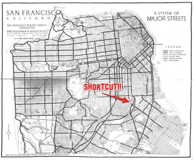
The year was 1928, and the San Francisco Traffic Survey Committee had mapped out a vision for the future that involved widening selected city streets to adapt them for use as major arterial throughfares.
Bryant Street in the Mission was to become one such proposed artery; it would carry much of the traffic traveling between South of Market and the Peninsula via Bayshore and San Bruno Avenues. But how would all those vehicles get from Bryant to Bayshore (and vice-versa)?
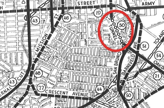
Why, through the Bernal Tunnel, of course!!
Look closely, and it’s right there: A short tunnel running under present-day Franconia Street to whisk motorists through layer upon layer of our beloved Bernal Hill chert. One end of the tunnel would open roughly at the intersection of Holladay and Faith, and the other would disgorge traffic at the site of what is now that weird triangle-shaped gas station at the junction of Precita, Bryant, and Cesar Chavez.
Notice the other plans in store too. Like, for example, completing the street grid across the top of Bernal Hill via a much straightened-out Esmerelda Avenue (presumably after much of the hilltop was quarried and flattened). GENIUS! No Bernal Hill Park! No unseemly wildlife! No feral radish! Just a few dozen more homes, and a much more tidy drive around the neighborhood… all in the name of Progress.
PHOTOS: Unedited version of 1928 map via the ever-fabulous Eric Fisher


I don’t think that Esmerelda was actually part of the plan — that was just the Department of Public Works base map that they were drawing on top of. It was one of the “paper streets” that were part of the original subdivision but were never built. DPW maps in the 1940s started distinguishing between streets that actually existed and those that were just on paper, but by then Bernal Heights Boulevard had been built too.
Oh, and if you like tunnels under Bernal Heights, you’ll love the 1944 plans for the Mission Parkway.
Here seems like as good a place as any to try out this new urban planning idea: bike escalators! Listen, this is going to be great. It will be like the grocery cart escalator in Bed Bath and Beyond, only outdoors. I’m thinking it can shoot right up Alabama. You can also affix your baby stroller to it. So convenient and efficient! So Jetsons! Ski lifts could work, too.
Molly! YES! I like the way you’re thinking. Those bike elevators do exist, I think. I remember seeing something on the YouTube. But really, a ski lift would probably be more versatile for all-season fun.
Oh my god, you’re right!. I can live without the patent. When can we get one of these things?
Also interesting things of note in the plans:
1. The proposed Broadway Tunnel in the plans was actually completed in 1952.
2. The Bay Bridge was proposed to head straight east in SOMA instead of north-east as it eventually went.
3. The Branch County Jail at Balboa Park is now CCSF. Draw your own conclusions. Just kidding.
4. There is a place south of Silver Avenue called “Lick Old Ladies Home”. Hmm.
Does anyone have information on the remnants of a tunnel at Bayshore and what would be Costa or Faith if it went under the freeway?
Kinda to the left as you end your decent from the pedestrian freeway overpass. It’s bricked and cemented up, and begging for an unbricking and exploration. ( Or not.)
Please see link below for various reasons to open or further cement this possible vector:
http://www.crystalinks.com/hollowearth.html
En D. Joy
There is some background on the name of the Morris Olson Tunnel from Olson’s daughter in the comments to Whole Wheat Toast’s picture of the portal. I can dig up the California Highways and Public Works article from when it was built if you want.
Yes please. Also, so… where IS the other end of that tunnel??
I tried to follow the link for background on the name of the Morris Olson Tunnel. Do you still have some information?
OK, I’ll scan it. I don’t think the other end of the tunnel is accessible any more — I think it is underneath the current bridge. I took a couple of pictures of the gate that I think probably led to the tunnel and what I think may have been a handrail on the incline.
I was going to reference the Morris Olson tunnel, but Eric beat me to it! 🙂 Very interesting stuff.
Pingback: This Proposed Freeway Tunnel Under Bernal Heights Would Have Destroyed My Home | Bernalwood