 Let’s do some time travel, courtesy of the Bernal History Project (from whence this fantastic image came our way).
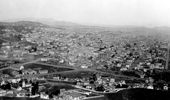
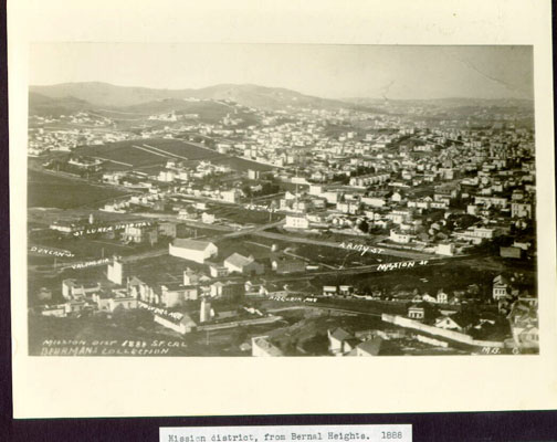
The year is 1888, and the place is the intersection of Mission Street and Army (now Cesar Chavez Blvd.), as seen from Bernal Hill.
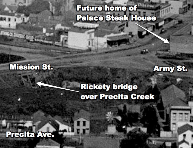
The resolution of this photo is extremely good, so let’s zoom in to take a closer look. We’ll start right at the intersection of Mission and Army. No Palace Steak House yet, and Precita Creek is still an exposed, swampy mess:
A little farther south on Mission, we see some points of interest in the future La Lengua Autonomous Zone. There’s an awesome shed on Valencia painted with ads for Hood’s Sasparilla and The San Francisco Morning Call newspaper. We also see the site of the future El Rio, as well as the building that would later become Mission Chevrolet before becoming today’s O’Reilly Auto Parts. The Bancroft Library stands on the future expansion site of St. Luke’s Hospital. And what’s up with that lighthouse-like tower on Coso (which is also visible here)?

A little to the northwest, we see the intersection of Valencia and Army. Here too, Precita Creek is a muddy ravine, but that big brick building that’s now the Salvation Army on Valencia and 26th is clearly present. At the time, it was a shoe factory.

Lastly, we head east along Army, to the intersection of Army and Howard (later renamed South Van Ness). Apparently, Howard didn’t yet continue through to Army. Also, note that big, bendy building on Army, purpose unknown. UPDATE: Mapmeister Eric Fischer identifies the big, bendy building as the home of the North Star Brewery! Image Annotation added below.

Thanks for journeying back through time with us. Feel free to geek-out with the high-res version of the full 1888 image on your own; please report back if you find anything interesting.
PHOTO: Courtesy of the Bernal History Project

Great post! Burrito Justice had a thing on the Salvation Army building, but I cannot for the life of me remember what it was. I want to say a Piano Factory, but that could be completely wrong.
He says it was a shoe factory. I’m conspiring with him to resolve the questions above. More to follow.
Shoes? Pianos? Same thing.
…maybe that’s why my feet always hurt.
@ Todd and B Justice. It was indeed a shoe factory. The shoe factory was located adjacent to the tanneries on Serpentine Street. Serpentine Street ran parrall with a branch of Islais Creek. In my research on the development of NW Bernal, I came across soil reports findings that indicated that there were traces of arsnic in the soil. Arsnic was used in the tanning of cowhides. Before the land speculators, NW Bernal was scattered with dairies which was adjacent to a water supply.
I suspect with the on slaught of the land speculation, one being a high profiled SF politician, there was a push to clean up Serpentine Street for health reasons… thus.. the Army Corp of Engineers comes to the rescue.
love this stuff! fun fact: 26th St. used to be… Navy St. It also used to stop/start right at Guerrero (I believe) and then later was extended to the bay (and correspondingly re-numbered).
Beat me to it. I wonder if there is a garage somewhere with an old sign that says “It will always be Navy St!!!”
heh now that would be a serious old-timer!
Very cool. I was wondering if the large building with and the advertisements, behind O’Reilly Auto Parts could be the garage that is accessible from Valencia Street. Although currently connected, those two spaces feel like separate buildings.
Clifton, that garage was the back end of Mission Chevrolet, a Chevy dealer that erected the building that is now O’Reilly Auto Parts during the 1920s. Showroom was the current store; the repair shop was the Valencia Street garage. Have you ever noticed the awesome bas-relief designs of old cars in the frieze of the garage on the Valencia side?
Interesting! I had always assumed it was the automotive repair portion of the old Sears-Roebuck Store behind it on Mission St!
The former Sears auto repair shop is today’s AAMCO transmission shop next door to the Valencia garage to the north.
Our family owns the building next door (since 1939). Currently is Wash Station and Mission Neighborhood Health Center. There was a hay barn on the south side that my father purchased along with the vacant lot to the south and “put in a parking lot”. When I was a child in the 1940s, Mission Chevrolet was Stewart Chevrolet (before moving to Colma)
Clifton, you will want to look at my post on that block. That area was rife with horse-related industry, and it transformed into an area rife with auto-related industry.
Seconded. That post is great!
Third….fantastic post!
I love this stuff. Thanks to the Bernal History Project and Bernalwood for sharing it!
Your lighthouse-like tower is probably a water tankhouse. I notice in the earlier picture a windmill and water tank house. I grew up out in the country & those were everywhere.
That makes sense! This was apparently the site of a small quarry at the time. Burrito Justice is researching to confirm.
It’s definitely a water tank, but I’m wondering what sort of business it was associated with. Blacksmiths/Farriers and stables often had associated water sources.
Agreed. Unfortunately the 1886 Sanborns for that block are badly washed out.
BTW here’s the show factory from the 1899/1905 Sanborns.
Aaaand here’s the link.
http://maptcha.org/image.php?id=588
Thanks, BHP. This is great!
I’m surprised nobody beat me to it, but the bendy building seems to be the North Star Brewery (Sanborn 1899 sheet 578).
North Star FTW!
http://maptcha.org/image.php?id=534
yeah you can see right where it was on Army north of the bendy part of Precita. And look at long-lost Serpentine Ave! (“width not defined”) 🙂
OK, here’s a surprise — our bendy building is not the North Star Brewery! At least not in 1886. It was the “C. Hellwig Glove Leather Dressing” tannery. Looks like North Star didn’t get started until 1897, but the funky glove factory (hey, free band name! (and so is “Hellwig” but I digress)) impacted the layout of the brewery.
For those wishing to play at the advanced level of tonight’s game, why was the tannery bendy?
Will post more tomorrow.
Speaking of anomalous buildings in that general area, any idea what’s up with the apartment building on Cesar Chavez just east of Mission St that sits sort of offset/at an angle to Cesar Chavez? All the other buildings around there sit flush up against Cesar Chavez, but this one doesn’t.
You mean the one nextdoor to the Principality of Chicken John, yes? Good question.
Yeah, that’s the one.
I had always assumed the front of the diagonal building followed an old property line, but the 1938 aerial photo on David Rumsey’s site shows the entire lot built over, with what appears to be two different rectangular buildings, one at the front and one at the back. My guess, then, is that the current building was a redevelopment of the back of the lot, with the diagonal front so that light could reach the windows, and the front building was demolished later—maybe when the street was widened?
This is a really weird one. That funky diagonal building doesn’t show up until the 1950 Sanborns, but the 1915 Sanborns show a print shop set back from Army the same distance as Chicken John’s place. Also, that front building visible in 1938 doesn’t show up in 1915 or 1950…
I like your sunlight theory, but if they did tear down the back building, how would people have gotten to it from Army? It looks like la casa de pollo (to the east) was built in 1910, and the lot to the west had a house set pretty far back in 1915, and another set much closer to Army in 1950 (which you can also see in the 1938s).
I have officially confused myself at this point — hopefully I will be able to explain this in BurritoVision tomorrow.
The main Bancroft Library Building was at 731 Market near 3rd. Destroyed in the earthquake of ’06 and rebuilt. Many of the volumes saved because they were stored in the Outer Mission on Valencia south of Army. There’s a nice photo exhibit in the lobby of the Bancroft Building today at 731 Market.
I thought Bancroft moved his library entirely out of 731 Market to 1538 Valencia around 1880 when he ran out of room (he grew from 120 boxes to 622 boxes in 10 years), and then moved to Berkeley in 1906 after the quake.
http://burritojustice.com/2010/09/16/history-of-a-tree-a-branch-a-block/
(Also, 1538 Valencia != Outer Mission. Outer Mission touches Daly City.)
I’m loving this general geek-out! Thanks, Burrito Justice, for defending the OM. I’m a big fan of Cayuga Park, and always feel that neighborhood gets shorted when people call other places Outer Mission… Thanks, MDN, for the tip about the photo! Lunch break idea! 🙂
re: the mystery tower… assuming TL has correctly IDd the locations for El Rio and Kragen/O’Reilly, that means the street entering (later on?) right there at Mission would be Precita. Which means that the street to the left (in the photo, actually going SW) would be Powers (formerly Powell). And that would mean the tower would be near the corner of what is Powers and Coleridge today… no?
hmm which in ~1888-ese, would be the corner of Powell Ave and California Ave. It was probably a good thing they ditched the majority of the Street and Avenue duplicate names. 🙂
ok so the Sanborn maps from 1886-1893, Vol 5, 1886, in particular sheet 141(a) seem to have some info on the area where we have El Rio/Kragen today. take a look: http://i.imgur.com/7u4ow.png
See http://burritojustice.com/2009/10/21/el-rio-31-el-rio-123/
ok more pedantry here… but I think I found the Sanborn map from 1886 that has the tower. No ID on the property per se, but the structures seem to jibe between what’s on the map and the structures visible in the 1888 image. at first I didn’t think so, but now that I give the foreshortening some more consideration..it seems like a good hit. this is from Vol 5,1886,140_a : http://imgur.com/a/3GX75
Is that large sunflower-like structure underneath the caption “Rickety Bridge over Precita Creek” in the second photo above a windmill?
It is!
Thanks! Very cool post and comments. For anyone like me obsessed w/the california tankhouse, here’s a vid with extant examples in The Sunset: http://www.outsidelands.org/historyminute/1292868202/SunsetTankHousesandWells; you can also see several East Bay examples along the BART Fremont line. Two geeky little questions: in the second close-up diagram, wd the little building marked “Future El Rio” probably actually be the building next door (3156, not 3158) and the street marked “Coso,” probably really be Coleridge (the white Victorian on the corner seems to be still standing)?
I think you’re right, where it says “coso” looks to me like Coleridge and Powers. I think that building may still be there too, but no longer has a bay window on the first floor.
Good eye — the “Future El Rio” is in fact to the right/north of the actual future El Rio — see the 1886 Saborn map at http://burritojustice.com/2009/10/21/el-rio-31-el-rio-123/
And you are two for two this evening — that house with the tall vertical window is indeed on Coleridge not Coso.
I will try to get up a post tomorrow explaining this with big animal pictures.
While we’re on the subject; anyone come across any old pics of Coleridge street? I’m just about a block down from the aforementioned and would love to see previous iterations of my place (1914 and onward, that is.)
What a pleasant diversion on a rainy day. Did some genealogical research on the McTigue family, the harness makers. Michael McTigue and Frances Acton were Irish immigrants born in 1830 and 1832 who started the business South of Market . In 1872, they were living at 273 Minna, In 1880 on 8 1/2 Moss. with children Augusta, Fanny, Joseph, Richard, John and Jennie. By 1896 they were living at 19 Alvarado with their harness factory at 3156 Mission Street. Joseph W. McTigue was born in 1866 and died in 1939. He married Mary Theresa Costello and they had a daughter, Marie. She married William Dabel and in the 1940 census they lived at 3182A Mission Street. They had a son William (1927-2006) and I”m trying to trace his descendants.
Wow! That’s awesome.1866-1939, the things Joe must have seen.
He saw the end of horse transportation. In the 1920 Census, his occupation is listed as Leather Worker in a Livery. In 1930, Joe is a government clerk.
Without doing more research, the diagonal building on Cesar Chavez you’re talking about (3365 Cesar Chavez) appears to have been moved onto the lot from across the street, presumably when Army Street was widened. If you take a look at the 1938 aerial, you’ll see an angled building on Capp across the street with two light wells in a nearly identical position, just reversed. Thus, when the building was moved, it was swung around 180 degrees so that the old south portion of the building (facing Army Street) became the new north portion. As large as that building is, they certainly moved larger.
By jove, I think you are right! Check it out:
Great graphic!
Btw, one of the other cool things I noticed in the overall photo is that you can see the train station at Valencia and 25th Street. It’s two blocks north of the Salvation Army building, sitting by itself at an angle on a largely undeveloped parcel.
OMGWTFBBQ
Worst. Tetris move. Ever.
Now I wonder if the building that was on the Palace Steak House’s parking lot was moved anywhere…
I should also add that, architecturally, the building looks like a product of the 1920s, and the Planning Department gives it a date of 1927. Why they placed it so deeply on the lot after moving it I can’t say, but a very logical guess is that they intended to build something else fronting on Cesar Chavez.
It’s not on the 1915 Sanborns, though the neighboring building (now the parking lot for the former Palace Steak House) is, and is also visible in this 1931 SFPL photo.
Maybe the move was in the 40s as part of the plan for an even wider Cesar Chavez?
Link to 1931 SFPL photo:
http://sflib1.sfpl.org:82/record=b1009646~S0
According to a historic SFPL photo, Army Street was widened west to Harrison Street in the late 1930s. A caption accompanying the photo says “”The motorist moves nicely along widened Army-st until he reaches Harrison. Then Army narrows into an alley-like street, says Mr. Fixit, who hopes the city soon may have the money to finish the widening.”
My guess is that the owner of the apartment building saw the writing on the wall, and purchasing the lot across the street was a clever way to save his building.
http://sflib1.sfpl.org:82/search/a?searchtype=X&searcharg=%22army%22+street+widening&SORT=D
Do you have any data on how much it cost to move a building in those days? I have such a hard time wrapping my head around the concept.
that’s crazy..I can’t believe they moved an apartment building. but apparently this was not too rare. Here’s a piece on the moving of the Hotel Montgomery in San Jose: http://science.howstuffworks.com/engineering/structural/heaviest-building-moved.htm#page=2
er wait, that was in 2000. oops. 🙂 But I can’t believe they moved an entire apartment building back in the day! maybe they just re-used the plans and built it anew? that doesn’t make much sense, I guess. amazing.
Pingback: Bernalwood Reader Solves the Mystery of 3365 Chavez | Bernalwood
And some more on Army Street tetris.
hmm speaking of moving entire buildings, check out this Hartlaub piece on the Broadway tunnel and a great shot of an apartment building on the move, 1950. http://blog.sfgate.com/thebigevent/2012/12/13/dig-it-great-tunnels-of-the-bay-area/#8754-5
Pingback: Bernal Bräu: How the Thomas Brothers Make a Damn Good Beer in Bernal Heights | Bernalwood
Pingback: A Brief History of How Cesar Chavez/Army Street Became So Awful in the First Place | Bernalwood
Pingback: In Which We Explore an Aerial View of Bernal Hill, Circa 1924 | Bernalwood
Pingback: A History of the Former McTigue Harness Shop on Mission Street, as Shared by His Great-Great Grandson | Bernalwood